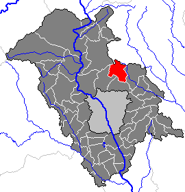
Земриах (Semriach, Semriach)

 Hiking in Земриах
Semriach, located in Austria’s Styria region, is a fantastic destination for hiking enthusiasts. The area is known for its picturesque landscapes, nestled in the foothills of the Eastern Alps, lush forests, rolling hills, and scenic trails. Here are some highlights and tips for hiking in Semriach:
Trail Options
- Gschirn Trail: This moderately challenging hike takes you through beautiful forests and offers stunning views of the surrounding Alps. Look out for local wildlife and flora along the way.
- Gschwendt Trail: A family-friendly trail that is suitable for all levels. It allows hikers to enjoy beautiful meadows and a peaceful atmosphere.
- Schöckl Mountain: Located near Semriach, this mountain offers various trails of differing difficulty levels. The panoramic views from the summit are definitely worth the hike.
Best Times to Hike
- Spring and Fall: These seasons are ideal for hiking as the weather is generally mild, and the scenery is at its most vibrant.
- Summer: It can get warm, so starting early in the morning is recommended. Make sure to carry plenty of water.
Tips for Hiking in Semriach
- Gear Up: Wear sturdy hiking boots and bring layers, as mountain weather can change rapidly.
- Stay Hydrated: Always carry enough water, especially on longer hikes.
- Respect Nature: Stick to marked trails to protect the local ecosystem and wildlife.
- Map and Navigation: Consider downloading a map or using a GPS device, as some trails may not be well-marked.
Local Amenities
Semriach has several local amenities, including guesthouses and restaurants where hikers can enjoy traditional Styrian cuisine. After a day of hiking, it’s a great way to relax and replenish your energy.
Safety Concerns
- Keep an eye on weather forecast before heading out.
- Ensure you have a fully charged mobile phone in case of emergencies.
- If you’re venturing out alone, it's advisable to inform someone of your plans.
Overall, Semriach offers a wonderful blend of natural beauty and hiking challenges suitable for all skill levels. Enjoy your hike!
- Страна:

- Почтовый код: 8102
- Телефонный код: 03127
- Код автомобильного номера: GU
- Координаты: 47° 13' 3" N, 15° 24' 12" E


- GPS треки (wikiloc): [Ссылка]
- Высота над уровнем моря: 709 м m
- Площадь: 60.35 кв.км
- Население: 3323
- Веб сайт: http://www.semriach.at/
- Википедия русская: wiki(ru)
- Википедия английская: wiki(en)
- Википедия национальная: wiki(de)
- Хранилище Wikidata: Wikidata: Q687706
- Катеория в википедии: [Ссылка]
- код Freebase: [/m/03gw2x9]
- код GeoNames: Альт: [7872346]
- код VIAF: Альт: [248604700]
- код австрийского муниципалитета: [60645]
Граничит с регионами:

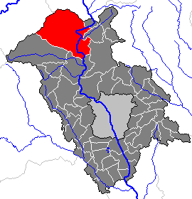
Sankt Radegund bei Graz
Hiking in Sankt Radegund bei Graz
Sankt Radegund bei Graz is a picturesque municipality located just a short drive from Graz, Austria. It offers a wealth of outdoor activities, including excellent hiking opportunities. The area is known for its beautiful landscapes, dense forests, and stunning views of the surrounding region, making it a great choice for both casual walkers and more experienced hikers....
- Страна:
- Почтовый код: 8061
- Телефонный код: 03132
- Код автомобильного номера: GU
- Координаты: 47° 10' 52" N, 15° 29' 22" E
- GPS треки (wikiloc): [Ссылка]
- Высота над уровнем моря: 717 м m
- Площадь: 21.60 кв.км
- Население: 2165
- Веб сайт: [Ссылка]
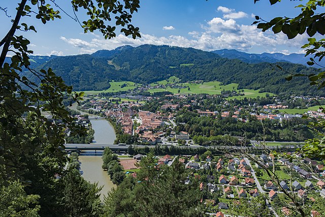
Фронлайтен
Hiking in Фронлайтен
Frohnleiten is a charming town located in Styria, Austria, surrounded by beautiful landscapes that make it a great location for hiking and outdoor activities. Here are some highlights and tips for hiking in this region:...
- Страна:
- Код автомобильного номера: GU
- Координаты: 47° 16' 13" N, 15° 19' 28" E
- GPS треки (wikiloc): [Ссылка]
- Высота над уровнем моря: 438 м m
- Площадь: 127.62 кв.км
- Население: 6655
- Веб сайт: [Ссылка]