Сигуайе (Sigoyer, Sigoyer)
 Hiking in Сигуайе
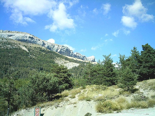
Sigoyer is a charming village located in the Hautes-Alpes region of southeastern France. It offers a picturesque setting and is an excellent base for outdoor enthusiasts looking to explore the scenic beauty of the surrounding area. Here are some highlights for hiking in and around Sigoyer:
Terrain and Landscape
- Scenic Views: The region is characterized by stunning alpine landscapes, rolling hills, and panoramic views of the surrounding mountains.
- Diversity of Trails: There are various trails suitable for different skill levels, from easy walks for families to challenging hikes for more experienced trekkers.
Popular Hiking Routes
- Sentiers de Grande Randonnée (GR Trails): The area is part of the larger network of long-distance hiking trails that cross the region, such as the GR 94, which explores various landscapes.
- Local Trails: Look for local marked trails that lead to historical sites, beautiful viewpoints, and natural features like rivers and lakes.
Wildlife and Flora
- The Hautes-Alpes region is rich in biodiversity. Keep an eye out for local wildlife, including various bird species and possibly even chamois or ibex in the higher elevations.
- The flora changes with altitude, featuring everything from lowland flowers to alpine plants.
Practical Considerations
- Weather: Be prepared for changing weather conditions, especially if you're hiking at higher elevations. It's advisable to check the weather forecast before setting out.
- Gear: Wear good hiking shoes and bring enough water, snacks, and a map of the area or a GPS device, as trails may not always be well-marked.
- Safety: Always tell someone your hiking plans, especially if you’re going solo.
Local Amenities
- Sigoyer offers basic amenities, including accommodations and restaurants, where you can enjoy local cuisine after a day of hiking.
- Consider visiting during the summer months when hiking is most accessible, and the scenery is in full bloom.
Whether you’re a beginner or an experienced hiker, Sigoyer and its surroundings provide a fantastic opportunity to immerse yourself in nature and enjoy the great outdoors. Always remember to follow Leave No Trace principles to preserve the beauty of the area for future visitors. Happy hiking!
- Страна:

- Почтовый код: 05130
- Координаты: 44° 28' 40" N, 5° 58' 33" E


- GPS треки (wikiloc): [Ссылка]
- Площадь: 24.38 кв.км
- Население: 664
- Веб сайт: http://www.mairie.sigoyer.com
- Википедия русская: wiki(ru)
- Википедия английская: wiki(en)
- Википедия национальная: wiki(fr)
- Хранилище Wikidata: Wikidata: Q1340747
- Катеория в википедии: [Ссылка]
- код Freebase: [/m/03m80qp]
- код Freebase: [/m/03m80qp]
- код GeoNames: Альт: [6618129]
- код GeoNames: Альт: [6618129]
- номер SIREN: [210501680]
- номер SIREN: [210501680]
- код тезауруса PACTOLS: [pcrtauNfxojJeT]
- код тезауруса PACTOLS: [pcrtauNfxojJeT]
- код муниципалитета INSEE: 05168
- код муниципалитета INSEE: 05168
Граничит с регионами:
Шатонёф-д’Оз
- коммуна во Франции
Hiking in Шатонёф-д’Оз
Châteauneuf-d'Oze is a charming village located in the Hautes-Alpes region of southeastern France. Nestled in the picturesque Oisans area, it's surrounded by stunning mountain scenery, making it an attractive destination for hikers. Here are some highlights and tips for hiking in and around Châteauneuf-d'Oze:...
- Страна:
- Почтовый код: 05400
- Координаты: 44° 30' 42" N, 5° 51' 53" E
- GPS треки (wikiloc): [Ссылка]
- Площадь: 26.23 кв.км
- Население: 27

Эспаррон
Hiking in Эспаррон
Esparron, located in the Hautes-Alpes region of southeastern France, offers a fantastic setting for hiking enthusiasts. Nestled in a picturesque part of the French Alps, Esparron provides a variety of trails suitable for different skill levels, making it ideal for both novice hikers and experienced mountaineers....
- Страна:
- Почтовый код: 05110
- Координаты: 44° 27' 13" N, 5° 54' 11" E
- GPS треки (wikiloc): [Ссылка]
- Площадь: 24.11 кв.км
- Население: 40

Фуйуз
- коммуна во Франции
Hiking in Фуйуз
Fouillouse is a charming village located in the French Alps known for its stunning natural scenery and excellent hiking opportunities. Situated at a high altitude, it serves as a great base for exploring the surrounding mountains and trails. Here are some highlights of hiking in Fouillouse:...
- Страна:
- Почтовый код: 05130
- Координаты: 44° 27' 27" N, 6° 0' 13" E
- GPS треки (wikiloc): [Ссылка]
- Площадь: 7.24 кв.км
- Население: 236
Неф
- коммуна во Франции
Hiking in Неф
Neffes is not a widely recognized hiking destination, so it’s possible that you’re referring to a specific area or trail that's less known. If you’re referring to a particular region, here are a few general tips and considerations for hiking in lesser-known areas:...
- Страна:
- Почтовый код: 05000
- Координаты: 44° 30' 16" N, 6° 1' 20" E
- GPS треки (wikiloc): [Ссылка]
- Площадь: 8.36 кв.км
- Население: 744

Пеллотье
- коммуна во Франции
Hiking in Пеллотье
Pelleautier is a beautiful commune located in the Hautes-Alpes region of southeastern France. Nestled near the foot of the Écrins mountains and close to the city of Gap, it offers a range of hiking opportunities that cater to various skill levels....
- Страна:
- Почтовый код: 05000
- Координаты: 44° 31' 1" N, 6° 1' 0" E
- GPS треки (wikiloc): [Ссылка]
- Площадь: 12.81 кв.км
- Население: 684

Таллар
- коммуна во Франции
Hiking in Таллар
Tallard is a charming commune in the Hautes-Alpes department of southeastern France, known for its beautiful landscapes and outdoor activities. While the area is not as widely recognized as some of the more famous hiking destinations in the French Alps, it offers a unique experience for hikers looking to explore less crowded trails....
- Страна:
- Почтовый код: 05130
- Координаты: 44° 27' 42" N, 6° 3' 16" E
- GPS треки (wikiloc): [Ссылка]
- Площадь: 15.02 кв.км
- Население: 2151
- Веб сайт: [Ссылка]


Витроль
Hiking in Витроль
Vitrolles, located in the Hautes-Alpes region of France, offers a fantastic environment for hiking enthusiasts. Surrounded by stunning landscapes, including mountains, valleys, and rivers, the area provides a range of trails suitable for various skill levels....
- Страна:
- Почтовый код: 05110
- Координаты: 44° 24' 44" N, 5° 57' 15" E
- GPS треки (wikiloc): [Ссылка]
- Высота над уровнем моря: 1000.0 м m
- Площадь: 14.62 кв.км
- Население: 206

Лардье-э-Валанса
- коммуна во Франции
Hiking in Лардье-э-Валанса
Lardier-et-Valença is a charming commune located in the Hautes-Alpes department in southeastern France. The region's natural beauty and varied terrain make it an excellent destination for hiking enthusiasts....
- Страна:
- Почтовый код: 05110
- Координаты: 44° 26' 5" N, 5° 58' 51" E
- GPS треки (wikiloc): [Ссылка]
- Высота над уровнем моря: 1015.0 м m
- Площадь: 14.86 кв.км
- Население: 329