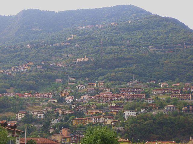
Сонгаваццо (Songavazzo, Songavazzo)
.svg)
- коммуна Италии
 Hiking in Сонгаваццо
Songavazzo is a picturesque village located in the province of Bergamo in the Lombardy region of northern Italy. It's nestled in the valleys of the Orobie Alps and is known for its beautiful natural landscapes, traditional architecture, and rich history. Hiking in and around Songavazzo offers a variety of trails suitable for different skill levels, allowing you to enjoy the stunning scenery of the Italian mountains.
Hiking Trails
-
Val di Scalve: This nearby valley offers multiple trails ranging from easy walks suitable for families to more challenging hikes for experienced trekkers. The routes here often pass through enchanting forests, alpine meadows, and provide breathtaking views over the valleys.
-
The Sentiero dei Fiori: This "Path of Flowers" is well-known for its diverse flora during the spring and summer months. It features panoramic vistas and is relatively easy, making it accessible for hikers of all abilities.
-
Cima Vignola: For those seeking a challenge, the hike to Cima Vignola is rewarding. This trail leads you to one of the peaks in the area, offering inspiring views of the surrounding mountains.
-
Parco Regionale delle Orobie Lombarde: This regional park is nearby and provides numerous trails that cater to various hiking preferences. It's known for its rugged terrain, rich biodiversity, and the opportunity to spot wildlife.
What to Prepare
- Footwear: Good-quality hiking boots are crucial. Make sure they are comfortable and have good tread for uneven terrain.
- Weather Gear: The weather can change quickly in the mountains, so dress in layers and bring rain gear.
- Hydration and Snacks: Carry enough water and lightweight snacks to maintain your energy levels during hikes.
- Maps and Guides: It’s advisable to have a map of the trails or download a hiking app for navigation.
Safety Tips
- Trail Etiquette: Stay on marked paths to protect the environment and avoid getting lost.
- Acclimatization: If you’re not used to hiking at higher altitudes, take it slow and acclimatize to prevent altitude sickness.
- Tell Someone Your Plans: Always inform someone about your hiking plans, especially if you're venturing out alone.
Local Attractions
Besides hiking, Songavazzo offers other attractions such as local cuisine, historic churches, and cultural sites. Consider taking a break to enjoy traditional Italian dishes in village restaurants, and possibly explore the nearby towns and their quaint shops.
Overall, hiking in Songavazzo can be a rewarding experience that combines physical activity with stunning natural beauty and cultural exploration. Enjoy your adventure!
- Страна:

- Почтовый код: 24020
- Телефонный код: 0346
- Код автомобильного номера: BG
- Координаты: 45° 53' 0" N, 9° 59' 0" E


- GPS треки (wikiloc): [Ссылка]
- Высота над уровнем моря: 640 м m
- Площадь: 12.94 кв.км
- Население: 706
- Веб сайт: http://www.comune.songavazzo.bg.it
- Википедия русская: wiki(ru)
- Википедия английская: wiki(en)
- Википедия национальная: wiki(it)
- Хранилище Wikidata: Wikidata: Q101590
- Галерея изображений в википедии: [Ссылка]
- Катеория в википедии: [Ссылка]
- код Freebase: [/m/0gjdyr]
- код GeoNames: Альт: [6543167]
- ID отношения в OpenStreetMap: [46358]
- UN/LOCODE: [ITSNW]
- код ISTAT: 016201
- кадастровый код Италии: I830
Граничит с регионами:


Кастьоне-делла-Презолана
- коммуна Италии
Hiking in Кастьоне-делла-Презолана
Castione della Presolana, located in the province of Bergamo in northern Italy, is a beautiful destination for hiking enthusiasts. Nestled in the picturesque Italian Alps, it offers stunning landscapes, diverse flora and fauna, and a range of trails suited for various skill levels. Here’s what you need to know about hiking in this charming area:...
- Страна:
- Почтовый код: 24020
- Телефонный код: 0346
- Код автомобильного номера: BG
- Координаты: 45° 54' 0" N, 10° 2' 0" E
- GPS треки (wikiloc): [Ссылка]
- Высота над уровнем моря: 986 м m
- Площадь: 42.5 кв.км
- Население: 3419
- Веб сайт: [Ссылка]


Черете
- коммуна Италии
Hiking in Черете
Cerete, located in the province of Brescia in northern Italy, offers a scenic backdrop for hiking enthusiasts. This area is characterized by its beautiful landscapes, charming villages, and Mediterranean climate, making it an attractive destination for outdoor activities, including hiking....
- Страна:
- Почтовый код: 24020
- Телефонный код: 0346
- Код автомобильного номера: BG
- Координаты: 45° 52' 0" N, 10° 3' 0" E
- GPS треки (wikiloc): [Ссылка]
- Высота над уровнем моря: 612 м m
- Площадь: 14.07 кв.км
- Население: 1597
- Веб сайт: [Ссылка]

Коста-Вольпино
- коммуна Италии
Hiking in Коста-Вольпино
Costa Volpino, located in the province of Bergamo in the Lombardy region of Italy, is a beautiful destination for hiking enthusiasts. Nestled near the shores of Lake Iseo and surrounded by the stunning landscapes of the Valcamonica valley and the Alps, it offers a variety of trails suitable for different skill levels....
- Страна:
- Почтовый код: 24062
- Телефонный код: 035
- Код автомобильного номера: BG
- Координаты: 45° 49' 50" N, 10° 5' 57" E
- GPS треки (wikiloc): [Ссылка]
- Высота над уровнем моря: 192 м m
- Площадь: 18.67 кв.км
- Население: 9151
- Веб сайт: [Ссылка]


Фино-дель-Монте
- коммуна Италии
Hiking in Фино-дель-Монте
Fino del Monte is a charming destination for hiking enthusiasts, located in the Bergamo area of Lombardy, Italy. Nestled in the Orobie Alps, this quaint village offers stunning landscapes, rich flora and fauna, and a variety of hiking trails that cater to different skill levels....
- Страна:
- Почтовый код: 24020
- Телефонный код: 0346
- Код автомобильного номера: BG
- Координаты: 45° 53' 0" N, 10° 2' 0" E
- GPS треки (wikiloc): [Ссылка]
- Высота над уровнем моря: 662 м m
- Площадь: 4.29 кв.км
- Население: 1142
- Веб сайт: [Ссылка]


Оноре
- коммуна Италии
Hiking in Оноре
Onore, a charming village in the Italian Alps, is a great destination for hiking enthusiasts. Nestled in the Province of Bergamo in Lombardy, it offers a combination of stunning landscapes, rich natural biodiversity, and a taste of local culture....
- Страна:
- Почтовый код: 24020
- Телефонный код: 0346
- Код автомобильного номера: BG
- Координаты: 45° 53' 0" N, 10° 1' 0" E
- GPS треки (wikiloc): [Ссылка]
- Высота над уровнем моря: 700 м m
- Площадь: 11.78 кв.км
- Население: 896
- Веб сайт: [Ссылка]


Роньо
- коммуна Италии
Hiking in Роньо
Rogno is a charming town located in the Lombardy region of northern Italy, near Lake Iseo and the beautiful Val Camonica. The area surrounding Rogno offers some fantastic hiking opportunities, with well-marked trails that showcase the stunning natural beauty of the region....
- Страна:
- Почтовый код: 24060
- Телефонный код: 035
- Код автомобильного номера: BG
- Координаты: 45° 51' 27" N, 10° 7' 59" E
- GPS треки (wikiloc): [Ссылка]
- Высота над уровнем моря: 215 м m
- Площадь: 15.81 кв.км
- Население: 3931
- Веб сайт: [Ссылка]


Роветта
- коммуна Италии
Hiking in Роветта
Rovetta, located in the Bergamasque Alps of northern Italy, offers a fantastic hiking experience due to its stunning landscapes, charming village atmosphere, and variety of trails suited for different skill levels....
- Страна:
- Почтовый код: 24020
- Телефонный код: 0346
- Координаты: 45° 53' 0" N, 9° 59' 0" E
- GPS треки (wikiloc): [Ссылка]
- Высота над уровнем моря: 650 м m
- Площадь: 24.53 кв.км
- Население: 4168
- Веб сайт: [Ссылка]


Боссико
- коммуна Италии
Hiking in Боссико
Bossico is a charming village located in the Province of Bergamo in northern Italy. It sits at an elevation of about 900 meters (approximately 2,950 feet) above sea level, offering stunning panoramic views of Lake Iseo and the surrounding mountains. Hiking in Bossico allows you to experience the beauty of the Italian Alps, charming landscapes, and rich flora and fauna....
- Страна:
- Почтовый код: 24060
- Телефонный код: 035
- Код автомобильного номера: BG
- Координаты: 45° 49' 39" N, 10° 2' 41" E
- GPS треки (wikiloc): [Ссылка]
- Высота над уровнем моря: 865 м m
- Площадь: 7.09 кв.км
- Население: 993
- Веб сайт: [Ссылка]