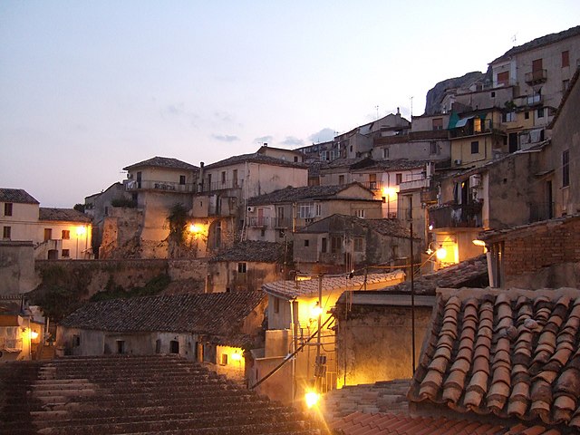
Спадола (Spadola, Spadola)
.svg)
- коммуна Италии
 Hiking in Спадола
Spadola is a charming small village located in the Calabria region of southern Italy, known for its stunning natural landscapes and mountainous terrain. Hiking in Spadola can provide an enriching experience, blending beautiful scenic views with cultural and historical elements.
Popular Hiking Trails:
-
Aspromonte National Park: Just a short drive from Spadola, this national park features numerous trails that lead through rugged mountains, deep gorges, and lush forests. Trails vary in difficulty, catering to both beginners and experienced hikers.
-
Monte Cocuzza: This is one of the peaks in the vicinity that offers a great hike with panoramic views of the surrounding area. The route can be challenging but is rewarding with breathtaking vistas at the summit.
-
Paths of Historical and Cultural Significance: Many trails around Spadola follow ancient paths which were once part of trade routes or connect various historical sites. These hikes allow you to explore both nature and the history of the region.
Tips for Hiking in Spadola:
-
Best Time to Hike: The ideal months for hiking in Spadola are from late spring to early autumn (May to October). The weather is usually pleasant, with cooler temperatures in the mountains.
-
Prepare for Varying Terrain: The terrain can be rugged and unpredictable; sturdy hiking shoes and a good backpack are essential.
-
Stay Hydrated: Always carry sufficient water, especially on warmer days.
-
Wildlife and Flora: Keep an eye out for local wildlife, such as birds and various plant species that are unique to the region.
-
Local Guides: Consider hiring a local guide who can provide insights into the trails and share knowledge about the local environment and culture.
Cultural Aspects:
While hiking, take the opportunity to visit local villages and engage with the community. You might discover local culinary specialties or traditional crafts that are part of the Calabria culture.
Safety Measures:
- Always inform someone of your hiking plans.
- Follow trail markers and signage to avoid getting lost.
- Check weather conditions before heading out.
Hiking in Spadola is a fantastic way to experience the beauty of Calabria's natural landscapes while also enjoying the rich culture and history of the region. Enjoy your adventure!
- Страна:

- Почтовый код: 89822
- Телефонный код: 0963
- Код автомобильного номера: VV
- Координаты: 38° 36' 0" N, 16° 20' 0" E


- GPS треки (wikiloc): [Ссылка]
- Высота над уровнем моря: 754 м m
- Площадь: 9.65 кв.км
- Население: 811
- Веб сайт: http://www.comune.spadola.vv.it/
- Википедия русская: wiki(ru)
- Википедия английская: wiki(en)
- Википедия национальная: wiki(it)
- Хранилище Wikidata: Wikidata: Q54744
- Катеория в википедии: [Ссылка]
- код Freebase: [/m/0gr7k5]
- код GeoNames: Альт: [6543837]
- ID отношения в OpenStreetMap: [39658]
- код ISTAT: 102041
- кадастровый код Италии: I884
Граничит с регионами:

Стило
- коммуна Италии
Hiking in Стило
Stilo, located in Calabria, Italy, is known for its beautiful landscapes, rich history, and diverse hiking opportunities. Here are some key points to consider if you're planning a hiking trip in Stilo:...
- Страна:
- Почтовый код: 89049
- Телефонный код: 0964
- Код автомобильного номера: RC
- Координаты: 38° 29' 0" N, 16° 28' 0" E
- GPS треки (wikiloc): [Ссылка]
- Высота над уровнем моря: 386 м m
- Площадь: 78.11 кв.км
- Население: 2573
- Веб сайт: [Ссылка]


Броньятуро
- коммуна Италии
Hiking in Броньятуро
Brognaturo is a charming village located in the Calabria region of southern Italy, nestled in the Serre Mountains. The area is characterized by its stunning natural scenery, rich biodiversity, and numerous hiking opportunities. Here are some key aspects to consider when hiking in Brognaturo:...
- Страна:
- Почтовый код: 89822
- Телефонный код: 0963
- Код автомобильного номера: VV
- Координаты: 38° 36' 0" N, 16° 20' 0" E
- GPS треки (wikiloc): [Ссылка]
- Высота над уровнем моря: 760 м m
- Площадь: 25.69 кв.км
- Население: 720
- Веб сайт: [Ссылка]
Джерокарне
- коммуна Италии
Hiking in Джерокарне
Gerocarne is a charming town located in the Calabria region of southern Italy. Although it may not be as widely known as other hiking destinations in Italy, it offers beautiful landscapes and a rich natural environment that can be explored through various hiking trails....
- Страна:
- Почтовый код: 89831
- Телефонный код: 0963
- Код автомобильного номера: VV
- Координаты: 38° 35' 0" N, 16° 13' 0" E
- GPS треки (wikiloc): [Ссылка]
- Высота над уровнем моря: 241 м m
- Площадь: 45.23 кв.км
- Население: 2146
- Веб сайт: [Ссылка]


Серра-Сан-Бруно
- коммуна Италии
Hiking in Серра-Сан-Бруно
Serra San Bruno, located in the Calabria region of southern Italy, is a beautiful area known for its stunning natural landscapes, rich history, and peaceful atmosphere. It's an excellent destination for hiking enthusiasts of all levels. Here are some key points to consider when hiking in the Serra San Bruno area:...
- Страна:
- Почтовый код: 89822
- Телефонный код: 0963
- Код автомобильного номера: VV
- Координаты: 38° 35' 0" N, 16° 20' 0" E
- GPS треки (wikiloc): [Ссылка]
- Высота над уровнем моря: 870 м m
- Площадь: 40.57 кв.км
- Население: 6604
- Веб сайт: [Ссылка]
Симбарио
- коммуна Италии
Hiking in Симбарио
Simbario, located in the Calabria region of southern Italy, offers a unique hiking experience characterized by its rugged terrain, natural beauty, and rich cultural heritage. Here are some highlights to consider when hiking in Simbario:...
- Страна:
- Почтовый код: 89822
- Телефонный код: 0963
- Код автомобильного номера: VV
- Координаты: 38° 37' 0" N, 16° 20' 0" E
- GPS треки (wikiloc): [Ссылка]
- Высота над уровнем моря: 766 м m
- Площадь: 20.83 кв.км
- Население: 957
- Веб сайт: [Ссылка]


Сорианелло
- коммуна Италии
Hiking in Сорианелло
Sorianello is a charming village located in the Calabria region of southern Italy, nestled in the Serre Calabresi mountains. This area is known for its stunning landscapes, rich biodiversity, and cultural heritage, making it an excellent destination for hiking enthusiasts....
- Страна:
- Почтовый код: 89831
- Телефонный код: 0963
- Код автомобильного номера: VV
- Координаты: 38° 36' 0" N, 16° 14' 0" E
- GPS треки (wikiloc): [Ссылка]
- Высота над уровнем моря: 420 м m
- Площадь: 9.59 кв.км
- Население: 1181
- Веб сайт: [Ссылка]