Шпайхер (Speicher, Speicher AR)

 Hiking in Шпайхер
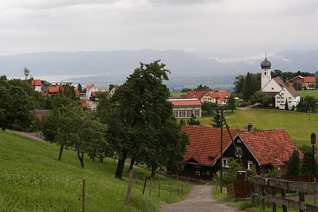
Speicher, located in the Appenzell Region of Switzerland, is an ideal destination for hiking enthusiasts. The area offers a picturesque blend of meadows, forests, and stunning mountain views. Here are some key highlights of hiking in Speicher:
Trails
-
Accessibility: The hiking trails in and around Speicher range from easy to moderate, making them suitable for hikers of varying skill levels. Trails are well-marked and maintained.
-
Scenic Routes: Many trails provide breathtaking views of the surrounding hills and the distant peaks of the Alps. The paths often wind through forests, past grazing cattle and traditional Swiss farmsteads.
-
Local Highlights:
- Zurichsee Trail: This trail provides stunning views of Lake Zurich along with the scenic backdrop of mountains.
- Appenzell Trail: Nearby trails lead to the Appenzell region, known for its appealing landscapes and traditional Swiss culture.
Nature and Wildlife
- Flora and Fauna: The hiking trails provide opportunities to see diverse flora, including Alpine flowers, and fauna such as chamois and various bird species. Wildlife watching can be a rewarding experience.
Tips for Hiking in Speicher
-
Best Times to Hike: The ideal hiking season is typically from late spring to early autumn (May to October) when the weather is milder and the trails are more accessible.
-
Equipment: Wear sturdy hiking boots and dress in layers to adapt to changing weather conditions. A good map or GPS device is also advisable.
-
Local Amenities: There are various places to stop for food and refreshments along the trails, either in Speicher itself or in nearby villages. Consider packing a picnic for a scenic meal.
-
Respect Nature: As always, follow Leave No Trace principles to preserve the beauty of the natural environment.
Transportation
Speicher is accessible via public transportation, and various trailheads can be reached easily from the town. Check local schedules for the best routes.
Safety
Always inform someone about your hiking plans, and check weather conditions before embarking on your hike. If you're unfamiliar with the area, consider joining a guided tour.
Overall, hiking in Speicher offers a wonderful way to experience Switzerland's natural beauty and charming rural landscape. Whether you're looking for a leisurely stroll or a more challenging hike, you'll find plenty of options in this idyllic region.
- Страна:

- Почтовый код: 9042
- Телефонный код: 071
- Код автомобильного номера: AR
- Координаты: 47° 24' 38" N, 9° 26' 36" E


- GPS треки (wikiloc): [Ссылка]
- Высота над уровнем моря: 936 м m
- Площадь: 8.17 кв.км
- Население: 4293
- Веб сайт: http://www.speicher.ch
- Википедия русская: wiki(ru)
- Википедия английская: wiki(en)
- Википедия национальная: wiki(de)
- Хранилище Wikidata: Wikidata: Q67148
- Катеория в википедии: [Ссылка]
- код Freebase: [/m/01v682]
- код GeoNames: Альт: [7287203]
- код VIAF: Альт: [5033147270698235700008]
- ID отношения в OpenStreetMap: [1683940]
- идентификатор HDS: [1302]
- код швейцарского муниципалитета: [3023]
Граничит с регионами:


Санкт-Галлен
- община в Швейцарии, Санкт-Галлен
Hiking in Санкт-Галлен
St. Gallen, located in the northeastern part of Switzerland, is an excellent destination for hiking enthusiasts. The region is characterized by stunning landscapes, including rolling hills, lush forests, and panoramic mountain views. Here are some highlights of hiking in and around St. Gallen:...
- Страна:
- Почтовый код: 9000
- Телефонный код: 071
- Код автомобильного номера: SG
- Координаты: 47° 25' 24" N, 9° 22' 38" E
- GPS треки (wikiloc): [Ссылка]
- Высота над уровнем моря: 675 м m
- Площадь: 39.41 кв.км
- Население: 75481
- Веб сайт: [Ссылка]

Эггерсрит
Hiking in Эггерсрит
Eggersriet is a charming little town located in the canton of St. Gallen, Switzerland, nestled amidst beautiful landscapes. Hiking in and around Eggersriet allows you to enjoy breathtaking views of the surrounding hills, forests, and rural scenery....
- Страна:
- Почтовый код: 9034
- Телефонный код: 071
- Код автомобильного номера: SG
- Координаты: 47° 26' 59" N, 9° 27' 59" E
- GPS треки (wikiloc): [Ссылка]
- Высота над уровнем моря: 817 м m
- Площадь: 8.82 кв.км
- Население: 2275
- Веб сайт: [Ссылка]


Реэтобель
Hiking in Реэтобель
Rehetobel is a scenic area located in the canton of Appenzell in Switzerland, known for its picturesque landscapes and hiking opportunities. Here are some highlights and tips for hiking in Rehetobel:...
- Страна:
- Почтовый код: 9038
- Телефонный код: 071
- Код автомобильного номера: AR
- Координаты: 47° 25' 40" N, 9° 28' 54" E
- GPS треки (wikiloc): [Ссылка]
- Высота над уровнем моря: 940 м m
- Площадь: 6.72 кв.км
- Население: 1750
- Веб сайт: [Ссылка]


Бюлер
Hiking in Бюлер
Bühler is a beautiful area known for its stunning landscapes and hiking opportunities. Whether you're looking for leisurely walks or more challenging trails, Bühler offers a variety of options for outdoor enthusiasts....
- Страна:
- Почтовый код: 9055
- Телефонный код: 071
- Код автомобильного номера: AR
- Координаты: 47° 22' 22" N, 9° 25' 16" E
- GPS треки (wikiloc): [Ссылка]
- Высота над уровнем моря: 824 м m
- Площадь: 5.61 кв.км
- Население: 1766
- Веб сайт: [Ссылка]


Тойфен
Hiking in Тойфен
Teufen, located in Appenzell Ausserrhoden, Switzerland, offers a stunning setting for hiking enthusiasts. The region is characterized by beautiful meadows, rolling hills, and breathtaking views of the Appenzell Alps. Here are some highlights of hiking in this area:...
- Страна:
- Почтовый код: 9053
- Телефонный код: 071
- Код автомобильного номера: AR
- Координаты: 47° 23' 37" N, 9° 23' 19" E
- GPS треки (wikiloc): [Ссылка]
- Высота над уровнем моря: 875 м m
- Площадь: 15.3 кв.км
- Население: 6267
- Веб сайт: [Ссылка]

Троген
Hiking in Троген
Trogen is a charming village located in the Appenzell region of Switzerland, surrounded by beautiful landscapes, rolling hills, and stunning views of the Alps. The area is known for its varied hiking trails that cater to all levels of experience, making it an excellent destination for both novice and experienced hikers....
- Страна:
- Почтовый код: 9043
- Телефонный код: 071
- Код автомобильного номера: AR
- Координаты: 47° 24' 27" N, 9° 27' 53" E
- GPS треки (wikiloc): [Ссылка]
- Высота над уровнем моря: 903 м m
- Площадь: 10.02 кв.км
- Население: 1721
- Веб сайт: [Ссылка]