Шпиталь-ам-Земмеринг (Spital am Semmering, Spital am Semmering)
 Hiking in Шпиталь-ам-Земмеринг
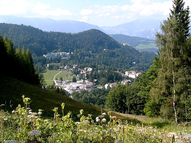
Spital am Semmering is a picturesque village located in the Styrian region of Austria, surrounded by stunning mountain scenery, making it an excellent destination for hiking enthusiasts. Here are some highlights and tips for hiking in this beautiful area:
1.
- Semmering Railway: The area is famous for its historic Semmering Railway, which is a UNESCO World Heritage site. Some hiking trails offer views of this stunning engineering feat along with the surrounding landscapes.
- Hiking Routes: Various marked trails cater to different levels of hikers. You can find easy trails suitable for families, as well as more challenging hikes for experienced trekkers.
- Routes to Explore: Look for paths leading to local landmarks such as the Kieneck peak, which offers stunning panoramic views over the region.
2.
- The region boasts lush forests, alpine meadows, and diverse wildlife. Keep an eye out for local flora and fauna, and enjoy the tranquility that nature offers.
- Many trails are lined with informational signs about the local ecosystem and geology, enhancing your hiking experience.
3.
- Access: Spital am Semmering is accessible by car and has connections via public transport. Many trails are well-marked, helping you navigate easily.
- Facilities: There are picnic areas, rest points, and sometimes small alpine huts (Almhütten) where you can grab a snack or a drink.
4.
- Summer: This is the prime hiking season, with mild weather and full access to all trails.
- Autumn: Fall foliage adds stunning colors to the landscape, making hikes particularly beautiful during this time.
- Winter: Although less common for traditional hiking, winter sports such as snowshoeing and skiing are available in the area.
5.
- Gear: Wear suitable hiking shoes, and bring layers of clothing as the weather can change rapidly in the mountains. Don't forget your hydration pack!
- Navigation: While trails are marked, consider carrying a map or downloading a hiking app for offline navigation.
- Respect Nature: Stay on marked paths, take your trash with you, and respect wildlife and plants.
6.
- Take time to explore Spital am Semmering beyond hiking. Enjoy local cuisine at restaurants, and immerse yourself in the friendly atmosphere of this charming village.
Whether you're seeking a challenging hike or a leisurely stroll through nature, Spital am Semmering has something to offer for every hiking enthusiast. Enjoy your adventure!
- Страна:

- Почтовый код: 8684
- Телефонный код: 03853
- Код автомобильного номера: MZ
- Координаты: 47° 36' 58" N, 15° 45' 14" E


- GPS треки (wikiloc): [Ссылка]
- Высота над уровнем моря: 800 м m
- Площадь: 72.59 кв.км
- Население: 1595
- Веб сайт: http://www.spitalamsemmering.com
- Википедия русская: wiki(ru)
- Википедия английская: wiki(en)
- Википедия национальная: wiki(de)
- Хранилище Wikidata: Wikidata: Q176887
- Катеория в википедии: [Ссылка]
- код Freebase: [/m/03gwk6v]
- код GeoNames: Альт: [2764788]
- код VIAF: Альт: [245815795]
- идентификатор местоположения ArchINFORM: [10487]
- код австрийского муниципалитета: [62131]
Граничит с регионами:


Реттенег
Hiking in Реттенег
Rettenegg is a beautiful area located in Styria, Austria, known for its stunning landscapes and diverse hiking opportunities. Nestled in the foothills of the Eastern Alps, it offers a unique blend of lush forests, serene meadows, and panoramic mountain views....
- Страна:
- Почтовый код: 8674
- Телефонный код: 03173
- Код автомобильного номера: WZ
- Координаты: 47° 31' 33" N, 15° 46' 49" E
- GPS треки (wikiloc): [Ссылка]
- Высота над уровнем моря: 862 м m
- Площадь: 78.87 кв.км
- Население: 741
- Веб сайт: [Ссылка]

Брайтенштайн
Hiking in Брайтенштайн
Breitenstein is a charming area in Lower Austria, known for its beautiful landscapes, hiking trails, and scenic views of the surrounding alpine terrain. Here's what you need to know about hiking in the region:...
- Страна:
- Телефонный код: 02664
- Код автомобильного номера: NK
- Координаты: 47° 39' 41" N, 15° 49' 27" E
- GPS треки (wikiloc): [Ссылка]
- Высота над уровнем моря: 779 м m
- Площадь: 20.29 кв.км
- Население: 318
- Веб сайт: [Ссылка]


Мюрццушлаг
- муниципалитет в Австрии
Hiking in Мюрццушлаг
Mürzzuschlag, located in the heart of Styria, Austria, is a wonderful destination for hiking enthusiasts. Surrounded by the stunning landscape of the Alps, the region offers a variety of trails catering to all skill levels, from leisurely walks to challenging mountain hikes....
- Страна:
- Почтовый код: 8680
- Телефонный код: 03852
- Код автомобильного номера: MZ
- Координаты: 47° 36' 27" N, 15° 40' 23" E
- GPS треки (wikiloc): [Ссылка]
- Высота над уровнем моря: 670 м m
- Площадь: 12.26 кв.км
- Население: 8681
- Веб сайт: [Ссылка]
Земмеринг
- коммуна в земле Нижняя Австрия
Hiking in Земмеринг
Semmering, Austria, is a popular hiking destination known for its stunning landscapes, diverse trails, and rich cultural history. Nestled in the Eastern Alps, it offers a mix of challenging hikes and family-friendly options, making it suitable for hikers of all levels....
- Страна:
- Почтовый код: 2680
- Телефонный код: 02664
- Код автомобильного номера: NK
- Координаты: 47° 37' 0" N, 15° 49' 0" E
- GPS треки (wikiloc): [Ссылка]
- Высота над уровнем моря: 985 м m
- Площадь: 8.66 кв.км
- Население: 577
- Веб сайт: [Ссылка]

Райхенау-ан-дер-Ракс
- ярмарочная коммуна в земле Нижняя Австрия
Hiking in Райхенау-ан-дер-Ракс
Reichenau an der Rax, located in Austria, is a stunning destination for hiking enthusiasts, offering a variety of trails that cater to different skill levels and preferences. Nestled in the Rax-Schneeberg region, Reichenau provides breathtaking views of the surrounding mountains and valleys, making it a popular spot for both casual walkers and seasoned hikers....
- Страна:
- Почтовый код: 2651, 2654
- Телефонный код: 02666
- Код автомобильного номера: NK
- Координаты: 47° 42' 0" N, 15° 50' 0" E
- GPS треки (wikiloc): [Ссылка]
- Высота над уровнем моря: 484 м m
- Площадь: 89.5 кв.км
- Население: 2601
- Веб сайт: [Ссылка]

Шотвин
Hiking in Шотвин
Schottwien is a charming village located in the Lower Austria region of Austria, surrounded by beautiful natural landscapes that offer numerous hiking opportunities. Here are some highlights and tips for hiking in and around Schottwien:...
- Страна:
- Почтовый код: 2641, 2642
- Телефонный код: 02663
- Код автомобильного номера: NK
- Координаты: 47° 38' 0" N, 15° 52' 0" E
- GPS треки (wikiloc): [Ссылка]
- Высота над уровнем моря: 569 м m
- Площадь: 12.52 кв.км
- Население: 660
- Веб сайт: [Ссылка]
Траттенбах
Hiking in Траттенбах
Trattenbach, located in Austria, is surrounded by beautiful natural landscapes, making it a great destination for hiking enthusiasts. The region is characterized by lush forests, rolling hills, and clear streams, providing a variety of trails suitable for different skill levels....
- Страна:
- Почтовый код: 2881
- Телефонный код: 02641
- Код автомобильного номера: NK
- Координаты: 47° 35' 43" N, 15° 53' 13" E
- GPS треки (wikiloc): [Ссылка]
- Высота над уровнем моря: 777 м m
- Площадь: 30.91 кв.км
- Население: 545
- Веб сайт: [Ссылка]

Нойберг-ан-дер-Мюрц
Hiking in Нойберг-ан-дер-Мюрц
Neuberg an der Mürz is a charming town located in Styria, Austria, surrounded by beautiful mountainous landscapes, making it an excellent destination for hiking enthusiasts. Here are some highlights and considerations for hiking in this area:...
- Страна:
- Телефонный код: 03857
- Код автомобильного номера: MZ
- Координаты: 47° 40' 1" N, 15° 34' 30" E
- GPS треки (wikiloc): [Ссылка]
- Высота над уровнем моря: 732 м m
- Площадь: 63.98 кв.км
- Население: 2494
- Веб сайт: [Ссылка]