
Шпитталь-ан-дер-Драу (Spittal an der Drau, Spittal an der Drau)
 Hiking in Шпитталь-ан-дер-Драу
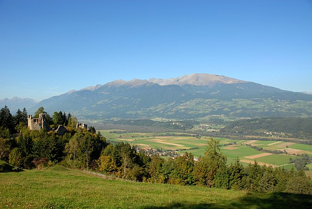
Spittal an der Drau, located in Carinthia, Austria, is an excellent destination for hiking enthusiasts. Nestled in a picturesque valley with stunning alpine scenery, it offers a variety of trails suitable for different skill levels, from leisurely walks to more challenging hikes.
Key Hiking Routes and Areas:
-
Drauradweg: This scenic bike and walking path follows the Drau River and offers easy access for families and less experienced hikers. It's perfect for a leisurely stroll while enjoying the beautiful riverscapes.
-
Goldeck Mountain: The area surrounding Goldeck provides several hiking trails with breathtaking views of the surrounding Alps. The summit can be reached by a cable car, and from there, you can explore numerous paths offering panoramic vistas.
-
Nockberge Biosphere Reserve: Just a short drive from Spittal, the Nockberge region features well-marked trails through unique landscapes, including rolling green hills, clear lakes, and rich biodiversity. It’s an excellent area for both hiking and wildlife watching.
-
Nationalpark Hohe Tauern: A bit farther afield, but definitely worth the trip, this national park is known for its stunning mountain scenery, waterfalls, and diverse flora and fauna. There are numerous trails that allow you to explore this breathtaking area.
Tips for Hiking in Spittal an der Drau:
-
Season Considerations: Late spring to early fall is the best time to hike, with various trails accessible during this period. However, some high-altitude trails may still be snow-covered in early summer.
-
Gear Up: Make sure you have appropriate hiking footwear, weather-appropriate clothing, and enough water and snacks. Weather can change quickly in the mountains.
-
Local Information: Check in at local tourist information centers for maps, conditions, and tips on the best trails for your skill level.
-
Caution and Respect: Always stay on marked trails, follow local regulations, and respect nature.
Spittal an der Drau is not only beautiful but also offers ample opportunities for hiking and immersing yourself in nature, making it an ideal spot for outdoor activities.
- Страна:

- Код автомобильного номера: SP
- Координаты: 46° 47' 30" N, 13° 29' 45" E


- GPS треки (wikiloc): [Ссылка]
- Высота над уровнем моря: 560 м m
- Площадь: 48.51 кв.км
- Население: 15413
- Веб сайт: http://www.spittal-drau.at
- Википедия русская: wiki(ru)
- Википедия английская: wiki(en)
- Википедия национальная: wiki(de)
- Хранилище Wikidata: Wikidata: Q487500
- Галерея изображений в википедии: [Ссылка]
- Катеория в википедии: [Ссылка]
- код Freebase: [/m/0502z4]
- код GeoNames: Альт: [2764786]
- код BNF: [11969756t]
- код VIAF: Альт: [137348215]
- код GND: Альт: [4105484-2]
- идентификатор местоположения ArchINFORM: [10486]
- код LCNAF: Альт: [n92060323]
- место в MusicBrainz: [e860ca38-afd6-482c-9026-d744d828ed08]
- WOEID: [12673582]
- код австрийского муниципалитета: [20635]
Граничит с регионами:

Штоккенбой
Hiking in Штоккенбой
Stockenboi is a beautiful location in Austria, nestled in the stunning landscape of Carinthia. The area is renowned for its outdoor activities, including hiking, which offers a mix of picturesque views, tranquil forests, and a variety of trails catering to different skill levels....
- Страна:
- Почтовый код: 9714
- Телефонный код: 0 47 61
- Код автомобильного номера: VL
- Координаты: 46° 43' 45" N, 13° 34' 50" E
- GPS треки (wikiloc): [Ссылка]
- Высота над уровнем моря: 795 м m
- Площадь: 100.18 кв.км
- Население: 1604
- Веб сайт: [Ссылка]

Зеебоден
Hiking in Зеебоден
Seeboden is a picturesque town located in Austria’s Carinthia region, nestled at the northern shore of Lake Millstatt (Millstätter See). This area is known for its stunning landscapes, beautiful lakes, and scenic mountains, making it an excellent destination for hiking enthusiasts of all skill levels....
- Страна:
- Почтовый код: 9871
- Телефонный код: 04762
- Код автомобильного номера: SP
- Координаты: 46° 49' 8" N, 13° 31' 6" E
- GPS треки (wikiloc): [Ссылка]
- Высота над уровнем моря: 618 м m
- Площадь: 44.41 кв.км
- Население: 6418
- Веб сайт: [Ссылка]
Бальдрамсдорф
Hiking in Бальдрамсдорф
Baldramsdorf is a picturesque village located in the Carinthia region of Austria, surrounded by the stunning landscapes of the Alps. It offers a variety of hiking opportunities suitable for all skill levels, making it a great destination for outdoor enthusiasts....
- Страна:
- Почтовый код: 9805
- Телефонный код: 0 47 62
- Код автомобильного номера: SP
- Координаты: 46° 48' 4" N, 13° 27' 12" E
- GPS треки (wikiloc): [Ссылка]
- Высота над уровнем моря: 584 м m
- Площадь: 37.95 кв.км
- Население: 1866
- Веб сайт: [Ссылка]

Ферндорф
Hiking in Ферндорф
Ferndorf, located in Austria, is a beautiful destination for hiking enthusiasts. Nestled in the picturesque landscape of Carinthia, Ferndorf offers a variety of trails that cater to different skill levels, from easy family-friendly walks to more challenging mountain hikes....
- Страна:
- Почтовый код: 9702
- Телефонный код: 0 42 45
- Код автомобильного номера: VL
- Координаты: 46° 44' 10" N, 13° 37' 35" E
- GPS треки (wikiloc): [Ссылка]
- Высота над уровнем моря: 560 м m
- Площадь: 31.41 кв.км
- Население: 2156
- Веб сайт: [Ссылка]
Лендорф
Hiking in Лендорф
Lendorf, located in Austria, is a beautiful destination for hiking enthusiasts. Nestled in the Carinthia region, it offers a stunning landscape characterized by rolling hills, lush forests, and panoramic views of the surrounding mountains. Here are some key points to consider when hiking in Lendorf:...
- Страна:
- Почтовый код: 9811
- Телефонный код: 0 47 62
- Код автомобильного номера: SP
- Координаты: 46° 50' 0" N, 13° 25' 0" E
- GPS треки (wikiloc): [Ссылка]
- Высота над уровнем моря: 584 м m
- Площадь: 34.3 кв.км
- Население: 1712
- Веб сайт: [Ссылка]

Мильстат
Hiking in Мильстат
Millstatt, located in the beautiful Carinthia region of Austria, is a fantastic destination for hiking enthusiasts. The area is known for its stunning landscapes, including panoramic views of the surrounding mountains and the serene Millstätter See (Lake Millstatt)....
- Страна:
- Почтовый код: 9872
- Телефонный код: 04766
- Код автомобильного номера: SP
- Координаты: 46° 48' 15" N, 13° 34' 50" E
- GPS треки (wikiloc): [Ссылка]
- Высота над уровнем моря: 611 м m
- Площадь: 57.74 кв.км
- Население: 3460
- Веб сайт: [Ссылка]