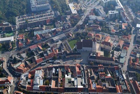
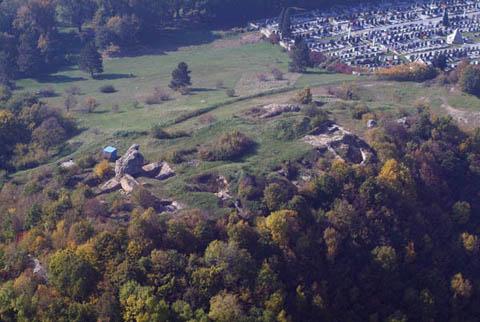
Штоцинг (Stotzing, Stotzing)
 Hiking in Штоцинг
While I don't have specific details on hiking in Stotzing, I can provide some general advice on how to approach hiking in smaller or lesser-known areas while also encouraging exploration of scenic and beautiful trails. If Stotzing is a destination you're considering, here are a few tips for a successful hiking experience:
-
Research Trails: Look for local hiking trails using apps like AllTrails, or check with local outdoor shops or visitor centers for maps and recommendations. They often provide information on trail lengths, difficulty levels, and sights along the way.
-
Know the Terrain: Understand the type of terrain you’ll be hiking. In less-known regions, trails can vary significantly in elevation and difficulty. Make sure you choose a trail that fits your experience level.
-
Safety First: Always inform someone of your hiking plans, especially in remote areas. Carry a first-aid kit, plenty of water, snacks, and a fully charged phone for emergencies.
-
Check the Weather: Mountain weather can change rapidly. Be prepared for different conditions, and make sure to check the forecast before you head out.
-
Leave No Trace: When hiking in nature, it's important to follow the Leave No Trace principles. Stay on marked trails, pack out what you pack in, and respect wildlife and plants.
-
Local Insights: If you can, connect with local hiking groups or outdoor enthusiasts in the area. They can provide invaluable insights and possibly guide you to hidden gems.
If you have specific details or features of the Stotzing area you're interested in (e.g., specific trails, landmarks, or natural features), feel free to share, and I can provide more tailored advice!
- Страна:

- Почтовый код: 2443
- Телефонный код: 02255
- Код автомобильного номера: EU
- Координаты: 47° 54' 25" N, 16° 32' 38" E


- GPS треки (wikiloc): [Ссылка]
- Высота над уровнем моря: 253 м m
- Площадь: 12.91 кв.км
- Население: 840
- Веб сайт: http://www.stotzing.at
- Википедия русская: wiki(ru)
- Википедия английская: wiki(en)
- Википедия национальная: wiki(de)
- Хранилище Wikidata: Wikidata: Q592578
- Катеория в википедии: [Ссылка]
- код Freebase: [/m/02qmyb4]
- код GeoNames: Альт: [2764225]
- код VIAF: Альт: [248577203]
- код GND: Альт: [4118835-4]
- WOEID: [539070]
- код австрийского муниципалитета: [10321]
Граничит с регионами:
Айзенштадт
- город в Австрии
Hiking in Айзенштадт
Eisenstadt, the capital of Burgenland in Austria, offers several hiking opportunities that showcase its beautiful natural landscapes, historical sites, and charming vineyards. Here are some highlights for hiking in and around Eisenstadt:...
- Страна:
- Почтовый код: 7000
- Телефонный код: 02682
- Код автомобильного номера: E
- Координаты: 47° 50' 44" N, 16° 31' 8" E
- GPS треки (wikiloc): [Ссылка]
- Высота над уровнем моря: 182 м m
- Площадь: 42.84 кв.км
- Население: 14476
- Веб сайт: [Ссылка]
Лоретто
Hiking in Лоретто
Loretto, a small village located in the vicinity of the city of Linz in Austria, offers some charming hiking opportunities. While Loretto itself may not be a major hiking destination, the surrounding area boasts beautiful trails that cater to various skill levels. Here are some highlights and tips for hiking in and around Loretto:...
- Страна:
- Почтовый код: 2443
- Телефонный код: 02255
- Код автомобильного номера: EU
- Координаты: 47° 54' 55" N, 16° 31' 1" E
- GPS треки (wikiloc): [Ссылка]
- Высота над уровнем моря: 218 м m
- Площадь: 23.8 кв.км
- Население: 400
- Веб сайт: [Ссылка]

Лайтапродерсдорф
Hiking in Лайтапродерсдорф
Leithaprodersdorf is a small village located in the Burgenland region of Austria, known for its beautiful natural landscapes and outdoor activities, including hiking. Hiking opportunities in and around Leithaprodersdorf typically feature scenic trails that meander through picturesque vineyards, rolling hills, and lush farmlands....
- Страна:
- Почтовый код: 2443
- Телефонный код: 02255
- Код автомобильного номера: EU
- Координаты: 47° 56' 16" N, 16° 28' 43" E
- GPS треки (wikiloc): [Ссылка]
- Высота над уровнем моря: 196 м m
- Площадь: 18.9 кв.км
- Население: 1193
- Веб сайт: [Ссылка]
Хорнштайн
Hiking in Хорнштайн
Hornstein, located in the Burgenland region of Austria, offers a range of hiking opportunities that combine picturesque landscapes with cultural experiences. Here are some key points to consider when planning a hiking trip in Hornstein:...
- Страна:
- Почтовый код: 2491, 7053
- Телефонный код: 02689
- Код автомобильного номера: EU
- Координаты: 47° 52' 51" N, 16° 26' 44" E
- GPS треки (wikiloc): [Ссылка]
- Высота над уровнем моря: 273 м m
- Площадь: 37.07 кв.км
- Население: 3012
- Веб сайт: [Ссылка]

Ослип
Hiking in Ослип
Oslip, a charming village located in Austria's Burgenland region, offers scenic landscapes and a pleasant environment for hiking enthusiasts. The area is characterized by rolling hills, vineyards, and picturesque countryside, making it an excellent destination for outdoor activities....
- Страна:
- Почтовый код: 7064
- Телефонный код: 02684
- Код автомобильного номера: EU
- Координаты: 47° 49' 45" N, 16° 37' 8" E
- GPS треки (wikiloc): [Ссылка]
- Высота над уровнем моря: 127 м m
- Площадь: 17.83 кв.км
- Население: 1243
- Веб сайт: [Ссылка]

Ау-ам-Лайтаберге
Hiking in Ау-ам-Лайтаберге
Au am Leithaberge is a beautiful area located in Austria, near the Leithaberg mountain range. This region offers a variety of hiking opportunities that cater to different skill levels and preferences. Here are some key aspects you can consider for hiking in Au am Leithaberge:...
- Страна:
- Почтовый код: 2451
- Телефонный код: 02168
- Код автомобильного номера: BL
- Координаты: 47° 55' 0" N, 16° 33' 0" E
- GPS треки (wikiloc): [Ссылка]
- Высота над уровнем моря: 211 м m
- Площадь: 16.74 кв.км
- Население: 945
- Веб сайт: [Ссылка]