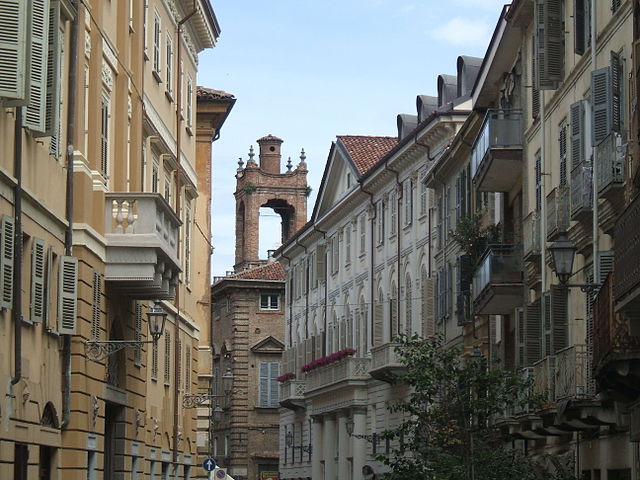
Терруджа (Terruggia, Terruggia)
- коммуна в регионе Пьемонт, Италия
 Hiking in Терруджа
Terruggia is a small municipality located in the Piedmont region of Italy, in the province of Alessandria. While it may not be as widely recognized as some of the larger hiking destinations in Italy, it offers a charming setting for those looking to explore the outdoors.
Hiking Opportunities in Terruggia
-
Scenic Trails: The area around Terruggia features various trails that meander through the beautiful Piedmont countryside, with vineyards, rustic farms, and picturesque landscapes that reflect the region's rich agricultural heritage.
-
Nature and Wildlife: The surrounding countryside is home to diverse flora and fauna. Along the trails, you might encounter local wildlife, especially if you venture into the more protected areas and forests.
-
Nearby Natural Parks: While Terruggia itself has limited hiking paths, there are several natural parks and recreational areas within a short drive. The nearby Monferrato region offers a range of hiking trails that vary in difficulty and length, allowing for both leisurely walks and more challenging hikes.
-
Cultural Exploration: Hiking in this area also provides an opportunity to discover local history and culture. You can explore ancient ruins, small chapels, and traditional rural architecture along the way.
Tips for Hiking in Terruggia
-
Plan Ahead: Since Terruggia is a smaller municipality, it’s advisable to check local maps and guides. Look for information on the best trails and whether they are marked well.
-
Weather Considerations: The weather can change, so always check the forecast before heading out. Spring and early fall are ideal times for hiking due to mild temperatures.
-
Hydration and Snacks: Carry enough water and snacks, particularly if you plan on spending several hours on the trails.
-
Appropriate Gear: Wear sturdy hiking shoes and dress in layers, especially if hiking in the cooler months.
-
Local Guidance: Consider reaching out to local hiking clubs or visitor centers for advice on trails and guided hikes that may be available.
In summary, while Terruggia might not be a well-known hiking hotspot, it offers beautiful landscapes and opportunities to explore the rural charm of the Piedmont region. Planning and allowing yourself time to enjoy the natural beauty can lead to a rewarding hiking experience.
- Страна:

- Почтовый код: 15030
- Телефонный код: 0142
- Код автомобильного номера: AL
- Координаты: 45° 5' 0" N, 8° 26' 39" E


- GPS треки (wikiloc): [Ссылка]
- Высота над уровнем моря: 199 м m
- Площадь: 7.27 кв.км
- Население: 932
- Веб сайт: http://www.comune.terruggia.al.it/
- Википедия русская: wiki(ru)
- Википедия английская: wiki(en)
- Википедия национальная: wiki(it)
- Хранилище Wikidata: Wikidata: Q17683
- Катеория в википедии: [Ссылка]
- код Freebase: [/m/0gbp7v]
- код GeoNames: Альт: [6536451]
- ID отношения в OpenStreetMap: [44192]
- код TGN: [7038610]
- UN/LOCODE: [ITTRR]
- код ISTAT: 006171
- кадастровый код Италии: L139
Граничит с регионами:
Казале-Монферрато
- город в регионе Пьемонт, Италия
Hiking in Казале-Монферрато
Casale Monferrato, located in the Piedmont region of Italy, offers beautiful landscapes and a rich cultural heritage, making it an appealing destination for hiking enthusiasts. Here are some highlights about hiking in the area:...
- Страна:
- Почтовый код: 15033
- Телефонный код: 0142
- Код автомобильного номера: AL
- Координаты: 45° 8' 3" N, 8° 27' 30" E
- GPS треки (wikiloc): [Ссылка]
- Высота над уровнем моря: 116 м m
- Площадь: 86.21 кв.км
- Население: 34010
- Веб сайт: [Ссылка]

Розиньяно-Монферрато
- коммуна в регионе Пьемонт, Италия
Hiking in Розиньяно-Монферрато
Rosignano Monferrato, located in the Piedmont region of Italy, is a charming village that offers a variety of hiking opportunities amidst beautiful landscapes, rolling hills, vineyards, and historical sites. Here are some key points to consider if you're interested in hiking in this area:...
- Страна:
- Почтовый код: 15030
- Телефонный код: 0142
- Код автомобильного номера: AL
- Координаты: 45° 4' 53" N, 8° 24' 3" E
- GPS треки (wikiloc): [Ссылка]
- Высота над уровнем моря: 280 м m
- Площадь: 19.28 кв.км
- Население: 1535
- Веб сайт: [Ссылка]