Терцолас (Terzolas, Terzolas)
%202018.svg)
- коммуна Италии
 Hiking in Терцолас
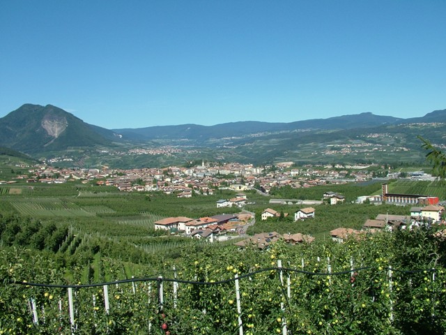
Terzolas is a charming village located in the Trentino region of northern Italy, surrounded by beautiful landscapes and offering a variety of hiking opportunities. Situated near the Val di Non, Terzolas provides access to several trails that cater to different skill levels.
Hiking Opportunities:
-
Local Trails:
- Many trails start right from Terzolas or nearby, winding through the lush forests and meadows. These paths often showcase the natural beauty of the area, including stunning views of the Brenta Dolomites.
-
Val di Non:
- This valley is known for its apple orchards and picturesque scenery. You can find numerous hiking routes, including those that lead to waterfalls and viewpoints overlooking the valley.
-
Monte Roen:
- A popular hike for more experienced hikers, the trails leading up to Monte Roen offer breathtaking panoramic views of the surrounding mountains and valleys. The climb can be moderately challenging and is ideal for those looking for a rewarding hike.
-
Lake Tret:
- A lovely destination accessible via hiking trails, Lake Tret offers opportunities for a scenic day hike along its shores or to the surrounding peaks.
Tips for Hiking in Terzolas:
- Check the Weather: The weather can change rapidly in the mountains, so it’s essential to check forecasts and be prepared for rain or cooler temperatures.
- Trail Maps: Utilize local trail maps or apps to navigate and choose the paths that best match your skill level and time.
- Pack Accordingly: Bring plenty of water, snacks, a first aid kit, and sun protection. Good hiking footwear is crucial for rugged trails.
- Respect Nature: Stick to marked paths and leave no trace to preserve the natural beauty for others.
Other Activities:
Aside from hiking, Terzolas is a great location for cycling, outdoor sports, and exploring local culture and gastronomy. Take some time to also explore the village and enjoy regional specialties.
Enjoy your hiking adventure in Terzolas! If you have specific trails or areas you'd like to know more about, feel free to ask!
- Страна:

- Почтовый код: 38027
- Телефонный код: 0463
- Код автомобильного номера: TN
- Координаты: 46° 21' 41" N, 10° 55' 34" E


- GPS треки (wikiloc): [Ссылка]
- Высота над уровнем моря: 755 м m
- Площадь: 5.59 кв.км
- Население: 638
- Веб сайт: http://www.visitterzolas.it
- Википедия русская: wiki(ru)
- Википедия английская: wiki(en)
- Википедия национальная: wiki(it)
- Хранилище Wikidata: Wikidata: Q327111
- Катеория в википедии: [Ссылка]
- код Freebase: [/m/0gb0zj]
- код GeoNames: Альт: [6542693]
- ID отношения в OpenStreetMap: [47134]
- код ISTAT: 022195
- кадастровый код Италии: L145
Граничит с регионами:


Кальдес
- коммуна Италии
Hiking in Кальдес
Caldes, a picturesque area in northern Italy, particularly known for its thermal springs, offers a variety of hiking opportunities that cater to different skill levels. Situated near the stunning Dolomites and surrounded by beautiful landscapes, hiking in Caldes allows you to experience both natural beauty and cultural heritage....
- Страна:
- Почтовый код: 38022
- Телефонный код: 0463
- Код автомобильного номера: TN
- Координаты: 46° 22' 0" N, 10° 57' 0" E
- GPS треки (wikiloc): [Ссылка]
- Высота над уровнем моря: 697 м m
- Площадь: 20.81 кв.км
- Население: 1089
- Веб сайт: [Ссылка]

Клес
- коммуна Италии
Hiking in Клес
Cles, located in the Trentino region of northern Italy, is a beautiful destination for hiking enthusiasts. Nestled in the Val di Non, it offers a variety of trails that cater to different skill levels, from easy walks to more challenging hikes. Here are some highlights of hiking in and around Cles:...
- Страна:
- Почтовый код: 38023
- Телефонный код: 0463
- Код автомобильного номера: TN
- Координаты: 46° 22' 0" N, 11° 2' 0" E
- GPS треки (wikiloc): [Ссылка]
- Высота над уровнем моря: 656 м m
- Площадь: 39.17 кв.км
- Население: 7009
- Веб сайт: [Ссылка]


Мале
- коммуна Италии
Hiking in Мале
Malé, located in the Val di Sole region of Trentino, Italy, is a charming town that serves as a gateway to various hiking opportunities in the surrounding mountains. The area is known for its stunning landscapes, rich flora and fauna, and a mix of trails suitable for different skill levels, making it a popular destination for hikers....
- Страна:
- Почтовый код: 38027
- Телефонный код: 0463
- Код автомобильного номера: TN
- Координаты: 46° 21' 13" N, 10° 54' 45" E
- GPS треки (wikiloc): [Ссылка]
- Высота над уровнем моря: 737 м m
- Площадь: 26.53 кв.км
- Население: 2145
- Веб сайт: [Ссылка]