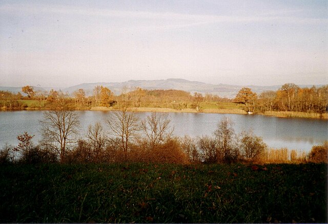
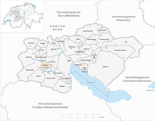
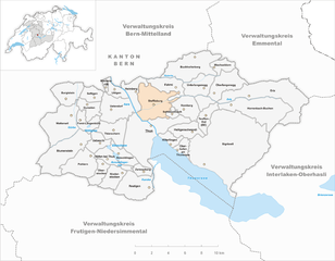
Тун (Thun administrative district, Verwaltungskreis Thun)

- административный округ кантона Берн
 Hiking in Тун
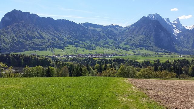
Thun, located in the Bernese Oberland region of Switzerland, is a beautiful area known for its stunning landscapes, charming town, and access to numerous hiking trails. The administrative district is situated at the shores of Lake Thun, with the picturesque backdrop of the Alps, making it a popular destination for hikers of all levels.
Key Hiking Areas in Thun:
-
Niesen Mountain: Sometimes referred to as the "Swiss Pyramid," Niesen offers spectacular views of Lake Thun and the surrounding landscapes. The hike to the summit is well-marked and provides a rewarding experience, especially for those who make it to the top.
-
Stockhorn: This mountain offers a variety of hiking routes, including both easier walks and more strenuous climbs. The Stockhorn cable car can take you partway up, allowing hikers to enjoy trails with breathtaking panoramas without needing to climb all the way.
-
Thunersee (Lake Thun) Promenade: For a more relaxed experience, the lakeside walking paths around Lake Thun offer gentle hikes with stunning water views, charming villages, and picnic spots along the way.
-
Schwarzsee and the Gantrisch region: Located slightly further afield, these areas offer a variety of marked trails through lush alpine landscapes and are less crowded, providing a peaceful hiking experience.
-
Zulg Valley: This area offers scenic trails that follow the Zulg River. The hike here often features lush fields, farms, and picturesque villages, making it a great way to experience local culture along with nature.
Hiking Tips:
-
Trail Markings: Trails in Switzerland are usually well-marked with signposts and colored markers. Always follow the signs to stay on track.
-
Gear: Depending on the trail and season, ensure you wear appropriate footwear and clothing. Weather can change rapidly in the mountains, so layers and waterproof jackets are advisable.
-
Local Conditions: Check local hiking conditions and possibly the official tourism website for updates on trail status, safety warnings, or any closures.
-
Hydration & Snacks: Bring enough water and snacks, particularly for more strenuous hikes, as some trails can be quite challenging.
-
Public Transport: Thun has good public transport connections to surrounding areas, making it easy to access hiking starting points without needing a car.
Thun offers a rich hiking experience for enthusiasts, whether you are seeking leisurely walks by the lake or challenging alpine climbs. Enjoy your time exploring the natural beauty of this remarkable region!
- Страна:

- Столица: Тун
- Код автомобильного номера: BE
- Координаты: 46° 45' 0" N, 7° 37' 0" E


- GPS треки (wikiloc): [Ссылка]
- Высота над уровнем моря: 562 м m
- Площадь: 322 кв.км
- Википедия английская: wiki(en)
- Википедия национальная: wiki(de)
- Хранилище Wikidata: Wikidata: Q678914
- Катеория в википедии: [Ссылка]
- код Freebase: [/m/0bh7db_]
- код GeoNames: Альт: [8260138]
- идентификатор местоположения ArchINFORM: [42774]
Включает регионы:


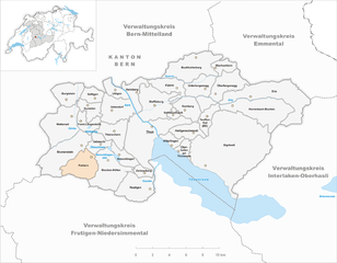
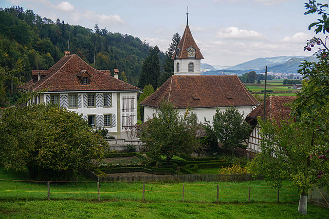
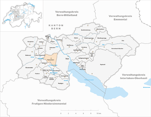
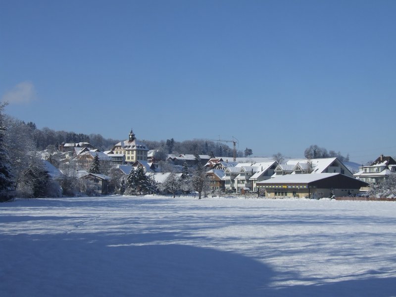
Амзольдинген
Hiking in Амзольдинген
Amsoldingen is a charming village located near Lake Thun in Switzerland, surrounded by beautiful landscapes and picturesque hills. Hiking in this area offers an excellent opportunity to enjoy the natural beauty of the Bernese Oberland region. Here are some highlights and tips for hiking in Amsoldingen:...
- Страна:
- Почтовый код: 3633
- Телефонный код: 033
- Код автомобильного номера: BE
- Координаты: 46° 43' 31" N, 7° 35' 9" E
- GPS треки (wikiloc): [Ссылка]
- Высота над уровнем моря: 644 м m
- Площадь: 4.7 кв.км
- Население: 828
- Веб сайт: [Ссылка]
Эриц
Hiking in Эриц
Eriz, a small village located in the Bernese Oberland region of Switzerland, offers stunning landscapes and a variety of hiking trails suitable for different skill levels. Here’s an overview of what you can expect when hiking in Eriz:...
- Страна:
- Почтовый код: 3619
- Телефонный код: 033
- Код автомобильного номера: BE
- Координаты: 46° 47' 16" N, 7° 48' 42" E
- GPS треки (wikiloc): [Ссылка]
- Высота над уровнем моря: 1015 м m
- Площадь: 21.80 кв.км
- Население: 490
- Веб сайт: [Ссылка]


Цвизельберг
Hiking in Цвизельберг
Zwieselberg, located in Bavaria, Germany, is a beautiful area known for its stunning landscapes, dense forests, and panoramic views of the surrounding mountains. Hiking in this region offers a variety of trails suitable for different skill levels, making it an ideal destination for both novice and experienced hikers....
- Страна:
- Почтовый код: 3645
- Телефонный код: 033
- Код автомобильного номера: BE
- Координаты: 46° 41' 59" N, 7° 36' 59" E
- GPS треки (wikiloc): [Ссылка]
- Высота над уровнем моря: 660 м m
- Площадь: 2.45 кв.км
- Население: 324
- Веб сайт: [Ссылка]
Хаймберг
Hiking in Хаймберг
Heimberg, located in the Canton of Bern in Switzerland, offers beautiful hiking opportunities, characterized by scenic landscapes, picturesque views of the Alps, and charming Swiss countryside. Here are some key features to consider if you're planning a hiking trip in the Heimberg area:...
- Страна:
- Почтовый код: 3627
- Телефонный код: 033
- Код автомобильного номера: BE
- Координаты: 46° 47' 0" N, 7° 36' 0" E
- GPS треки (wikiloc): [Ссылка]
- Высота над уровнем моря: 551 м m
- Площадь: 5.4 кв.км
- Население: 6765
- Веб сайт: [Ссылка]
Ибеши
Hiking in Ибеши
Uebeschi is a picturesque village located in the Bernese Oberland region of Switzerland, known for its stunning landscapes and hiking opportunities. Hiking in this area allows you to enjoy breathtaking views of the Alps, beautiful meadows, and serene forests. Here are some highlights and tips for hiking in Uebeschi:...
- Страна:
- Почтовый код: 3635
- Телефонный код: 033
- Код автомобильного номера: BE
- Координаты: 46° 43' 59" N, 7° 32' 59" E
- GPS треки (wikiloc): [Ссылка]
- Высота над уровнем моря: 685 м m
- Площадь: 4.4 кв.км
- Население: 685
- Веб сайт: [Ссылка]
Оберлангенег
Hiking in Оберлангенег
Oberlangenegg is a beautiful area located in the region of Switzerland, known for its picturesque landscape and excellent hiking opportunities. The region is characterized by its stunning views of the Alps, lush forests, and charming rural surroundings. Here are some highlights of hiking in Oberlangenegg:...
- Страна:
- Почтовый код: 3616
- Телефонный код: 033
- Код автомобильного номера: BE
- Координаты: 46° 46' 59" N, 7° 42' 59" E
- GPS треки (wikiloc): [Ссылка]
- Высота над уровнем моря: 968 м m
- Площадь: 9.15 кв.км
- Население: 475
- Веб сайт: [Ссылка]


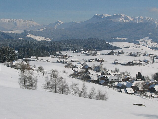
Хайлигеншвенди
Hiking in Хайлигеншвенди
Heiligenschwendi, a picturesque village located in the Swiss canton of Bern, offers a fantastic setting for hiking enthusiasts. Nestled on the slopes of the Swiss Alps and overlooking Lake Thun, it boasts stunning views of the surrounding mountains and lake, making it a perfect destination for both casual walkers and serious hikers....
- Страна:
- Почтовый код: 3625
- Телефонный код: 033
- Код автомобильного номера: BE
- Координаты: 46° 45' 7" N, 7° 40' 56" E
- GPS треки (wikiloc): [Ссылка]
- Высота над уровнем моря: 1114 м m
- Площадь: 6.57 кв.км
- Население: 682
- Веб сайт: [Ссылка]
Фарни
Hiking in Фарни
Fahrni, located in the Canton of Bern, Switzerland, is known for its beautiful landscapes and hiking opportunities. Here’s a guide to hiking in the area:...
- Страна:
- Почтовый код: 3617
- Телефонный код: 033
- Код автомобильного номера: BE
- Координаты: 46° 47' 50" N, 7° 40' 13" E
- GPS треки (wikiloc): [Ссылка]
- Высота над уровнем моря: 850 м m
- Площадь: 6.67 кв.км
- Население: 788
- Веб сайт: [Ссылка]
Ваттенвиль
Hiking in Ваттенвиль
Wattenwil is a charming village located in the Bernese Oberland region of Switzerland, surrounded by beautiful landscapes that are perfect for hiking enthusiasts. The area boasts a variety of trails, catering to different skill levels and interests....
- Страна:
- Почтовый код: 3665
- Телефонный код: 033
- Код автомобильного номера: BE
- Координаты: 46° 45' 34" N, 7° 29' 34" E
- GPS треки (wikiloc): [Ссылка]
- Высота над уровнем моря: 850 м m
- Площадь: 14.54 кв.км
- Население: 2895
- Веб сайт: [Ссылка]

Бухгольтерберг
Hiking in Бухгольтерберг
Buchholterberg is a picturesque region in Switzerland, known for its serene landscapes and well-maintained hiking trails. Here’s what you can expect when hiking in this area:...
- Страна:
- Почтовый код: 3615
- Телефонный код: 033
- Код автомобильного номера: BE
- Координаты: 46° 48' 59" N, 7° 41' 0" E
- GPS треки (wikiloc): [Ссылка]
- Высота над уровнем моря: 1006 м m
- Площадь: 15.34 кв.км
- Население: 1552
- Веб сайт: [Ссылка]
Хорренбах-Бухен
Hiking in Хорренбах-Бухен
Horrenbach-Buchen is a charming area situated in the heart of the Lower Austria region, known for its picturesque landscapes and extensive hiking opportunities. It offers a range of trails that cater to different skill levels, making it an excellent destination for both casual walkers and experienced hikers. Here are some highlights:...
- Страна:
- Почтовый код: 3623
- Телефонный код: 033
- Код автомобильного номера: BE
- Координаты: 46° 45' 59" N, 7° 44' 59" E
- GPS треки (wikiloc): [Ссылка]
- Высота над уровнем моря: 1000 м m
- Площадь: 20.37 кв.км
- Население: 226
- Веб сайт: [Ссылка]
Тойффенталь
Hiking in Тойффенталь
Teuffenthal is a picturesque area that offers fantastic hiking opportunities, especially for those who enjoy beautiful landscapes, nature, and a mix of easy to moderate trails. While specific details about trails in Teuffenthal may vary over time, I can offer you some general tips and considerations for hiking in the area:...
- Страна:
- Почтовый код: 3623
- Телефонный код: 033
- Код автомобильного номера: BE
- Координаты: 46° 45' 57" N, 7° 42' 45" E
- GPS треки (wikiloc): [Ссылка]
- Высота над уровнем моря: 991 м m
- Площадь: 4.5 кв.км
- Население: 165
- Веб сайт: [Ссылка]
Швендибах
Hiking in Швендибах
Schwendibach is a charming area located in Switzerland, known for its stunning natural landscapes and picturesque trails. If you're considering hiking there, you'll be pleased to know that the region offers a variety of hiking routes suitable for different skill levels....
- Страна:
- Почтовый код: 3624
- Телефонный код: 033
- Код автомобильного номера: BE
- Координаты: 46° 45' 59" N, 7° 39' 0" E
- GPS треки (wikiloc): [Ссылка]
- Высота над уровнем моря: 880 м m
- Площадь: 1.5 кв.км
- Население: 249
- Веб сайт: [Ссылка]
Нидерстоккен
Hiking in Нидерстоккен
Niederstocken is a charming village located in the Canton of Bern, Switzerland, and it serves as a great starting point for various hiking trails that showcase the stunning natural beauty of the region. As an instructor, I can help you navigate the area and make the most of your hiking experience. Here are some aspects to consider:...
- Страна:
- Почтовый код: 3632
- Телефонный код: 033
- Код автомобильного номера: BE
- Координаты: 46° 42' 0" N, 7° 35' 0" E
- GPS треки (wikiloc): [Ссылка]
- Высота над уровнем моря: 634 м m
- Площадь: 5.48 кв.км
- Веб сайт: [Ссылка]

Зигрисвиль
Hiking in Зигрисвиль
Sigriswil is a picturesque village located in the Canton of Bern, Switzerland, known for its stunning landscapes and beautiful hiking trails. Nestled near the shores of Lake Thun, Sigriswil offers a variety of hiking options suitable for different fitness levels, making it an attractive destination for outdoor enthusiasts....
- Страна:
- Почтовый код: 3655
- Телефонный код: 033
- Код автомобильного номера: BE
- Координаты: 46° 44' 7" N, 7° 44' 52" E
- GPS треки (wikiloc): [Ссылка]
- Высота над уровнем моря: 1349 м m
- Площадь: 55.34 кв.км
- Население: 4788
- Веб сайт: [Ссылка]
Ваксельдорн
Hiking in Ваксельдорн
Wachseldorn, often referred to by its breathtaking natural scenery, offers a variety of hiking trails suitable for different skill levels. While I don’t have real-time updates, I can provide you with general information based on existing hiking knowledge....
- Страна:
- Почтовый код: 3618
- Телефонный код: 033
- Код автомобильного номера: BE
- Координаты: 46° 49' 12" N, 7° 44' 14" E
- GPS треки (wikiloc): [Ссылка]
- Высота над уровнем моря: 985 м m
- Площадь: 3.52 кв.км
- Население: 234
- Веб сайт: [Ссылка]

Полерн
Hiking in Полерн
Pohlern is a charming village located in the region of Switzerland, near the picturesque Lake Thun and the majestic Alps. It's a great destination for hiking enthusiasts, offering a variety of trails suitable for different skill levels....
- Страна:
- Почтовый код: 3638
- Телефонный код: 033
- Код автомобильного номера: BE
- Координаты: 46° 43' 0" N, 7° 31' 59" E
- GPS треки (wikiloc): [Ссылка]
- Высота над уровнем моря: 710 м m
- Площадь: 9.89 кв.км
- Население: 257
- Веб сайт: [Ссылка]
Тирахерн
Hiking in Тирахерн
Thierachern is a picturesque village located in the Swiss canton of Bern, surrounded by beautiful landscapes that make it a great destination for hiking enthusiasts. The area offers a variety of trails suitable for all levels, from easy walks to more challenging hikes....
- Страна:
- Почтовый код: 3634
- Телефонный код: 033
- Код автомобильного номера: BE
- Координаты: 46° 45' 0" N, 7° 34' 0" E
- GPS треки (wikiloc): [Ссылка]
- Высота над уровнем моря: 610 м m
- Площадь: 7.5 кв.км
- Население: 2401
- Веб сайт: [Ссылка]


Хильтерфинген
Hiking in Хильтерфинген
Hilterfingen, located in Switzerland near Lake Thun, offers a variety of hiking opportunities that showcase the stunning natural beauty of the region. The area is known for its picturesque landscapes, including the lake, mountains, and charming villages....
- Страна:
- Почтовый код: 3626, 3652
- Телефонный код: 033
- Код автомобильного номера: BE
- Координаты: 46° 44' 36" N, 7° 39' 30" E
- GPS треки (wikiloc): [Ссылка]
- Высота над уровнем моря: 686 м m
- Площадь: 2.8 кв.км
- Население: 4072
- Веб сайт: [Ссылка]
Итендорф
Hiking in Итендорф
Uetendorf is a charming village located in the Canton of Bern, Switzerland. It’s surrounded by beautiful landscapes, making it a great spot for hiking enthusiasts. Here are some key points to consider if you're planning to hike in and around Uetendorf:...
- Страна:
- Почтовый код: 3661
- Телефонный код: 033
- Код автомобильного номера: BE
- Координаты: 46° 45' 59" N, 7° 34' 0" E
- GPS треки (wikiloc): [Ссылка]
- Высота над уровнем моря: 554 м m
- Площадь: 10.15 кв.км
- Население: 5950
- Веб сайт: [Ссылка]

Уттиген
Hiking in Уттиген
Uttigen, a small municipality in the canton of Bern, Switzerland, is surrounded by beautiful landscapes and offers various hiking opportunities. The area is characterized by scenic views, rolling hills, and proximity to both urban and natural attractions....
- Страна:
- Почтовый код: 3628
- Телефонный код: 033
- Код автомобильного номера: BE
- Координаты: 46° 47' 38" N, 7° 34' 35" E
- GPS треки (wikiloc): [Ссылка]
- Высота над уровнем моря: 543 м m
- Площадь: 3.05 кв.км
- Население: 2070
- Веб сайт: [Ссылка]


Оберштоккен
Hiking in Оберштоккен
Oberstocken, located in Switzerland, offers stunning scenery and a variety of hiking opportunities for outdoor enthusiasts. With its mountainous terrain, lush valleys, and picturesque views, it appeals to hikers of all skill levels....
- Страна:
- Почтовый код: 3632
- Телефонный код: 033
- Код автомобильного номера: BE
- Координаты: 46° 41' 59" N, 7° 32' 59" E
- GPS треки (wikiloc): [Ссылка]
- Высота над уровнем моря: 691 м m
- Площадь: 4.12 кв.км
- Веб сайт: [Ссылка]

Хёфен-Тун
Hiking in Хёфен-Тун
Höfen is a picturesque district located near Thun, Switzerland, nestled between the beautiful landscapes of the Bernese Oberland. This area offers a variety of hiking opportunities suitable for different skill levels, combined with stunning views of Lake Thun and the surrounding mountains....
- Страна:
- Почтовый код: 3631
- Телефонный код: 033
- Код автомобильного номера: BE
- Координаты: 46° 42' 59" N, 7° 33' 0" E
- GPS треки (wikiloc): [Ссылка]
- Высота над уровнем моря: 705 м m
- Площадь: 4.62 кв.км
- Веб сайт: [Ссылка]


Блуменштайн
Hiking in Блуменштайн
Blumenstein is a picturesque area that offers a variety of hiking opportunities, perfect for nature lovers and outdoor enthusiasts. Located in Switzerland, it’s known for its stunning landscapes, rich biodiversity, and peaceful environment. Here are some key highlights and tips for hiking in Blumenstein:...
- Страна:
- Почтовый код: 3638
- Телефонный код: 033
- Код автомобильного номера: BE
- Координаты: 46° 43' 59" N, 7° 30' 59" E
- GPS треки (wikiloc): [Ссылка]
- Высота над уровнем моря: 659 м m
- Площадь: 15.52 кв.км
- Население: 1227
- Веб сайт: [Ссылка]


Бургиштайн
Hiking in Бургиштайн
Burgistein, a quaint village in Switzerland located in the Bernese Oberland region, offers numerous hiking opportunities that cater to different skill levels. Here are some key points about hiking in Burgistein:...
- Страна:
- Почтовый код: 3664
- Телефонный код: 033
- Код автомобильного номера: BE
- Координаты: 46° 47' 31" N, 7° 30' 12" E
- GPS треки (wikiloc): [Ссылка]
- Высота над уровнем моря: 746 м m
- Площадь: 7.53 кв.км
- Население: 1092
- Веб сайт: [Ссылка]
Кинерсрюти
Hiking in Кинерсрюти
Kienersrüti is a picturesque area located in the Swiss Alps, known for its stunning landscapes and well-marked hiking trails. Here are some key points to consider when planning a hiking trip in Kienersrüti:...
- Страна:
- Почтовый код: 3628
- Телефонный код: 033
- Код автомобильного номера: BE
- Координаты: 46° 47' 50" N, 7° 33' 39" E
- GPS треки (wikiloc): [Ссылка]
- Высота над уровнем моря: 579 м m
- Площадь: 0.8 кв.км

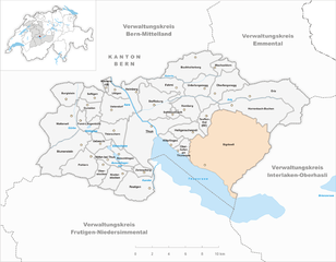
Оберхофен-ам-Тунерзее
Hiking in Оберхофен-ам-Тунерзее
Oberhofen am Thunersee is a beautiful area located by Lake Thun in the Bernese Oberland region of Switzerland. It's an excellent hiking destination, featuring picturesque landscapes, stunning views of the lake, and access to the surrounding mountains....
- Страна:
- Почтовый код: 3653
- Телефонный код: 033
- Код автомобильного номера: BE
- Координаты: 46° 43' 47" N, 7° 40' 9" E
- GPS треки (wikiloc): [Ссылка]
- Высота над уровнем моря: 563 м m
- Площадь: 2.8 кв.км
- Население: 2415
- Веб сайт: [Ссылка]


Гурцелен
Hiking in Гурцелен
Gurzelen, located in Switzerland, offers beautiful hiking opportunities for nature enthusiasts. The area is characterized by stunning landscapes, including rolling hills, forests, and views of surrounding mountains. Here are some key highlights and tips for hiking in Gurzelen:...
- Страна:
- Почтовый код: 3663
- Телефонный код: 033
- Код автомобильного номера: BE
- Координаты: 46° 46' 32" N, 7° 32' 9" E
- GPS треки (wikiloc): [Ссылка]
- Высота над уровнем моря: 621 м m
- Площадь: 4.5 кв.км
- Население: 829
- Веб сайт: [Ссылка]

Ройтиген
Hiking in Ройтиген
Reutigen, located in the picturesque region of Switzerland, offers wonderful hiking opportunities for both beginner and experienced hikers. Nestled near Bern, this charming village provides access to beautiful landscapes, lush forests, and breathtaking views of the Alps....
- Страна:
- Почтовый код: 3647
- Телефонный код: 033
- Код автомобильного номера: BE
- Координаты: 46° 41' 34" N, 7° 36' 19" E
- GPS треки (wikiloc): [Ссылка]
- Высота над уровнем моря: 754 м m
- Площадь: 11.26 кв.км
- Население: 983
- Веб сайт: [Ссылка]


Форст-Ленгенбюль
Hiking in Форст-Ленгенбюль
Forst-Längenbühl is a picturesque area located in Switzerland, known for its stunning landscapes, diverse trails, and natural beauty. Here’s what you can expect when hiking in Forst-Längenbühl:...
- Страна:
- Почтовый код: 3636
- Телефонный код: 032
- Код автомобильного номера: BE
- Координаты: 46° 45' 0" N, 7° 30' 59" E
- GPS треки (wikiloc): [Ссылка]
- Высота над уровнем моря: 652 м m
- Площадь: 4.5 кв.км
- Население: 778
- Веб сайт: [Ссылка]
Унтерлангенег
Hiking in Унтерлангенег
Unterlangenegg is a charming village situated in the Bernese Oberland region of Switzerland, known for its picturesque landscapes, rolling hills, and proximity to the stunning Alps. Hiking in this area offers a variety of trails suitable for different skill levels, making it a great destination for both beginners and experienced hikers....
- Страна:
- Почтовый код: 3614
- Телефонный код: 033
- Код автомобильного номера: BE
- Координаты: 46° 46' 59" N, 7° 42' 59" E
- GPS треки (wikiloc): [Ссылка]
- Высота над уровнем моря: 831 м m
- Площадь: 6.81 кв.км
- Население: 987
- Веб сайт: [Ссылка]


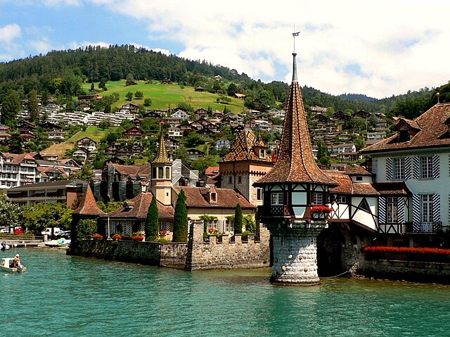
Тун
- город в Швейцарии
Hiking in Тун
Thun, located in the Bernese Oberland of Switzerland, is a fantastic destination for hiking enthusiasts, offering breathtaking views of the surrounding mountains and Lake Thun. Here are some highlights and tips for hiking in this beautiful area:...
- Страна:
- Почтовый код: 3600
- Телефонный код: 033
- Код автомобильного номера: BE
- Координаты: 46° 45' 32" N, 7° 37' 48" E
- GPS треки (wikiloc): [Ссылка]
- Высота над уровнем моря: 560 м m
- Площадь: 21.60 кв.км
- Население: 43743
- Веб сайт: [Ссылка]
Хомберг
- община в Швейцарии, Берн
Hiking in Хомберг
Homberg, located in the Bern region of Switzerland, offers a variety of beautiful hiking options. The area is characterized by its picturesque landscapes, rolling hills, and stunning views of the surrounding Alps. Here are some key points to consider if you're planning a hike in Homberg:...
- Страна:
- Почтовый код: 3622
- Телефонный код: 033
- Код автомобильного номера: BE
- Координаты: 46° 45' 59" N, 7° 40' 0" E
- GPS треки (wikiloc): [Ссылка]
- Высота над уровнем моря: 941 м m
- Площадь: 6.52 кв.км
- Население: 523
- Веб сайт: [Ссылка]
Зефтиген
Hiking in Зефтиген
Seftigen is a charming municipality located in the canton of Bern, Switzerland, nestled in the foothills of the Bernese Alps. Hiking in this area offers stunning views of the mountains, picturesque landscapes, and a chance to explore the local flora and fauna. Here are some highlights and tips for hiking in Seftigen:...
- Страна:
- Почтовый код: 3662
- Телефонный код: 033
- Код автомобильного номера: BE
- Координаты: 46° 47' 25" N, 7° 32' 21" E
- GPS треки (wikiloc): [Ссылка]
- Высота над уровнем моря: 591 м m
- Площадь: 7.5 кв.км
- Население: 2191
- Веб сайт: [Ссылка]

Штеффисбург
Hiking in Штеффисбург
Steffisburg is a charming village located in the Canton of Thun in Switzerland, offering access to stunning natural scenery and a variety of hiking opportunities. Here’s a brief overview of what you can expect when hiking in and around Steffisburg:...
- Страна:
- Почтовый код: 3612
- Телефонный код: 033
- Код автомобильного номера: BE
- Координаты: 46° 46' 53" N, 7° 37' 58" E
- GPS треки (wikiloc): [Ссылка]
- Высота над уровнем моря: 607 м m
- Площадь: 13.5 кв.км
- Население: 15816
- Веб сайт: [Ссылка]