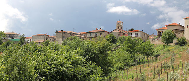
Торре-Бормида (Torre Bormida, Torre Bormida)
- коммуна Италии
 Hiking in Торре-Бормида
Torre Bormida, located in the region of Piedmont, Italy, is a lesser-known destination that offers stunning landscapes and a range of hiking opportunities. The area is characterized by its rugged terrain, picturesque views, and a mix of natural beauty and historical sites.
Hiking Trails and Routes
-
Local Trails: There are various trails around Torre Bormida that cater to different skill levels. Beginners can enjoy easier walks through the valleys, while experienced hikers can tackle more challenging routes that involve elevation changes.
-
Nature Reserves: The region is close to several natural parks and reserves, where you can find well-marked trails. These areas often feature diverse flora and fauna, making hikes both scenic and educational.
-
Cultural Hikes: Some trails can lead you to historical landmarks or small villages, allowing you to experience the local culture, architecture, and cuisine along the way.
Recommendations
- Best Time to Hike: The optimal hiking seasons are spring and fall when the weather is mild and the landscapes are at their most beautiful.
- Safety Tips: Always carry adequate supplies, including water, food, a first-aid kit, and a detailed map or GPS device. Check weather forecasts and trail conditions before setting out.
- Local Guidance: Consider hiring a local guide or joining a hiking group, especially if you're unfamiliar with the area. They can enhance your experience by providing insights into the local ecology and history.
Preparing for Your Hike
- Clothing: Wear layers, as temperatures can change quickly in the mountains. Good hiking boots are a must.
- Hydration and Snacks: Bring enough water and high-energy snacks to keep you fueled throughout your hike.
- Waste Management: Respect nature by packing out any trash and following the principles of Leave No Trace.
Conclusion
Hiking near Torre Bormida offers a unique opportunity to explore Italy's natural beauty away from the typical tourist paths. Whether you're looking for a leisurely walk or an adventurous trek, you'll find a variety of trails to suit your interests and skill level. Enjoy the journey!
- Страна:

- Почтовый код: 12070
- Телефонный код: 0173
- Код автомобильного номера: CN
- Координаты: 44° 34' 0" N, 8° 9' 0" E


- GPS треки (wikiloc): [Ссылка]
- Высота над уровнем моря: 391 м m
- Площадь: 7.18 кв.км
- Население: 179
- Веб сайт: http://comune.torrebormida.cn.it/
- Википедия русская: wiki(ru)
- Википедия английская: wiki(en)
- Википедия национальная: wiki(it)
- Хранилище Wikidata: Wikidata: Q20507
- Катеория в википедии: [Ссылка]
- код Freebase: [/m/0gbdt2]
- код GeoNames: Альт: [6542839]
- ID отношения в OpenStreetMap: [43299]
- UN/LOCODE: [ITOOI]
- код ISTAT: 004226
- кадастровый код Италии: L252
Граничит с регионами:
Берголо
- коммуна Италии
Hiking in Берголо
Bergolo, a small village located in the Piedmont region of Italy, is well-known for its picturesque landscapes and historical charm. Hiking in and around Bergolo offers a unique blend of natural beauty, cultural heritage, and tranquility, making it an excellent choice for outdoor enthusiasts....
- Страна:
- Почтовый код: 12074
- Телефонный код: 0173
- Код автомобильного номера: CN
- Координаты: 44° 32' 0" N, 8° 11' 0" E
- GPS треки (wikiloc): [Ссылка]
- Высота над уровнем моря: 616 м m
- Площадь: 3.11 кв.км
- Население: 66
- Веб сайт: [Ссылка]

Бозия
- коммуна Италии
Hiking in Бозия
Bosio, a quaint town nestled in the Piedmont region of northern Italy, offers several hiking opportunities that allow you to explore its beautiful landscapes, rich history, and unique cultural heritage. The surrounding areas, characterized by rolling hills, lush forests, and stunning views of the Apennine Mountains, make it a fantastic destination for outdoor enthusiasts....
- Страна:
- Почтовый код: 12050
- Телефонный код: 0173
- Код автомобильного номера: CN
- Координаты: 44° 36' 0" N, 8° 9' 0" E
- GPS треки (wikiloc): [Ссылка]
- Высота над уровнем моря: 484 м m
- Площадь: 5.54 кв.км
- Население: 180
- Веб сайт: [Ссылка]

Кортемилия
- коммуна Италии
Hiking in Кортемилия
Cortemilia, located in the Piedmont region of northwestern Italy, is known for its stunning landscapes, rich history, and delightful food. Hiking in this area offers routes that take you through vineyards, forests, and scenic views of the surrounding hills....
- Страна:
- Почтовый код: 12074
- Телефонный код: 0173
- Код автомобильного номера: CN
- Координаты: 44° 34' 30" N, 8° 11' 30" E
- GPS треки (wikiloc): [Ссылка]
- Высота над уровнем моря: 247 м m
- Площадь: 24.99 кв.км
- Население: 2275
- Веб сайт: [Ссылка]

Краванцана
- коммуна Италии
Hiking in Краванцана
Cravanzana, a charming village located in the Piedmont region of Italy, is nestled in the rolling hills of the Langhe area, known for its stunning landscapes, vineyards, and rich cultural heritage. Hiking in and around Cravanzana offers a variety of scenic trails that showcase the natural beauty of this region....
- Страна:
- Почтовый код: 12050
- Телефонный код: 0173
- Код автомобильного номера: CN
- Координаты: 44° 35' 0" N, 8° 8' 0" E
- GPS треки (wikiloc): [Ссылка]
- Высота над уровнем моря: 585 м m
- Площадь: 8.12 кв.км
- Население: 384
- Веб сайт: [Ссылка]

Фейзольо
- коммуна Италии
Hiking in Фейзольо
Feisoglio is a small village located in the Piedmont region of Italy, nestled in the beautiful landscape of the Langhe area. This region offers spectacular views, rolling hills, vineyards, and a rich cultural heritage, making it a delightful destination for hiking enthusiasts....
- Страна:
- Почтовый код: 12050
- Телефонный код: 0173
- Код автомобильного номера: CN
- Координаты: 44° 33' 0" N, 8° 6' 0" E
- GPS треки (wikiloc): [Ссылка]
- Высота над уровнем моря: 706 м m
- Площадь: 7.67 кв.км
- Население: 303
- Веб сайт: [Ссылка]

Левиче
- коммуна Италии
Hiking in Левиче
Levice is a town located in northern Italy, and while it may not be as widely recognized as some of the more famous hiking destinations in the Piedmont region, it offers some beautiful landscapes and opportunities for outdoor activities....
- Страна:
- Почтовый код: 12070
- Телефонный код: 0173
- Код автомобильного номера: CN
- Координаты: 44° 32' 0" N, 8° 9' 0" E
- GPS треки (wikiloc): [Ссылка]
- Высота над уровнем моря: 547 м m
- Площадь: 15.74 кв.км
- Население: 214
- Веб сайт: [Ссылка]