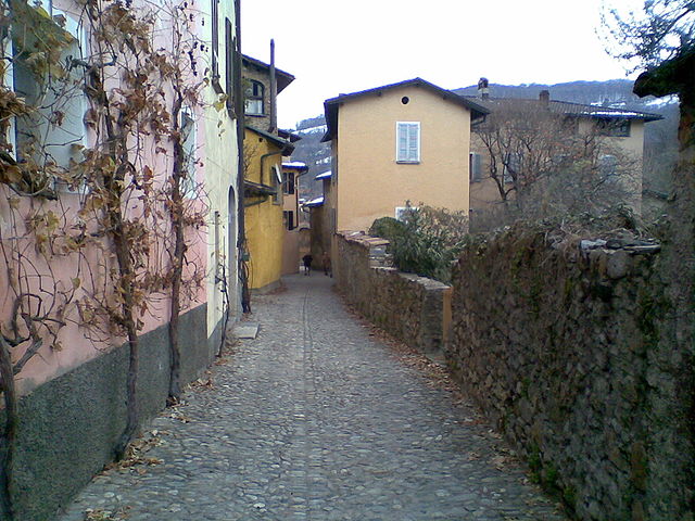
Torricella-Taverne (Torricella-Taverne)

 Hiking in Torricella-Taverne
Torricella-Taverne is a picturesque region located in the Canton of Ticino, Switzerland. It offers a variety of hiking opportunities, characterized by stunning landscapes, lush greenery, and diverse ecosystems. Here are some highlights and tips for hiking in this area:
Trails and Terrain
- Variety of Trails: Torricella-Taverne offers trails that cater to different skill levels, from easy walks suitable for families to more challenging hikes for experienced trekkers.
- Scenic Routes: Many trails boast breathtaking views of the surrounding mountains, valleys, and the nearby Lake Lugano. The trails often pass through charming villages and natural reserves.
- Nature Experiences: The area is rich in biodiversity, and hikers may encounter various flora and fauna, particularly in the spring and summer months.
Popular Hikes
- Path of the Casserine: A quite popular walking route that offers marvelous views and is set amidst beautiful natural surroundings.
- Hikes to Monte Brè: This can include a combination of hiking and potentially taking the funicular for part of the climb, offering stunning panoramic views of the Lugano area.
- Circular Trails: There are circular routes available that allow hikers to explore both the mountains and valleys without the need for retracing steps.
Tips for Hiking
- Weather: Check the weather forecast before heading out, as conditions can change rapidly in mountainous areas.
- Gear: Wear appropriate hiking shoes and clothing for varying trail conditions. Carry essential gear such as water, snacks, first aid kits, and navigation tools.
- Stay on Marked Trails: To preserve nature and maintain safety, stick to the marked trails.
- Permits & Regulations: While most trails don’t require permits, it's always good to check local regulations, especially in natural reserve areas.
- Respect Wildlife: Be mindful of local wildlife and keep a safe distance; do not feed animals you may encounter along the trails.
Accessibility
- Public Transport: Torricella-Taverne is accessible via public transport from major cities, making it a convenient location for day hikes.
- Local Guides: Consider hiring local hiking guides for a better understanding of the area's ecology and history.
Conclusion
Hiking in Torricella-Taverne can be a rewarding experience, offering stunning views and a chance to connect with nature. Whether you're an experienced hiker or just looking for a leisurely walk, this area caters to all levels of outdoor enthusiasts. Enjoy your hike!
- Страна:

- Почтовый код: 6807, 6808
- Телефонный код: 091
- Код автомобильного номера: TI
- Координаты: 46° 4' 0" N, 8° 55' 0" E


- GPS треки (wikiloc): [Ссылка]
- Высота над уровнем моря: 427 м m
- Площадь: 5.23 кв.км
- Население: 3053
- Веб сайт: http://www.torricella-taverne.ch
- Википедия английская: wiki(en)
- Википедия национальная: wiki(de)
- Хранилище Wikidata: Wikidata: Q68001
- Катеория в википедии: [Ссылка]
- код Freebase: [/m/0gztkp]
- код GeoNames: Альт: [7287320]
- код VIAF: Альт: [235287937]
- ID отношения в OpenStreetMap: [1684764]
- код GND: Альт: [7698438-2]
- идентификатор местоположения ArchINFORM: [42221]
- идентификатор HDS: [2212]
- код швейцарского муниципалитета: [5227]
Граничит с регионами:


Alto Malcantone
Hiking in Alto Malcantone
Alto Malcantone is a beautiful region in the Canton of Ticino, Switzerland, known for its stunning landscapes, serene forests, and picturesque villages. The area offers a variety of hiking trails suitable for different skill levels, making it a great destination for both novice and experienced hikers. Here are some key points to consider if you’re planning a hike in Alto Malcantone:...
- Страна:
- Почтовый код: 6939
- Телефонный код: 91
- Код автомобильного номера: TI
- Координаты: 46° 2' 0" N, 8° 53' 0" E
- GPS треки (wikiloc): [Ссылка]
- Высота над уровнем моря: 810 м m
- Площадь: 22.1 кв.км
- Население: 1405
- Веб сайт: [Ссылка]


Bedano
Hiking in Bedano
Bedano is a charming municipality located in the Ticino district of Switzerland, known for its beautiful landscapes and outdoor activities, including hiking. While it may not be as renowned as some larger Swiss hiking destinations, it offers a variety of trails that showcase its natural beauty and scenic views....
- Страна:
- Почтовый код: 6930
- Телефонный код: 091
- Код автомобильного номера: TI
- Координаты: 46° 3' 0" N, 8° 55' 0" E
- GPS треки (wikiloc): [Ссылка]
- Высота над уровнем моря: 387 м m
- Площадь: 1.91 кв.км
- Население: 1542
- Веб сайт: [Ссылка]


Lamone
Hiking in Lamone
Lamone is a picturesque area located in the Canton of Ticino, Switzerland, known for its stunning landscapes, rich cultural heritage, and numerous outdoor activities, including hiking. Here are some key points regarding hiking in Lamone:...
- Страна:
- Почтовый код: 6814
- Телефонный код: 091
- Код автомобильного номера: TI
- Координаты: 46° 2' 43" N, 8° 55' 54" E
- GPS треки (wikiloc): [Ссылка]
- Высота над уровнем моря: 326 м m
- Площадь: 1.8 кв.км
- Население: 1780
- Веб сайт: [Ссылка]

Origlio
Hiking in Origlio
Origlio is a picturesque area located in the Canton of Ticino in Switzerland, known for its beautiful landscapes and outdoor activities, including hiking. Here are some key points about hiking in Origlio:...
- Страна:
- Почтовый код: 6945
- Телефонный код: 091
- Код автомобильного номера: TI
- Координаты: 46° 3' 0" N, 8° 57' 0" E
- GPS треки (wikiloc): [Ссылка]
- Высота над уровнем моря: 452 м m
- Площадь: 2.1 кв.км
- Население: 1471
- Веб сайт: [Ссылка]