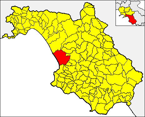
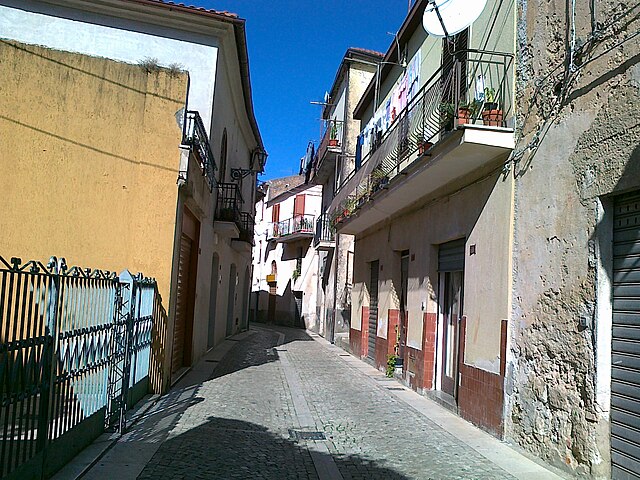
Трентинара (Trentinara, Trentinara)

- коммуна Италии
 Hiking in Трентинара
Trentinara, a charming village in the Campania region of Italy, is known for its stunning landscapes and excellent hiking opportunities. Nestled in the Cilento and Vallo di Diano National Park, which is a UNESCO World Heritage site, Trentinara offers a variety of trails that cater to different skill levels, making it a great destination for both novice hikers and experienced trekkers.
Hiking Trails
-
Sentiero degli Dei (Path of the Gods): This is one of the most famous hiking trails in the region. It runs from Bomerano to Nocelle and offers breathtaking views of the Amalfi Coast. While the start isn’t directly in Trentinara, it can be an excellent day trip to explore this iconic route.
-
Cilento National Park Trails: There are numerous paths within the park that can be accessed from Trentinara. These trails allow hikers to explore the diverse flora and fauna, ancient ruins, and stunning vistas.
-
Mount Gelbison: For those seeking a more challenging hike, the ascent to Mount Gelbison is a rewarding option. The trail leads you through lush forests and offers panoramic views from the summit.
-
Local Circular Trails: The area around Trentinara features several circular routes that allow you to experience the local countryside, olive groves, and vineyards. These trails are typically less traveled, providing a peaceful hiking experience.
What to Expect
-
Scenery: Expect to encounter dramatic cliffs, rolling hills, and expansive views of the Mediterranean Sea. The region's natural beauty is enhanced by the quaint charm of rural Italian villages.
-
Wildlife: The national park is home to various species of wildlife, including deer, wild boar, and numerous bird species. Keep your eyes peeled for the unique flora and fauna along the trails.
-
Cultural Sites: Along the trails, you may come across historic sites, including ancient churches and ruins, which add a cultural dimension to your hiking experience.
Tips for Hiking in Trentinara
-
Check Trail Conditions: Before you set out, check local trail conditions and seek advice from local tourism offices if needed.
-
Stay Hydrated: Carry plenty of water, especially during the summer months, as some trails can be quite exposed to the sun.
-
Wear Proper Footwear: Sturdy hiking boots are recommended to navigate rocky and uneven terrain comfortably.
-
Local Guides: Consider hiring a local guide if you want to learn more about the area’s history and ecology while enjoying your hike.
-
Respect Nature: Always follow Leave No Trace principles to preserve the natural beauty of the park.
Conclusion
Hiking in Trentinara offers a wonderful mix of natural beauty, cultural exploration, and outdoor activity. Whether you’re looking for a leisurely walk or an adventurous trek, the region is sure to provide a memorable experience. Enjoy your hike and take time to soak in the breathtaking views!
- Страна:

- Почтовый код: 84070
- Телефонный код: 0828
- Код автомобильного номера: SA
- Координаты: 40° 24' 0" N, 15° 7' 0" E


- GPS треки (wikiloc): [Ссылка]
- Высота над уровнем моря: 606 м m
- Площадь: 23.44 кв.км
- Население: 1625
- Веб сайт: http://www.comune.trentinara.sa.it
- Википедия русская: wiki(ru)
- Википедия английская: wiki(en)
- Википедия национальная: wiki(it)
- Хранилище Wikidata: Wikidata: Q81776
- Катеория в википедии: [Ссылка]
- код Freebase: [/m/0frh7k]
- код GeoNames: Альт: [6541196]
- ID отношения в OpenStreetMap: [40474]
- код ISTAT: 065152
- кадастровый код Италии: L377
Граничит с регионами:

Капаччо-Пестум
- коммуна Италии
Hiking in Капаччо-Пестум
Capaccio Paestum, located in the Campania region of Italy, is an excellent destination for hiking, offering a rich combination of historical sites, natural beauty, and diverse landscapes. Here are some highlights and tips for hiking in this area:...
- Страна:
- Почтовый код: 84047
- Телефонный код: 0828
- Код автомобильного номера: SA
- Координаты: 40° 25' 0" N, 15° 5' 0" E
- GPS треки (wikiloc): [Ссылка]
- Высота над уровнем моря: 0 м m
- Площадь: 113 кв.км
- Население: 22802
- Веб сайт: [Ссылка]

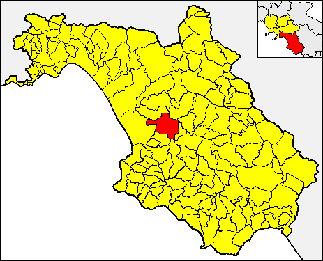
Чичерале
- коммуна Италии
Hiking in Чичерале
Cicerale is a charming town located in the Campania region of Italy, known for its scenic landscapes and natural beauty. It offers a variety of hiking trails suitable for different skill levels, making it a great destination for both novice and experienced hikers....
- Страна:
- Почтовый код: 84053
- Телефонный код: 0974
- Код автомобильного номера: SA
- Координаты: 40° 21' 0" N, 15° 8' 0" E
- GPS треки (wikiloc): [Ссылка]
- Высота над уровнем моря: 475 м m
- Площадь: 41.37 кв.км
- Население: 1194
- Веб сайт: [Ссылка]

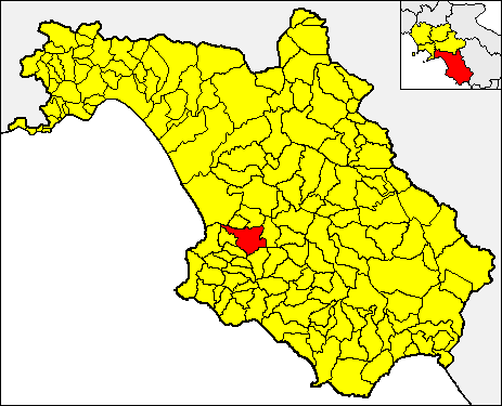
Джунгано
- коммуна Италии
Hiking in Джунгано
Giungano is a charming village located in the Campania region of Italy, nestled within the Cilento National Park—a UNESCO World Heritage Site known for its stunning landscapes, coastal views, and rich biodiversity. Hiking in Giungano offers a unique blend of natural beauty, cultural heritage, and outdoor adventure. Here are some highlights and tips for hiking in this area:...
- Страна:
- Почтовый код: 84050
- Телефонный код: 0828
- Код автомобильного номера: SA
- Координаты: 40° 24' 0" N, 15° 7' 0" E
- GPS треки (wikiloc): [Ссылка]
- Высота над уровнем моря: 250 м m
- Площадь: 11.7 кв.км
- Население: 1321
- Веб сайт: [Ссылка]


Монтефорте-Чиленто
- коммуна Италии
Hiking in Монтефорте-Чиленто
Monteforte Cilento is a beautiful small village located in the Cilento and Vallo di Diano National Park in southern Italy. This area is renowned for its stunning landscapes, rich biodiversity, and historical significance, making it an excellent destination for hiking enthusiasts....
- Страна:
- Почтовый код: 84060
- Телефонный код: 0974
- Код автомобильного номера: SA
- Координаты: 40° 22' 0" N, 15° 12' 0" E
- GPS треки (wikiloc): [Ссылка]
- Высота над уровнем моря: 600 м m
- Площадь: 22.17 кв.км
- Население: 545
- Веб сайт: [Ссылка]

Роккадаспиде
- коммуна Италии
Hiking in Роккадаспиде
Roccadaspide, located in the province of Salerno in the Campania region of Italy, offers a rich hiking experience with its picturesque landscapes, rolling hills, and diverse flora and fauna. Here are some key aspects to consider when planning a hiking trip in Roccadaspide:...
- Страна:
- Почтовый код: 84069
- Телефонный код: 0828
- Код автомобильного номера: SA
- Координаты: 40° 26' 0" N, 15° 12' 0" E
- GPS треки (wikiloc): [Ссылка]
- Высота над уровнем моря: 340 м m
- Площадь: 64.16 кв.км
- Население: 7116
- Веб сайт: [Ссылка]