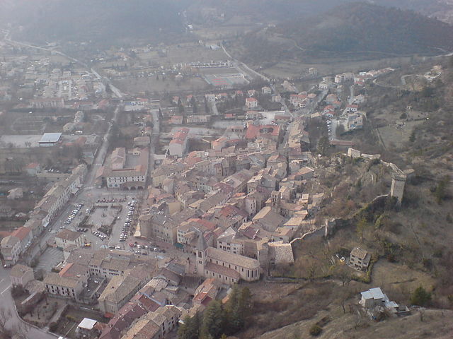
Триганс (Trigance, Trigance)

- коммуна во Франции
 Hiking in Триганс
Trigance is a charming village located in the Provence-Alpes-Côte d'Azur region of France, specifically in the Var department. It's nestled within the beautiful scenery of the Verdon Regional Natural Park, which is renowned for its breathtaking landscapes, stunning gorges, and rich biodiversity. Hiking in and around Trigance provides a fantastic opportunity to explore the natural beauty and the cultural heritage of the area.
Hiking Trails and Routes
-
Sentier de Trigance: This trail offers a pleasant walk starting from the village and taking you through picturesque countryside, with opportunities to enjoy views of the surrounding hills and valleys. It's relatively easy and great for families.
-
Les Gorges du Verdon: A short drive from Trigance, the Verdon Gorge is one of the most famous hiking areas in the region. There are various trails, including the well-known Sentier Blanc-Martel, which is more challenging and rewards hikers with stunning views of the gorge.
-
Sentier des Pêcheurs: This is a beautiful, relatively easy trail following the banks of the Verdon River. It's particularly scenic and offers plenty of opportunities for photography, picnicking, and observing local flora and fauna.
-
Col de la Croix: For those looking for more elevation and challenge, trails leading to higher altitudes will offer panoramic views of the landscape and might even take you to hidden natural gems like waterfalls and scenic overlooks.
Hiking Tips
- Terrain: The terrains can vary significantly, from easy paths to steep and rugged trails, so choose a hike that matches your fitness level and experience.
- Weather: The weather can change rapidly in the region, especially in higher elevations. Always check the weather forecast and dress in layers.
- Hydration and Food: Carry enough water and snacks since some trails can be long and may not have facilities nearby.
- Wildlife: Be cautious of wildlife and respect the natural environment. Stay on marked paths to minimize your impact.
- Local Regulations: Be aware of any local regulations regarding hiking, as certain areas may have restrictions to protect wildlife or the environment.
Practical Information
- Access: Trigance is accessible by car, and there are signs for hiking trails throughout the area. You can also find local guides or maps in the village for more intricate route planning.
- Accommodation: Consider staying at local guesthouses or campsites to fully immerse yourself in the area and have easy access to trails.
In conclusion, Trigance is a fantastic base for hiking enthusiasts looking to explore the rugged beauty of the Verdon region, with trails suitable for all levels of experience. Enjoy your hiking adventure!
- Страна:

- Почтовый код: 83840
- Координаты: 43° 45' 40" N, 6° 26' 38" E


- GPS треки (wikiloc): [Ссылка]
- Площадь: 60.6 кв.км
- Население: 173
- Википедия русская: wiki(ru)
- Википедия английская: wiki(en)
- Википедия национальная: wiki(fr)
- Хранилище Wikidata: Wikidata: Q592029
- Катеория в википедии: [Ссылка]
- код Freebase: [/m/03x_wzx]
- код GeoNames: Альт: [2971682]
- номер SIREN: [218301422]
- код BNF: [15277969s]
- код тезауруса PACTOLS: [pcrtP6YcWA8Yl4]
- код муниципалитета INSEE: 83142
Граничит с регионами:

Ругон
- коммуна во Франции
Hiking in Ругон
Rougon is a picturesque village located in the Alpes-de-Haute-Provence region of France, particularly notable for its stunning scenery and proximity to the Verdon Gorge (Gorges du Verdon), which is one of Europe's most beautiful canyons. The area is a great destination for hiking enthusiasts, offering a range of trails suitable for various experience levels....
- Страна:
- Почтовый код: 04120
- Координаты: 43° 47' 54" N, 6° 24' 7" E
- GPS треки (wikiloc): [Ссылка]
- Площадь: 35.83 кв.км
- Население: 104


Ле-Бурге
- коммуна во Франции
Hiking in Ле-Бурге
Le Bourguet is a picturesque area located in the Provence region of France, known for its stunning natural landscapes, quaint villages, and rich history. Hiking in Le Bourguet can be a rewarding experience as it offers a variety of trails that cater to different skill levels, from easy walks to more challenging hikes....
- Страна:
- Почтовый код: 83840
- Координаты: 43° 47' 3" N, 6° 31' 7" E
- GPS треки (wikiloc): [Ссылка]
- Площадь: 25.39 кв.км
- Население: 30
Кастеллан
- коммуна во Франции
Hiking in Кастеллан
Castellane is a picturesque village located in the Provence-Alpes-Côte d'Azur region of southeastern France, and it's an excellent base for hiking enthusiasts. The surrounding area is characterized by stunning landscapes, including the Verdon Gorge, one of Europe's deepest canyons, and the dramatic limestone cliffs that frame the region. Here are some key points about hiking in and around Castellane:...
- Страна:
- Почтовый код: 04120
- Координаты: 43° 50' 48" N, 6° 30' 48" E
- GPS треки (wikiloc): [Ссылка]
- Площадь: 117.79 кв.км
- Население: 1543
- Веб сайт: [Ссылка]

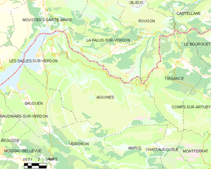
Эгин
- коммуна во Франции
Hiking in Эгин
Aiguines is a charming village located in the Var department of the Provence-Alpes-Côte d'Azur region in southeastern France. It's perched on a cliff overlooking the stunning Lac de Sainte-Croix and serves as a popular gateway to the surrounding natural beauty of the Verdon Regional Natural Park. Here are some key highlights for hiking in and around Aiguines:...
- Страна:
- Почтовый код: 83630
- Координаты: 43° 46' 33" N, 6° 14' 37" E
- GPS треки (wikiloc): [Ссылка]
- Площадь: 114.33 кв.км
- Население: 271
- Веб сайт: [Ссылка]


Ком-сюр-Артюби
- коммуна во Франции
Hiking in Ком-сюр-Артюби
Comps-sur-Artuby, located in the Var department of the Provence-Alpes-Côte d'Azur region in southeastern France, is a charming village set amidst stunning natural landscapes, making it an excellent destination for hikers. The area is characterized by its dramatic gorges, rolling hills, and rich biodiversity....
- Страна:
- Почтовый код: 83840
- Координаты: 43° 42' 36" N, 6° 30' 32" E
- GPS треки (wikiloc): [Ссылка]
- Площадь: 63.49 кв.км
- Население: 378


Шатодубль
- коммуна департамента Вар, Франция
Hiking in Шатодубль
Châteaudouble is a charming village in the Var department of the Provence-Alpes-Côte d'Azur region in southeastern France. This area is known for its stunning natural landscapes, picturesque villages, and hiking opportunities....
- Страна:
- Почтовый код: 83300
- Координаты: 43° 35' 51" N, 6° 27' 3" E
- GPS треки (wikiloc): [Ссылка]
- Площадь: 40.91 кв.км
- Население: 466