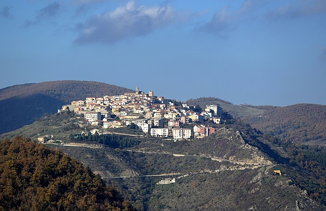
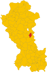
Тривиньо (Trivigno, Trivigno)
.svg)
- коммуна Италии
 Hiking in Тривиньо
Trivigno might not be widely recognized as a hiking destination, but it's an area with picturesque landscapes and opportunities for outdoor exploration in the surrounding regions of Italy. Here’s what you might consider when planning a hiking trip in and around Trivigno:
Natural Landscape
- Scenic Views: Trivigno is located in the Basilicata region, which boasts rolling hills, rugged terrain, and beautiful valleys. These landscapes can provide a stunning backdrop for your hikes.
- Flora and Fauna: The area is rich in biodiversity, with opportunities to see various plant species and wildlife endemic to the region.
Hiking Routes
- Local Trails: While specific marked trails in Trivigno may not be well-documented, there are generally country roads and paths that are popular among locals for walking and hiking. Exploring these can lead to hidden gems and breathtaking views.
- Nearby Parks: Consider visiting the nearby Pollino National Park or the Cilento and Vallo di Diano National Park, both of which offer established hiking trails and stunning natural beauty.
Recommendations
- Best Time to Hike: Spring and fall are ideal for hiking in this region, as the temperatures are milder and the scenery is particularly beautiful with blooming flowers or autumn foliage.
- Preparation: Make sure to bring adequate supplies such as water, snacks, a map, and gear suited for hiking. Having a local guide or doing a bit of research on trails can enhance your experience.
- Cultural Aspects: Embrace the local culture by taking time to explore Trivigno itself, including its historic sites and local cuisine.
Safety Tips
- Always inform someone about your hiking plans.
- Check the weather before setting out.
- Wear appropriate footwear to navigate varying terrains.
- Consider bringing a first-aid kit.
By exploring the local trails and the surrounding natural parks, you can enjoy a fulfilling hiking experience in the Trivigno area. Happy hiking!
- Страна:

- Почтовый код: 85018
- Телефонный код: 0971
- Код автомобильного номера: PZ
- Координаты: 40° 35' 0" N, 15° 59' 0" E


- GPS треки (wikiloc): [Ссылка]
- Высота над уровнем моря: 735 м m
- Площадь: 26 кв.км
- Население: 660
- Веб сайт: http://www.comunetrivigno.gov.it
- Википедия русская: wiki(ru)
- Википедия английская: wiki(en)
- Википедия национальная: wiki(it)
- Хранилище Wikidata: Wikidata: Q52688
- Катеория в википедии: [Ссылка]
- код Freebase: [/m/0fh41k]
- код GeoNames: Альт: [6537640]
- код VIAF: Альт: [237436860]
- ID отношения в OpenStreetMap: [40607]
- код ISTAT: 076093
- кадастровый код Италии: L439
Граничит с регионами:

Альбано-ди-Лукания
- коммуна Италии
Hiking in Альбано-ди-Лукания
Albano di Lucania is a picturesque village located in the Basilicata region of southern Italy, surrounded by the stunning landscapes of the Apennine Mountains. The area offers a variety of hiking opportunities that cater to different skill levels, allowing hikers to explore its natural beauty, historical sites, and local culture....
- Страна:
- Почтовый код: 85010
- Телефонный код: 0971
- Код автомобильного номера: PZ
- Координаты: 40° 35' 0" N, 16° 2' 0" E
- GPS треки (wikiloc): [Ссылка]
- Высота над уровнем моря: 899 м m
- Площадь: 55.87 кв.км
- Население: 1409
- Веб сайт: [Ссылка]


Анци
- коммуна Италии
Hiking in Анци
Anzi is a charming village located in the Basilicata region of southern Italy, nestled in the heart of the Apennine mountains. The area surrounding Anzi offers a variety of hiking opportunities that showcase the stunning landscapes, rich biodiversity, and cultural heritage of Basilicata....
- Страна:
- Почтовый код: 85010
- Телефонный код: 0971
- Код автомобильного номера: PZ
- Координаты: 40° 31' 0" N, 15° 55' 0" E
- GPS треки (wikiloc): [Ссылка]
- Высота над уровнем моря: 1067 м m
- Площадь: 77.1 кв.км
- Население: 1648
- Веб сайт: [Ссылка]
Бриндизи-Монтанья
- коммуна Италии
Hiking in Бриндизи-Монтанья
Brindisi Montagna, located in the Basilicata region of southern Italy, is a great destination for hiking enthusiasts, thanks to its stunning natural landscapes, rich biodiversity, and historical significance. Here’s what you need to know about hiking in this beautiful area:...
- Страна:
- Почтовый код: 85010
- Телефонный код: 0971
- Код автомобильного номера: PZ
- Координаты: 40° 37' 0" N, 15° 56' 0" E
- GPS треки (wikiloc): [Ссылка]
- Высота над уровнем моря: 800 м m
- Площадь: 59.88 кв.км
- Население: 881
- Веб сайт: [Ссылка]

Кастельмеццано
- коммуна Италии
Hiking in Кастельмеццано
Castelmezzano is a charming village located in the Basilicata region of southern Italy, known for its stunning scenery and outdoor activities, particularly hiking. Nestled in the Lucanian Dolomites, the area features dramatic rock formations, picturesque valleys, and lush landscapes, making it a popular destination for hikers and nature enthusiasts....
- Страна:
- Почтовый код: 85010
- Телефонный код: 0971
- Код автомобильного номера: PZ
- Координаты: 40° 32' 0" N, 16° 3' 0" E
- GPS треки (wikiloc): [Ссылка]
- Высота над уровнем моря: 750 м m
- Площадь: 33.91 кв.км
- Население: 789
- Веб сайт: [Ссылка]