Туоро-суль-Тразимено (Tuoro sul Trasimeno, Tuoro sul Trasimeno)
.svg)
- коммуна Италии
 Hiking in Туоро-суль-Тразимено
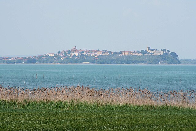
Tuoro sul Trasimeno, located in the province of Perugia in the Umbria region of Italy, is a beautiful destination for hiking enthusiasts. Nestled near Lake Trasimeno, the area offers diverse landscapes, historic sites, and a rich natural environment.
Hiking Trails and Areas:
-
Lake Trasimeno: The shores of Lake Trasimeno provide a serene backdrop for hiking. There’s a lovely trail around the lake that allows hikers to appreciate the views and the surrounding nature, including charming villages and local wildlife.
-
Natural Reserves: The nearby Isola Maggiore and Isola Polvese are accessible by ferry from Tuoro and offer wonderful hiking opportunities with trails that explore the islands’ natural beauty and historic sites, such as ancient monasteries and fishing villages.
-
Mount Tezio: A bit further afield, the trails around Mount Tezio offer more challenging hikes, with stunning views over the valley. The area is ideal for those looking for a more rugged hiking experience.
-
Monte Colognola: Another nearby mountain that features well-marked trails, perfect for day hikes. The paths wind through woods and open landscapes, providing beautiful panoramas of the region.
What to Expect:
-
Scenic Views: Trails in the area offer stunning views of Lake Trasimeno, rolling hills, vineyards, and olive groves.
-
Flora and Fauna: Hikers can encounter various plant species, ancient trees, and potentially catch sight of local wildlife.
-
Historical Sites: Hike to visit nearby castles, historical ruins, and charming villages, enriching your hiking experience with cultural insights.
Tips for Hiking in Tuoro sul Trasimeno:
-
Start Early: To make the most of your day and avoid the heat, especially in summer months.
-
Stay Hydrated: Carry enough water, especially on longer hikes.
-
Footwear: Proper hiking boots are essential for uneven terrain.
-
Local Weather: Be mindful of the local weather conditions, as they can change rapidly in the region.
-
Map and GPS: While many trails are well marked, having a map or GPS device can enhance your experience.
Conclusion:
Hiking in Tuoro sul Trasimeno offers a delightful combination of nature, history, and scenic beauty. Whether you’re a casual walker or an experienced hiker, the area is sure to provide memorable experiences. Don’t forget your camera to capture the breathtaking views!
- Страна:

- Почтовый код: 06069
- Телефонный код: 075
- Код автомобильного номера: PG
- Координаты: 43° 12' 25" N, 12° 4' 29" E


- GPS треки (wikiloc): [Ссылка]
- Высота над уровнем моря: 309 м m
- Площадь: 55.89 кв.км
- Население: 3769
- Веб сайт: http://www.comune.tuoro-sul-trasimeno.pg.it/
- Википедия русская: wiki(ru)
- Википедия английская: wiki(en)
- Википедия национальная: wiki(it)
- Хранилище Wikidata: Wikidata: Q20623
- Галерея изображений в википедии: [Ссылка]
- Катеория в википедии: [Ссылка]
- код Freebase: [/m/0gm2mz]
- код GeoNames: Альт: [6536884]
- код VIAF: Альт: [150819438]
- ID отношения в OpenStreetMap: [42367]
- код GND: Альт: [4515087-4]
- WOEID: [12682289]
- UN/LOCODE: [ITTYB]
- код ISTAT: 054055
- кадастровый код Италии: L466
Граничит с регионами:

Кастильоне-дель-Лаго
- Коммуна в Италии, располагается в регионе Умбрия, подчиняется административному центру Перуджа.
Hiking in Кастильоне-дель-Лаго
Castiglione del Lago is a charming town located on the shores of Lake Trasimeno in the Umbria region of Italy. It's a beautiful destination for hiking enthusiasts, offering scenic landscapes, historical sites, and a variety of terrains....
- Страна:
- Почтовый код: 06061
- Телефонный код: 075
- Код автомобильного номера: PG
- Координаты: 43° 7' 38" N, 12° 2' 43" E
- GPS треки (wikiloc): [Ссылка]
- Высота над уровнем моря: 304 м m
- Площадь: 205.26 кв.км
- Население: 15479
- Веб сайт: [Ссылка]


Лишиано-Никконе
- коммуна Италии
Hiking in Лишиано-Никконе
Lisciano Niccone is a small, picturesque village located in the province of Perugia, part of the Umbria region in Italy. It is situated near the border with Tuscany, offering beautiful landscapes, rolling hills, and a rich historical backdrop. Hiking in this area can be a delightful experience, thanks to the stunning natural scenery and the tranquil environment....
- Страна:
- Почтовый код: 06060
- Телефонный код: 075
- Код автомобильного номера: PG
- Координаты: 43° 15' 0" N, 12° 9' 0" E
- GPS треки (wikiloc): [Ссылка]
- Высота над уровнем моря: 314 м m
- Площадь: 35.18 кв.км
- Население: 607
- Веб сайт: [Ссылка]


Маджоне
- коммуна Италии
Hiking in Маджоне
Magione, located in the Umbria region of Italy, is a charming town situated near the western shore of Lake Trasimeno, surrounded by beautiful landscapes, vineyards, and charming rural areas. While Magione itself is not a renowned hiking destination, it offers access to a variety of trails and outdoor activities that are popular with locals and visitors alike....
- Страна:
- Почтовый код: 06063
- Телефонный код: 075
- Код автомобильного номера: PG
- Координаты: 43° 8' 30" N, 12° 12' 42" E
- GPS треки (wikiloc): [Ссылка]
- Высота над уровнем моря: 299 м m
- Площадь: 129.73 кв.км
- Население: 14815
- Веб сайт: [Ссылка]


Пассиньяно-суль-Тразимено
- коммуна Италии
Hiking in Пассиньяно-суль-Тразимено
Passignano sul Trasimeno is a charming town located on the shores of Lake Trasimeno in Umbria, Italy. Its picturesque setting and surrounding landscapes offer great opportunities for hiking and outdoor activities. Here are some highlights for hiking in the area:...
- Страна:
- Почтовый код: 06065
- Телефонный код: 075
- Код автомобильного номера: PG
- Координаты: 43° 11' 0" N, 12° 8' 0" E
- GPS треки (wikiloc): [Ссылка]
- Высота над уровнем моря: 289 м m
- Площадь: 81.33 кв.км
- Население: 5712
- Веб сайт: [Ссылка]


Кортона
- город и коммуна в Тоскане, Италия
Hiking in Кортона
Cortona, a charming hilltop town in Tuscany, Italy, is known not only for its historical architecture and stunning views but also for its scenic hiking opportunities. Here are some key points about hiking in and around Cortona:...
- Страна:
- Почтовый код: 52044
- Телефонный код: 0575
- Код автомобильного номера: AR
- Координаты: 43° 16' 32" N, 11° 59' 17" E
- GPS треки (wikiloc): [Ссылка]
- Высота над уровнем моря: 494 м m
- Площадь: 342.97 кв.км
- Население: 22057
- Веб сайт: [Ссылка]