Уккермарк (Uckermark District, Landkreis Uckermark)

 Hiking in Уккермарк
Hiking in the Uckermark district, located in the northeastern part of Germany, is a delight for nature enthusiasts. This picturesque region is characterized by its rolling landscapes, serene lakes, and lush forests, making it an ideal destination for outdoor exploration.
Key Features of Hiking in Uckermark:
-
Diverse Terrain: Uckermark offers a mix of terrain, including flat plains, heaths, and forested areas. The varied landscapes provide different hiking experiences suitable for all skill levels.
-
Nature Reserves: The region is home to several nature reserves and parks, such as the Uckermärkische Seen Nature Park. These areas are great for hiking and offer opportunities to observe local wildlife, including a variety of bird species.
-
Scenic Trails: The trails in Uckermark range from easy to moderate difficulty. Notable hiking routes include the "Havelland-Wanderweg" and local circular trails that allow hikers to explore the countryside. You can find well-marked paths and signposts to guide you along the way.
-
Lakes and Waterways: Uckermark is dotted with numerous lakes, such as the Käbelicksee and the Pälitzsee. Many trails lead to the shores of these tranquil bodies of water, offering lovely spots for resting and enjoying the scenery.
-
Cultural Attractions: While hiking, you might encounter charming villages, historical sites, and cultural landmarks. Don't miss the opportunity to explore local traditions and cuisine in the quaint towns along your route.
-
Best Seasons to Visit: Spring and autumn are ideal for hiking in Uckermark due to mild weather, blooming wildflowers, and vibrant fall colors. However, summer also has its charms, with longer daylight hours allowing for extended hikes.
-
Hiking Tips:
- Always carry enough water and snacks for your hike.
- Wear comfortable, sturdy footwear suitable for varying terrain.
- Keep a map or a mobile device with trail apps handy, as some paths can be less well-marked.
-
Accessibility: Many trails are accessible and can accommodate families with children or less experienced hikers. Additionally, public transport options connect some of the more popular starting points.
Uckermark offers a unique blend of tranquility and adventure for hikers looking to escape into nature and enjoy the peaceful rural landscape of Brandenburg. Whether you're a seasoned backpacker or just looking for a leisurely stroll, the region promises a refreshing outdoor experience.
- Страна:

- Столица: Пренцлау
- Код автомобильного номера: ANG; PZ; SDT; TP; UM
- Координаты: 53° 15' 0" N, 13° 52' 0" E


- GPS треки (wikiloc): [Ссылка]
- Высота над уровнем моря: 20 м m
- Площадь: 3058.08 кв.км
- Население: 121326
- Веб сайт: http://landkreis.uckermark.de/
- Википедия русская: wiki(ru)
- Википедия английская: wiki(en)
- Википедия национальная: wiki(de)
- Хранилище Wikidata: Wikidata: Q6109
- Катеория в википедии: [Ссылка]
- Карты в википедии: [Ссылка]
- код Freebase: [/m/015xdx]
- код GeoNames: Альт: [3249091]
- ID отношения в OpenStreetMap: [62537]
- код GND: Альт: [4061353-7]
- идентификатор местоположения ArchINFORM: [4201]
- код темы Quora: [Uckermark]
- код TGN: [7076933]
- код ISNI: Альт: [0000 0004 0427 6434]
- код NUTS: [DE40I]
- код района Германии: 12073
Включает регионы:


Шведт
- город в Бранденбурге, Германия
Hiking in Шведт
Schwedt, located in northeastern Germany near the Oder River, offers a range of outdoor activities, including hiking. The landscape around Schwedt is characterized by beautiful forests, rivers, and wetlands, making it an excellent destination for nature enthusiasts....
- Страна:
- Почтовый код: 16303
- Телефонный код: 033336; 03332
- Координаты: 53° 3' 47" N, 14° 16' 59" E
- GPS треки (wikiloc): [Ссылка]
- Высота над уровнем моря: 6 м m
- Площадь: 200.12 кв.км
- Население: 30075
- Веб сайт: [Ссылка]
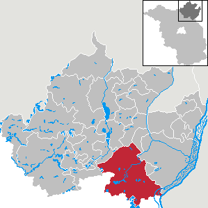
Gartz
Hiking in Gartz
Gartz (Amt) is a picturesque municipality located in the Uckermark district of Brandenburg, Germany. It's characterized by its scenic landscapes, including forests, rivers, and historic villages, making it an appealing destination for hiking enthusiasts....
Amt Oder-Welse
Hiking in Amt Oder-Welse
Hiking in the Oder-Welse region, which lies in northeastern Germany along the Oder River, offers a unique experience enveloped in natural beauty and rich biodiversity. The area is characterized by its lush landscapes, meandering rivers, and diverse ecosystems, making it perfect for both novice and experienced hikers....
- Страна:
- Координаты: 53° 3' 56" N, 14° 5' 24" E
- GPS треки (wikiloc): [Ссылка]
- Площадь: 168.12 кв.км
- Население: 5431
- Веб сайт: [Ссылка]

Amt Brüssow
Hiking in Amt Brüssow
Brüssow, located in the Uckermark region of Germany, offers a scenic backdrop for hiking enthusiasts. This area features a mix of natural landscapes, including forests, fields, and small lakes, making it appealing for outdoor activities....
- Страна:
- Столица: Брюссов
- Координаты: 53° 23' 0" N, 14° 4' 0" E
- GPS треки (wikiloc): [Ссылка]
- Население: 4623
- Веб сайт: [Ссылка]
Amt Gramzow
Hiking in Amt Gramzow
Gramzow is located in the Uckermark district of Brandenburg, Germany. The area is characterized by its picturesque landscapes, including forests, fields, and lakes, making it a lovely destination for hiking enthusiasts....
Amt Gerswalde
Hiking in Amt Gerswalde
Gerswalde, located in the Uckermark district of Brandenburg, Germany, is a beautiful area for hiking, especially for those who appreciate nature, forests, and lakes. Here are some highlights you can expect during your hiking experience in Gerswalde:...
- Страна:
- Почтовый код: 17268
- Координаты: 53° 7' 0" N, 13° 44' 0" E
- GPS треки (wikiloc): [Ссылка]
- Население: 4659
- Веб сайт: [Ссылка]

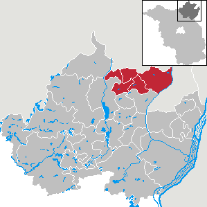
Ангермюнде
- город в Германии
Hiking in Ангермюнде
Angermünde is a charming town located in the Uckermark region of Brandenburg, Germany. It's an excellent destination for hiking enthusiasts, offering access to beautiful natural landscapes and a variety of trails that cater to different skill levels. Here are some highlights and tips for hiking in and around Angermünde:...
- Страна:
- Почтовый код: 16278
- Телефонный код: 03331
- Координаты: 53° 2' 0" N, 14° 0' 0" E
- GPS треки (wikiloc): [Ссылка]
- Высота над уровнем моря: 50 м m
- Площадь: 324.21 кв.км
- Население: 13837
- Веб сайт: [Ссылка]


Темплин
Hiking in Темплин
Templin, a charming town located in Brandenburg, Germany, offers a variety of hiking opportunities for outdoor enthusiasts. The surrounding area is rich in natural beauty, with scenic landscapes that include forests, lakes, and rivers. Here are some highlights for hiking in and around Templin:...
- Страна:
- Почтовый код: 17268
- Телефонный код: 039885; 039883; 039882; 03987
- Координаты: 53° 7' 0" N, 13° 30' 0" E
- GPS треки (wikiloc): [Ссылка]
- Высота над уровнем моря: 60 м m
- Площадь: 377.01 кв.км
- Население: 15974
- Веб сайт: [Ссылка]


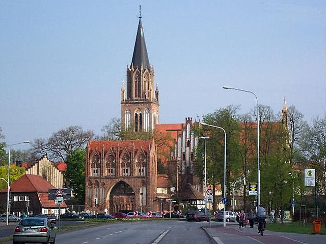
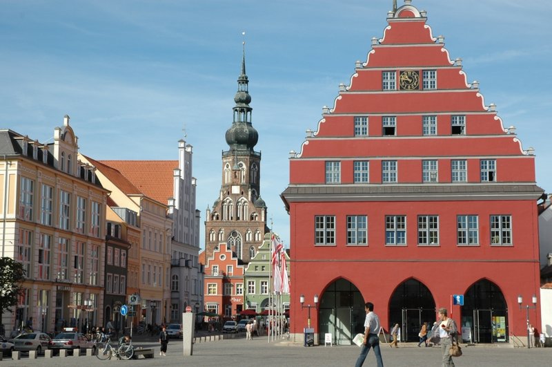
Пренцлау
Hiking in Пренцлау
Prenzlau, located in the Uckermark region of Germany, offers a charming experience for hikers with its beautiful landscapes and picturesque surroundings. Here are some highlights and tips for hiking in and around Prenzlau:...
- Страна:
- Почтовый код: 17291
- Телефонный код: 039851; 03984
- Координаты: 53° 19' 0" N, 13° 52' 0" E
- GPS треки (wikiloc): [Ссылка]
- Высота над уровнем моря: 30 м m
- Площадь: 142.96 кв.км
- Население: 19110
- Веб сайт: [Ссылка]
Бойценбургер-Ланд
Hiking in Бойценбургер-Ланд
Boitzenburger Land, located in the Uckermark district of Brandenburg, Germany, offers a variety of hiking opportunities that showcase its picturesque landscapes, rich natural heritage, and cultural sites. This region is characterized by its rolling hills, forests, lakes, and charming villages, making it a perfect destination for outdoor enthusiasts....
- Страна:
- Почтовый код: 17268
- Телефонный код: 039889; 039885; 039884
- Код автомобильного номера: UM
- Координаты: 53° 16' 0" N, 13° 36' 0" E
- GPS треки (wikiloc): [Ссылка]
- Высота над уровнем моря: 107 м m
- Площадь: 215.90 кв.км
- Население: 3151
- Веб сайт: [Ссылка]
Нордвестуккермарк
Hiking in Нордвестуккермарк
Nordwestuckermark, located in the northern part of Brandenburg, Germany, offers a beautiful setting for hiking enthusiasts. The region is known for its diverse landscapes, which include forests, lakes, and picturesque villages. Here are some highlights and tips for hiking in this area:...
- Страна:
- Почтовый код: 17291
- Телефонный код: 039859; 039855; 039853; 039852; 03984
- Код автомобильного номера: UM
- Координаты: 53° 22' 59" N, 13° 40' 0" E
- GPS треки (wikiloc): [Ссылка]
- Высота над уровнем моря: 93 м m
- Площадь: 253.14 кв.км
- Население: 4248
- Веб сайт: [Ссылка]


Уккерланд
Hiking in Уккерланд
Uckerland, located in the northeastern part of Germany in the state of Brandenburg, offers a variety of hiking opportunities that allow you to explore its natural beauty and historical sites. Here are some highlights for hiking in the region:...
- Страна:
- Почтовый код: 17337
- Телефонный код: 039753; 039752; 039745
- Код автомобильного номера: UM
- Координаты: 53° 27' 0" N, 13° 48' 0" E
- GPS треки (wikiloc): [Ссылка]
- Высота над уровнем моря: 82 м m
- Площадь: 166.19 кв.км
- Население: 2664
- Веб сайт: [Ссылка]

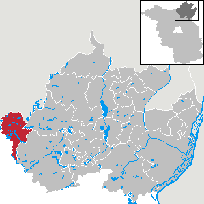
Лихен
Hiking in Лихен
Lychen is a charming town located in the Uckermark region of Brandenburg, Germany. It's known for its beautiful lakes, forests, and rich natural landscapes, making it an excellent destination for hiking enthusiasts. Here are some highlights and tips for hiking in and around Lychen:...
- Страна:
- Почтовый код: 17279
- Телефонный код: 039888; 033087
- Код автомобильного номера: UM
- Координаты: 53° 12' 11" N, 13° 19' 10" E
- GPS треки (wikiloc): [Ссылка]
- Высота над уровнем моря: 59 м m
- Площадь: 111.99 кв.км
- Население: 3207
- Веб сайт: [Ссылка]
Граничит с регионами:

Мекленбург-Зеенплате
- земельный район в земле Германии Мекленбург-Передняя Померания
Hiking in Мекленбург-Зеенплате
Mecklenburgische Seenplatte, located in northeastern Germany, is a stunning region known for its many lakes, rivers, and expansive forests, making it an excellent destination for hiking enthusiasts. Here are some key highlights about hiking in this beautiful area:...
- Страна:
- Столица: Нойбранденбург
- Код автомобильного номера: WRN; RM; NZ; MÜR; MST; MSE; MC; DM; AT
- Координаты: 53° 33' 0" N, 12° 58' 48" E
- GPS треки (wikiloc): [Ссылка]
- Высота над уровнем моря: 57 м m
- Площадь: 5468.00 кв.км
- Население: 261733
- Веб сайт: [Ссылка]

Передняя Померания-Грайфсвальд
- район в Германии
Hiking in Передняя Померания-Грайфсвальд
Vorpommern-Greifswald, located in northeastern Germany, is a fantastic destination for hikers due to its diverse landscapes, rich natural beauty, and well-maintained trails. Here’s an overview of what you can expect when hiking in this region:...
- Страна:
- Столица: Грайфсвальд
- Код автомобильного номера: WLG; VG; UEM; SBG; PW; GW; ANK
- Координаты: 53° 45' 36" N, 13° 53' 24" E
- GPS треки (wikiloc): [Ссылка]
- Высота над уровнем моря: 1 м m
- Площадь: 3927 кв.км
- Население: 237374
Иккер-Рандов
Hiking in Иккер-Рандов
Uecker-Randow is a region in northeastern Germany, known for its picturesque landscapes, including forests, rivers, and lakes. The area is part of the state of Mecklenburg-Western Pomerania and offers a range of hiking opportunities suitable for various skill levels. Here are some highlights and tips for hiking in the Uecker-Randow region:...
- Страна:
- Код автомобильного номера: UER
- Координаты: 53° 34' 48" N, 14° 0' 0" E
- GPS треки (wikiloc): [Ссылка]
- Площадь: 1635 кв.км
- Население: 72137
Мекленбург-Штрелиц
Hiking in Мекленбург-Штрелиц
Mecklenburg-Strelitz is a beautiful district in the state of Mecklenburg-Vorpommern in northern Germany, known for its picturesque landscapes, serene lakes, and lush forests. It offers many hiking opportunities that cater to various skill levels and preferences. Here’s a brief overview of what you can expect when hiking in this region:...
- Страна:
- Код автомобильного номера: MST
- Координаты: 53° 25' 12" N, 13° 15' 0" E
- GPS треки (wikiloc): [Ссылка]
Барним
- район Германии
Hiking in Барним
Barnim, located in Brandenburg, Germany, offers a great variety of hiking opportunities, thanks to its stunning natural landscapes, forests, and historical sites. Here are some key highlights of hiking in the Barnim region:...
- Страна:
- Код автомобильного номера: EW; BER; BAR
- Координаты: 52° 50' 0" N, 13° 45' 0" E
- GPS треки (wikiloc): [Ссылка]
- Высота над уровнем моря: 32 м m
- Площадь: 1.49 кв.км
- Население: 173193
- Веб сайт: [Ссылка]
Верхний Хафель
Hiking in Верхний Хафель
Oberhavel is a beautiful district located in the state of Brandenburg, Germany, known for its picturesque landscapes, lush forests, and numerous lakes. It's a fantastic destination for hiking enthusiasts. Here are some key points to consider when hiking in Oberhavel:...
- Страна:
- Код автомобильного номера: OHV
- Координаты: 52° 53' 0" N, 13° 15' 0" E
- GPS треки (wikiloc): [Ссылка]
- Высота над уровнем моря: 67 м m
- Площадь: 1795.77 кв.км
- Население: 202162
- Веб сайт: [Ссылка]