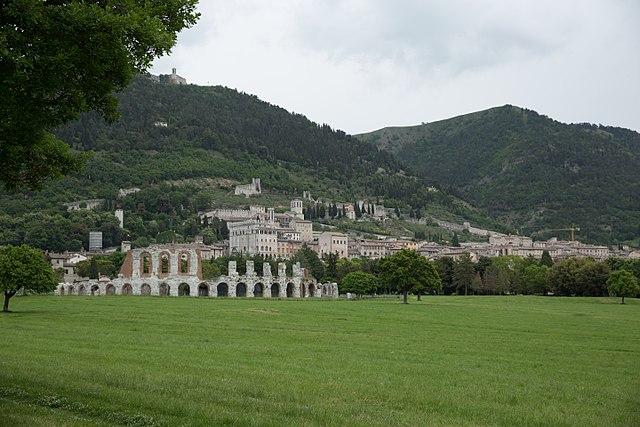
Умбертиде (Umbertide, Umbertide)
.svg)
- коммуна Италии
 Hiking in Умбертиде
Umbertide, located in the Umbria region of Italy, offers a picturesque setting for hiking enthusiasts, with its rolling hills, lush countryside, and charming medieval villages. Here are some highlights and tips for hiking in and around Umbertide:
Scenic Trails
-
Sentiero degli Ulivi: This trail winds through olive groves and offers stunning views of the Tiber Valley. It's a relatively easy hike, suitable for families and beginner hikers.
-
Monte Tezio: Located nearby, this area offers more challenging hikes with rewarding panoramic views from the summit. Look for trails that lead through the dense woods and rocky outcrops.
-
Cascate di Rio Rancio: A lovely hike that takes you to beautiful waterfalls. The path is serene and set in a natural reserve, making it perfect for a peaceful day in nature.
Flora and Fauna
The area around Umbertide is rich in biodiversity. As you hike, you may encounter various species of birds, wildflowers, and even some local wildlife. Early spring is especially beautiful with blooming wildflowers.
Cultural Experiences
In addition to the natural beauty, the area is dotted with historic sites and charming villages. Don’t miss the chance to explore Umbertide itself, with its medieval architecture, churches, and local food. Some trails connect various villages, allowing for a cultural hiking experience.
Practical Tips
- Season: The best time to hike in Umbertide is during spring (April to June) and fall (September to October) when temperatures are mild and the scenery is at its peak.
- Gear: Wear sturdy hiking shoes and bring plenty of water, sunscreen, and snacks. A good map or GPS device is also advisable for some of the more remote trails.
- Local Guidance: Consider joining guided hikes or local hiking groups to explore lesser-known routes and gain insights into the region's history and ecology.
Conclusion
Hiking in Umbertide is an enriching experience that combines natural beauty with cultural heritage. Whether you're a seasoned hiker or a beginner, you'll find trails that suit your preference while enjoying the stunning landscapes and delightful Italian atmosphere.
- Страна:

- Почтовый код: 06019
- Телефонный код: 075
- Код автомобильного номера: PG
- Координаты: 43° 18' 20" N, 12° 20' 12" E


- GPS треки (wikiloc): [Ссылка]
- Высота над уровнем моря: 247 м m
- Площадь: 200.83 кв.км
- Население: 16530
- Веб сайт: http://www.comune.umbertide.it/
- Википедия русская: wiki(ru)
- Википедия английская: wiki(en)
- Википедия национальная: wiki(it)
- Хранилище Wikidata: Wikidata: Q20685
- Катеория в википедии: [Ссылка]
- код Freebase: [/m/03_4bw]
- код GeoNames: Альт: [6538618]
- код VIAF: Альт: [168455419]
- ID отношения в OpenStreetMap: [42384]
- код GND: Альт: [4216665-2]
- место в MusicBrainz: [53da1475-33dc-4773-a5d8-bdb874297116]
- UN/LOCODE: [ITUBT]
- dmoz: Альт: [Regional/Europe/Italy/Umbria/Localities/Umbertide/]
- код ISTAT: 054056
- кадастровый код Италии: D786
Граничит с регионами:


Читта-ди-Кастелло
- коммуна Италии
Hiking in Читта-ди-Кастелло
Città di Castello, located in the Umbria region of Italy, is surrounded by stunning landscapes, making it a great destination for hiking enthusiasts. Here are some key points about hiking in and around Città di Castello:...
- Страна:
- Почтовый код: 06018; 06010; 06012
- Телефонный код: 075
- Код автомобильного номера: PG
- Координаты: 43° 27' 27" N, 12° 14' 25" E
- GPS треки (wikiloc): [Ссылка]
- Высота над уровнем моря: 288 м m
- Площадь: 387.32 кв.км
- Население: 39632
- Веб сайт: [Ссылка]

Губбио
- коммуна Италии
Hiking in Губбио
Gubbio, located in the Umbria region of Italy, is surrounded by beautiful landscapes that offer numerous hiking opportunities. Known for its medieval architecture, historical significance, and stunning views, Gubbio provides both charming trails and natural beauty for hikers of all levels. Here are some highlights of hiking in this area:...
- Страна:
- Почтовый код: 06020; 06024
- Телефонный код: 075
- Код автомобильного номера: PG
- Координаты: 43° 21' 6" N, 12° 34' 38" E
- GPS треки (wikiloc): [Ссылка]
- Высота над уровнем моря: 522 м m
- Площадь: 525.78 кв.км
- Население: 31939
- Веб сайт: [Ссылка]


Лишиано-Никконе
- коммуна Италии
Hiking in Лишиано-Никконе
Lisciano Niccone is a small, picturesque village located in the province of Perugia, part of the Umbria region in Italy. It is situated near the border with Tuscany, offering beautiful landscapes, rolling hills, and a rich historical backdrop. Hiking in this area can be a delightful experience, thanks to the stunning natural scenery and the tranquil environment....
- Страна:
- Почтовый код: 06060
- Телефонный код: 075
- Код автомобильного номера: PG
- Координаты: 43° 15' 0" N, 12° 9' 0" E
- GPS треки (wikiloc): [Ссылка]
- Высота над уровнем моря: 314 м m
- Площадь: 35.18 кв.км
- Население: 607
- Веб сайт: [Ссылка]


Маджоне
- коммуна Италии
Hiking in Маджоне
Magione, located in the Umbria region of Italy, is a charming town situated near the western shore of Lake Trasimeno, surrounded by beautiful landscapes, vineyards, and charming rural areas. While Magione itself is not a renowned hiking destination, it offers access to a variety of trails and outdoor activities that are popular with locals and visitors alike....
- Страна:
- Почтовый код: 06063
- Телефонный код: 075
- Код автомобильного номера: PG
- Координаты: 43° 8' 30" N, 12° 12' 42" E
- GPS треки (wikiloc): [Ссылка]
- Высота над уровнем моря: 299 м m
- Площадь: 129.73 кв.км
- Население: 14815
- Веб сайт: [Ссылка]

Монтоне
- коммуна Италии
Hiking in Монтоне
Montone is a picturesque village situated in the Umbria region of Italy. Nestled in the hills, it offers a beautiful backdrop for hiking enthusiasts. Here are some key points to consider when hiking in and around Montone:...
- Страна:
- Почтовый код: 06014
- Телефонный код: 075
- Код автомобильного номера: PG
- Координаты: 43° 21' 39" N, 12° 19' 24" E
- GPS треки (wikiloc): [Ссылка]
- Высота над уровнем моря: 482 м m
- Площадь: 51.1 кв.км
- Население: 1642
- Веб сайт: [Ссылка]


Пассиньяно-суль-Тразимено
- коммуна Италии
Hiking in Пассиньяно-суль-Тразимено
Passignano sul Trasimeno is a charming town located on the shores of Lake Trasimeno in Umbria, Italy. Its picturesque setting and surrounding landscapes offer great opportunities for hiking and outdoor activities. Here are some highlights for hiking in the area:...
- Страна:
- Почтовый код: 06065
- Телефонный код: 075
- Код автомобильного номера: PG
- Координаты: 43° 11' 0" N, 12° 8' 0" E
- GPS треки (wikiloc): [Ссылка]
- Высота над уровнем моря: 289 м m
- Площадь: 81.33 кв.км
- Население: 5712
- Веб сайт: [Ссылка]


Пьетралунга
- коммуна Италии
Hiking in Пьетралунга
Pietralunga is a charming town located in the Umbria region of Italy, surrounded by beautiful landscapes that are ideal for hiking enthusiasts. Nestled in the hills, this area is characterized by rolling hills, lush forests, and olive groves, making it a scenic spot for outdoor activities....
- Страна:
- Почтовый код: 06026
- Телефонный код: 075
- Код автомобильного номера: PG
- Координаты: 43° 27' 0" N, 12° 26' 0" E
- GPS треки (wikiloc): [Ссылка]
- Высота над уровнем моря: 566 м m
- Площадь: 140.42 кв.км
- Население: 2079
- Веб сайт: [Ссылка]
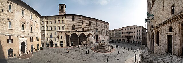

Перуджа
- коммуна в Италии
Hiking in Перуджа
Perugia, the capital of the Umbria region in Italy, is known for its rich history, vibrant culture, and beautiful landscapes. Hiking in and around Perugia offers a unique opportunity to explore both its natural beauty and historical sites. Here are some highlights and tips for hiking in this area:...
- Страна:
- Почтовый код: 06121–06135
- Телефонный код: 075
- Код автомобильного номера: PG
- Координаты: 43° 6' 44" N, 12° 23' 20" E
- GPS треки (wikiloc): [Ссылка]
- Высота над уровнем моря: 493 м m
- Площадь: 449.51 кв.км
- Население: 165683
- Веб сайт: [Ссылка]


Кортона
- город и коммуна в Тоскане, Италия
Hiking in Кортона
Cortona, a charming hilltop town in Tuscany, Italy, is known not only for its historical architecture and stunning views but also for its scenic hiking opportunities. Here are some key points about hiking in and around Cortona:...
- Страна:
- Почтовый код: 52044
- Телефонный код: 0575
- Код автомобильного номера: AR
- Координаты: 43° 16' 32" N, 11° 59' 17" E
- GPS треки (wikiloc): [Ссылка]
- Высота над уровнем моря: 494 м m
- Площадь: 342.97 кв.км
- Население: 22057
- Веб сайт: [Ссылка]