Вайонт (Vajont, Vajont)
.svg)
- коммуна Италии
 Hiking in Вайонт
Hiking in the Vajont area, located in northeastern Italy, offers stunning views and diverse landscapes, making it a popular destination for outdoor enthusiasts. Here are some key points about hiking in Vajont:
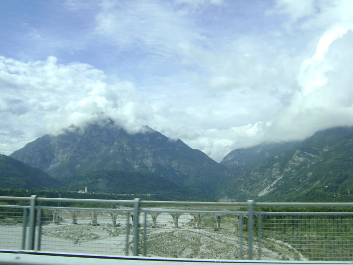
Scenic Landscape
- Vajont Dam and Lake: The Vajont Dam, one of the highest in the world, creates an impressive backdrop for hikers. The reservoir is also surrounded by lush forests and rugged mountains.
- Natural Beauty: The area is characterized by striking cliffs, valleys, and alpine meadows, providing a variety of scenic viewpoints.
Hiking Trails
- Diverse Options: There are various trails suitable for different skill levels, from easy walks suitable for families to more challenging hikes for experienced trekkers. Some trails offer paths along the banks of the Vajont Lake, while others lead into the surrounding mountains.
- Historical Significance: Many trails pass by historical sites related to the Vajont disaster of 1963, providing both a beautiful and educational experience.
Flora and Fauna
- The area is rich in biodiversity. Hikers may encounter a variety of plant species and wildlife, including birds and mammals native to the Alpine region.
Best Times to Hike
- Spring and Fall: These seasons are ideal for hiking, with mild temperatures and beautiful wildflower blooms in spring and breathtaking fall foliage.
- Summer: Early summer can be warm and inviting, though it can get crowded with tourists.
Safety and Preparation
- Weather Considerations: Always check weather conditions before heading out, as mountain weather can change rapidly.
- Equipment: Proper hiking gear is essential, including sturdy footwear, water, snacks, and a map or GPS device.
Accessibility
- The Vajont area can be reached from several nearby towns, such as Longarone and Erto, which offer additional amenities for hikers.
Conclusion
Hiking in Vajont is a wonderful way to experience the natural beauty and historical significance of the region. Whether you are looking for a leisurely walk or a strenuous hike, Vajont's trails offer something for everyone. Always remember to leave no trace and respect the natural surroundings during your adventure!
- Страна:

- Почтовый код: 33080
- Телефонный код: 0427
- Код автомобильного номера: PN
- Координаты: 46° 8' 50" N, 12° 41' 46" E


- GPS треки (wikiloc): [Ссылка]
- Высота над уровнем моря: 287 м m
- Площадь: 1.59 кв.км
- Население: 1677
- Веб сайт: http://www.comune.vajont.pn.it/
- Википедия русская: wiki(ru)
- Википедия английская: wiki(en)
- Википедия национальная: wiki(it)
- Хранилище Wikidata: Wikidata: Q53202
- Катеория в википедии: [Ссылка]
- код Freebase: [/m/08ht9m]
- код GeoNames: Альт: [6539337]
- ID отношения в OpenStreetMap: [79178]
- место в MusicBrainz: [d91d9972-eef5-44c3-a5ab-4d5cc80c1a3c]
- код ISTAT: 093052
- кадастровый код Италии: M265
Граничит с регионами:
Маниаго
- коммуна Италии
Hiking in Маниаго
Maniago, located in the Friuli Venezia Giulia region of Italy, is a charming town surrounded by beautiful natural landscapes, making it an excellent destination for hiking enthusiasts. Here are some key points about hiking in and around Maniago:...
- Страна:
- Почтовый код: 33085
- Телефонный код: 0427
- Код автомобильного номера: PN
- Координаты: 46° 10' 0" N, 12° 43' 0" E
- GPS треки (wikiloc): [Ссылка]
- Высота над уровнем моря: 283 м m
- Площадь: 69.46 кв.км
- Население: 11746
- Веб сайт: [Ссылка]

Монтереале-Вальчеллина
- коммуна Италии
Hiking in Монтереале-Вальчеллина
Montereale Valcellina, located in the Friuli Venezia Giulia region of Italy, offers stunning landscapes and a variety of hiking opportunities for outdoor enthusiasts. The area is known for its rugged mountains, lush forests, and the picturesque Valcellina valley, making it a hidden gem for hikers....
- Страна:
- Почтовый код: 33086
- Телефонный код: 0427
- Код автомобильного номера: PN
- Координаты: 46° 10' 0" N, 12° 40' 0" E
- GPS треки (wikiloc): [Ссылка]
- Высота над уровнем моря: 317 м m
- Площадь: 67.88 кв.км
- Население: 4365
- Веб сайт: [Ссылка]