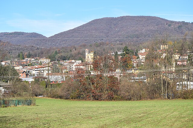
Вальганна (Valganna, Valganna)
.svg)
- коммуна Италии
 Hiking in Вальганна
Valganna is a beautiful area located in the Lombardy region of Italy, near the border with Switzerland. It offers a variety of hiking opportunities that cater to different skill levels, from beginners to experienced trekkers. The landscape is characterized by lush greenery, rolling hills, picturesque lakes, and stunning views of the surrounding mountains.
Key Hiking Areas and Trails:
-
Lake Ganna (Lago di Ganna):
- A popular spot for hikers, this lake is surrounded by forested trails and offers easy paths suitable for families. The loop trail around the lake is scenic and tranquil, perfect for a leisurely hike.
-
Monte Chiusarella:
- For those looking for a bit more challenge, the hike up Monte Chiusarella is rewarding. It offers panoramic views of the Valganna landscape and beyond. The trail can be steep in sections, so good hiking shoes are recommended.
-
Valganna Natural Park:
- This area is part of a larger protected natural reserve that offers both short and long hiking trails. You can explore various ecosystems, including forests and wetlands, and observe local wildlife.
-
Sentiero dei Carbonai:
- This historical trail traces the steps of traditional charcoal makers in the region. It connects several key points of interest and allows hikers to appreciate the area's history while enjoying the natural beauty.
Tips for Hiking in Valganna:
-
Time of Year: The best times for hiking are spring and autumn when the weather is typically mild, and the landscapes are vibrant. Summer can be warm, while winter may bring snow, affecting trail accessibility.
-
Preparation: Always check weather conditions before heading out. It’s essential to carry water, snacks, a map, and a first aid kit.
-
Footwear: Good hiking boots are recommended due to variable terrain. Trails can be rocky and uneven in places.
-
Respect Nature: Follow Leave No Trace principles to keep the environment clean and protected. Stay on marked trails to preserve wildlife habitats.
-
Local Information: Consider visiting local tourism offices for maps, trail information, and any guided hike opportunities they may offer.
Whether you’re looking for a peaceful lakeside stroll or a more strenuous mountain climb, Valganna offers a rich hiking experience amid beautiful Italian landscapes.
- Страна:

- Почтовый код: 21039
- Телефонный код: 0332
- Код автомобильного номера: VA
- Координаты: 45° 56' 0" N, 8° 50' 0" E


- GPS треки (wikiloc): [Ссылка]
- Высота над уровнем моря: 380 м m
- Площадь: 12.42 кв.км
- Население: 1623
- Веб сайт: http://www.comune.valganna.va.it
- Википедия русская: wiki(ru)
- Википедия английская: wiki(en)
- Википедия национальная: wiki(it)
- Хранилище Wikidata: Wikidata: Q40768
- Галерея изображений в википедии: [Ссылка]
- Катеория в википедии: [Ссылка]
- код Freebase: [/m/0ghzxj]
- код GeoNames: Альт: [6536130]
- код VIAF: Альт: [138573146]
- ID отношения в OpenStreetMap: [46412]
- код ISTAT: 012131
- кадастровый код Италии: L577
Граничит с регионами:

Кунардо
- коммуна Италии
Hiking in Кунардо
Cunardo, located in the province of Varese in Lombardy, Italy, is surrounded by beautiful natural landscapes, making it a great destination for hiking enthusiasts. The area is characterized by mountainous terrain, lush forests, and scenic views of the surrounding valleys and lakes....
- Страна:
- Почтовый код: 21035
- Телефонный код: 0332
- Код автомобильного номера: VA
- Координаты: 45° 56' 0" N, 8° 48' 0" E
- GPS треки (wikiloc): [Ссылка]
- Высота над уровнем моря: 450 м m
- Площадь: 6.06 кв.км
- Население: 2969
- Веб сайт: [Ссылка]


Арчизате
- коммуна Италии
Hiking in Арчизате
Arcisate, a town located in the Lombardy region of Italy, is surrounded by beautiful landscapes that provide a variety of hiking opportunities. The area is characterized by its rolling hills, lush forests, and proximity to several natural parks, making it an excellent destination for outdoor enthusiasts....
- Страна:
- Почтовый код: 21051
- Телефонный код: 0332
- Код автомобильного номера: VA
- Координаты: 45° 52' 0" N, 8° 52' 0" E
- GPS треки (wikiloc): [Ссылка]
- Высота над уровнем моря: 372 м m
- Площадь: 12.13 кв.км
- Население: 9978
- Веб сайт: [Ссылка]


Бринцио
- коммуна Италии
Hiking in Бринцио
Brinzio is a charming village located in the province of Varese, in the Lombardy region of Italy. It is situated in the foothills of the Italian Alps, which makes it a great destination for hiking enthusiasts. Here are some key points to consider when hiking in Brinzio:...
- Страна:
- Почтовый код: 21030
- Телефонный код: 0332
- Код автомобильного номера: VA
- Координаты: 45° 53' 18" N, 8° 47' 24" E
- GPS треки (wikiloc): [Ссылка]
- Высота над уровнем моря: 510 м m
- Площадь: 6.4 кв.км
- Население: 809
- Веб сайт: [Ссылка]
Кульяте-Фабьаско
- коммуна Италии
Hiking in Кульяте-Фабьаско
Cugliate-Fabiasco is a charming municipality located in the province of Varese in the Lombardy region of Italy. It is situated in the foothills of the Alps and offers a variety of hiking opportunities that showcase the stunning landscape of the area....
- Страна:
- Почтовый код: 21030
- Телефонный код: 0332
- Код автомобильного номера: VA
- Координаты: 45° 56' 52" N, 8° 49' 18" E
- GPS треки (wikiloc): [Ссылка]
- Высота над уровнем моря: 516 м m
- Площадь: 6.54 кв.км
- Население: 3121
- Веб сайт: [Ссылка]
Марцио
- коммуна в провинции Варезе, регион Ломбардия, Италия
Hiking in Марцио
Marzio is a charming village located in the province of Varese in the Lombardy region of northern Italy, situated near the border with Switzerland. The area is known for its beautiful landscapes, lush forests, and stunning views of Lake Lugano and Mount Generoso....
- Страна:
- Почтовый код: 21030
- Телефонный код: 0332
- Код автомобильного номера: VA
- Координаты: 45° 56' 0" N, 8° 52' 0" E
- GPS треки (wikiloc): [Ссылка]
- Высота над уровнем моря: 728 м m
- Площадь: 1.86 кв.км
- Население: 367
- Веб сайт: [Ссылка]
Маркироло
- коммуна Италии
Hiking in Маркироло
Marchirolo, located in the province of Varese in Lombardy, Italy, offers a beautiful setting for hiking enthusiasts. The area is characterized by its stunning natural landscapes, including mountains, forests, and hills, making it an excellent destination for outdoor activities, especially hiking....
- Страна:
- Почтовый код: 21030
- Телефонный код: 0332
- Код автомобильного номера: VA
- Координаты: 45° 57' 0" N, 8° 49' 56" E
- GPS треки (wikiloc): [Ссылка]
- Высота над уровнем моря: 500 м m
- Площадь: 5.49 кв.км
- Население: 3478
- Веб сайт: [Ссылка]


Индуно-Олона
- коммуна Италии
Hiking in Индуно-Олона
Induno Olona is a charming town located in the Lombardy region of northern Italy, nestled near the foothills of the Alps. It's a great starting point for hiking enthusiasts looking to explore the beautiful natural surroundings. Here’s what you can expect when hiking in and around Induno Olona:...
- Страна:
- Почтовый код: 21056
- Телефонный код: 0332
- Код автомобильного номера: VA
- Координаты: 45° 51' 0" N, 8° 50' 0" E
- GPS треки (wikiloc): [Ссылка]
- Высота над уровнем моря: 394 м m
- Площадь: 12.37 кв.км
- Население: 10266
- Веб сайт: [Ссылка]
Куассо-аль-Монте
- коммуна Италии
Hiking in Куассо-аль-Монте
Cuasso al Monte is a charming municipality located in the province of Varese, in the Lombardy region of northern Italy. It's nestled in the foothills of the Prealps and offers a variety of hiking opportunities that cater to different skill levels, with stunning views of the surrounding mountains and nearby Lake Lugano....
- Страна:
- Почтовый код: 21050
- Телефонный код: 0332
- Код автомобильного номера: VA
- Координаты: 45° 52' 0" N, 8° 52' 0" E
- GPS треки (wikiloc): [Ссылка]
- Высота над уровнем моря: 537 м m
- Площадь: 16.18 кв.км
- Население: 3613
- Веб сайт: [Ссылка]


Бедеро-Валькувия
- коммуна Италии
Hiking in Бедеро-Валькувия
Bedero Valcuvia is a picturesque village located in the Valcuvia valley in the Lombardy region of Italy. It is a less commercialized area that offers stunning natural landscapes, making it a great spot for hiking enthusiasts. Here are some highlights and tips for hiking in and around Bedero Valcuvia:...
- Страна:
- Почтовый код: 21039
- Телефонный код: 0332
- Код автомобильного номера: VA
- Координаты: 45° 54' 50" N, 8° 47' 40" E
- GPS треки (wikiloc): [Ссылка]
- Высота над уровнем моря: 520 м m
- Площадь: 2.56 кв.км
- Население: 602
- Веб сайт: [Ссылка]