Верчея (Verceia, Verceia)
.svg)
- коммуна Италии
 Hiking in Верчея
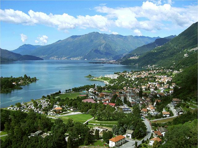
Verceia is a picturesque village located in the Lombardy region of Italy, nestled within the stunning landscape of the Valtellina Valley near the northern shores of Lake Como. The area around Verceia offers numerous hiking opportunities, showcasing beautiful views, diverse terrain, and a chance to explore the rich natural and cultural heritage of the region.
Hiking Highlights in Verceia:
-
Scenic Trails: The trails around Verceia provide a mix of difficulty levels, catering to both novice and experienced hikers. The routes often lead through lush forests, open meadows, and offer striking views of the surrounding mountains and Lake Como.
-
Natural Attractions: Hikers can explore the nearby Val di Mello, a valley known for its granite cliffs and stunning scenery. The area is also home to various alpine flora and fauna.
-
Cultural Experiences: Hikes may lead to small villages and historical sites, allowing hikers to immerse themselves in the local culture and traditions. The architecture and churches found along the trails often reflect the rich history of the area.
-
Practical Considerations:
- Ensure you have proper hiking boots, as some trails can be rocky or steep.
- Always carry enough water and snacks.
- Check the weather forecast before heading out, as conditions can change rapidly in mountainous areas.
-
Local Guides and Tours: If you're new to the area or want to learn more about the terrain and wildlife, consider hiring a local guide. Many offer tours that highlight not only the hiking experiences but also the environmental and historical significance of the region.
-
Safety Tips: Always inform someone of your hiking plans, especially if you're venturing into less populated areas. Familiarize yourself with trail markings and maps.
In summary, hiking in Verceia presents an excellent opportunity to explore the natural beauty of northern Italy, making it a great destination for outdoor enthusiasts seeking both adventure and tranquility. Enjoy the breathtaking landscapes and the serene charm of the region!
- Страна:

- Почтовый код: 23020
- Телефонный код: 0343
- Код автомобильного номера: SO
- Координаты: 46° 12' 0" N, 9° 27' 0" E


- GPS треки (wikiloc): [Ссылка]
- Высота над уровнем моря: 205 м m
- Площадь: 11.38 кв.км
- Население: 1107
- Веб сайт: http://www.comune.verceia.so.it
- Википедия русская: wiki(ru)
- Википедия английская: wiki(en)
- Википедия национальная: wiki(it)
- Хранилище Wikidata: Wikidata: Q39288
- Катеория в википедии: [Ссылка]
- код Freebase: [/m/0gj44f]
- код GeoNames: Альт: [6537106]
- код VIAF: Альт: [239211199]
- ID отношения в OpenStreetMap: [47000]
- код ISTAT: 014075
- кадастровый код Италии: L749
Граничит с регионами:
Новате-Меццола
- коммуна Италии
Hiking in Новате-Меццола
Novate Mezzola is a picturesque village located in the province of Sondrio, in the Lombardy region of northern Italy, near the beautiful Lake Mezzola. The surrounding area offers a range of hiking opportunities that cater to various skill levels, all set against the stunning backdrop of the Italian Alps....
- Страна:
- Почтовый код: 23025
- Телефонный код: 0343
- Код автомобильного номера: SO
- Координаты: 46° 13' 0" N, 9° 27' 0" E
- GPS треки (wikiloc): [Ссылка]
- Высота над уровнем моря: 212 м m
- Площадь: 99.75 кв.км
- Население: 1895
- Веб сайт: [Ссылка]
Дубино
- коммуна Италии
Hiking in Дубино
Dubino is a charming village in the province of Sondrio, located in the Lombardy region of northern Italy. Its picturesque setting, surrounded by mountains and lush landscapes, offers various hiking opportunities that cater to different skill levels. Here are some aspects to consider if you're planning to hike in the Dubino area:...
- Страна:
- Почтовый код: 23015
- Телефонный код: 0342
- Код автомобильного номера: SO
- Координаты: 46° 9' 0" N, 9° 27' 0" E
- GPS треки (wikiloc): [Ссылка]
- Высота над уровнем моря: 223 м m
- Площадь: 13.24 кв.км
- Население: 3715
- Веб сайт: [Ссылка]

Сорико
- коммуна Италии
Hiking in Сорико
Sorico is a picturesque town located in the province of Sondrio, in the Lombardy region of northern Italy. It is positioned along the shores of Lake Como and offers stunning views of the surrounding mountains and lake, making it a great destination for hikers....
- Страна:
- Почтовый код: 22010
- Телефонный код: 0344
- Код автомобильного номера: CO
- Координаты: 46° 10' 20" N, 9° 22' 53" E
- GPS треки (wikiloc): [Ссылка]
- Высота над уровнем моря: 201 м m
- Площадь: 24.44 кв.км
- Население: 1270
- Веб сайт: [Ссылка]