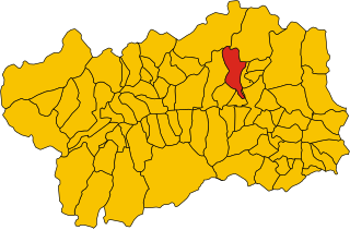
Веррей (Verrayes, Verrayes)
.svg)
- коммуна Италии
 Hiking in Веррей
Verrayes is a beautiful municipality located in the Aosta Valley region of Italy. It's known for its stunning landscapes, charming villages, and the surrounding mountains, which offer a variety of hiking opportunities suitable for different skill levels. Here are some key points about hiking in Verrayes:
Trails and Routes:
-
Verrayes to Châtillon: A popular hiking route that connects the village of Verrayes to the town of Châtillon. This route typically offers breathtaking views of the valley and the mountainous surroundings.
-
Mont Avic Natural Park: While not directly in Verrayes, it's nearby and provides a network of trails through pristine natural landscapes. Keep an eye out for the diverse flora and fauna.
-
Local Paths: There are numerous well-marked paths around Verrayes that lead you through vineyards, forests, and small rural communities. These paths often intersect with historical sites and offer a taste of local culture.
Difficulty Levels:
- Easy to Moderate Trails: Many of the trails around Verrayes are suitable for families and beginners, providing gentle elevation and good paths.
- Challenging Hikes: For more experienced hikers, there are challenging routes that lead to higher altitudes and provide stunning panoramic views.
Best Time to Hike:
- Spring (April to June): The flowers are blooming, and the weather is generally mild.
- Summer (July to August): Warm weather makes for great hiking conditions, but it's also the peak tourist season.
- Autumn (September to October): The changing colors of the leaves provide a beautiful backdrop for hikes.
Tips:
- Wear Appropriate Gear: Depending on the season, you'll want to dress in layers and wear good hiking boots.
- Stay Hydrated: Always carry enough water, especially on longer hikes.
- Check Weather Conditions: The weather can change quickly in mountain regions, so make sure to check forecasts before you set off.
- Take a Map or GPS: While trails are often well-marked, having a map or a GPS device can help you navigate less traveled paths.
Cultural Aspects:
Hiking in Verrayes not only allows you to enjoy nature but also gives you the opportunity to experience the local culture, including traditional food, wine from local vineyards, and historical landmarks.
Whether you are looking for a peaceful nature walk or a rugged mountain adventure, Verrayes has trails that can accommodate your hiking desires. Remember to respect the environment and follow Leave No Trace principles while enjoying the stunning natural beauty of the Aosta Valley!
- Страна:

- Почтовый код: 11020
- Телефонный код: 0166
- Код автомобильного номера: AO
- Координаты: 45° 46' 0" N, 7° 32' 0" E


- GPS треки (wikiloc): [Ссылка]
- Высота над уровнем моря: 1017 м m
- Площадь: 22.36 кв.км
- Население: 1303
- Веб сайт: http://www.comune.verrayes.ao.it
- Википедия русская: wiki(ru)
- Википедия английская: wiki(en)
- Википедия национальная: wiki(it)
- Хранилище Wikidata: Wikidata: Q35544
- Катеория в википедии: [Ссылка]
- Карты в википедии: [Ссылка]
- код Freebase: [/m/0ft03d]
- код GeoNames: Альт: [6542426]
- код VIAF: Альт: [238756478]
- ID отношения в OpenStreetMap: [45970]
- UN/LOCODE: [ITVRY]
- код ISTAT: 007072
- кадастровый код Италии: L783
Граничит с регионами:


Шамбав
- коммуна Италии
Hiking in Шамбав
Chambave, located in the Aosta Valley of Italy, offers scenic hiking opportunities amidst stunning Alpine landscapes. This charming village is surrounded by picturesque mountains, vineyards, and historical sites, making it a great base for outdoor enthusiasts....
- Страна:
- Почтовый код: 11023
- Телефонный код: 0166
- Код автомобильного номера: AO
- Координаты: 45° 45' 0" N, 7° 33' 0" E
- GPS треки (wikiloc): [Ссылка]
- Высота над уровнем моря: 480 м m
- Площадь: 21.54 кв.км
- Население: 937
- Веб сайт: [Ссылка]


Фенис
- коммуна Италии
Hiking in Фенис
Fénis is a picturesque village located in the Aosta Valley region of Italy, known for its stunning landscapes, rich history, and outdoor activities, making it an excellent destination for hiking enthusiasts. Here are some key points to consider when exploring hiking in Fénis:...
- Страна:
- Почтовый код: 11020
- Телефонный код: 0165
- Код автомобильного номера: AO
- Координаты: 45° 44' 5" N, 7° 29' 44" E
- GPS треки (wikiloc): [Ссылка]
- Высота над уровнем моря: 541 м m
- Площадь: 68.12 кв.км
- Население: 1818
- Веб сайт: [Ссылка]


Нюс
- коммуна Италии
Hiking in Нюс
Nus, a charming village located in the Aosta Valley region of Italy, offers some wonderful hiking opportunities. The picturesque landscape is characterized by mountains, valleys, and lush greenery, making it a great destination for outdoor enthusiasts. Here are some key points about hiking in Nus:...
- Страна:
- Почтовый код: 11020
- Телефонный код: 0165
- Код автомобильного номера: AO
- Координаты: 45° 44' 0" N, 7° 28' 0" E
- GPS треки (wikiloc): [Ссылка]
- Высота над уровнем моря: 529 м m
- Площадь: 57.36 кв.км
- Население: 2991
- Веб сайт: [Ссылка]
Сен-Дени
- коммуна Италии
Hiking in Сен-Дени
Saint-Denis in the Aosta Valley is a beautiful location for hiking, surrounded by stunning alpine landscapes and offering a variety of trails suited for different skill levels. Here are some key points about hiking in this region:...
- Страна:
- Почтовый код: 11023
- Телефонный код: 0166
- Код автомобильного номера: AO
- Координаты: 45° 45' 0" N, 7° 33' 0" E
- GPS треки (wikiloc): [Ссылка]
- Высота над уровнем моря: 820 м m
- Площадь: 11.39 кв.км
- Население: 369
- Веб сайт: [Ссылка]

Торньон
- коммуна Италии
Hiking in Торньон
Torgnon is a beautiful village located in the Aosta Valley region of Italy, nestled in the Italian Alps. It's known for its stunning landscapes, lush valleys, and pristine nature, making it an ideal destination for hiking enthusiasts. Here are some key points about hiking in Torgnon:...
- Страна:
- Почтовый код: 11020
- Телефонный код: 0166
- Код автомобильного номера: AO
- Координаты: 45° 48' 0" N, 7° 34' 0" E
- GPS треки (wikiloc): [Ссылка]
- Высота над уровнем моря: 1489 м m
- Площадь: 42.46 кв.км
- Население: 587
- Веб сайт: [Ссылка]