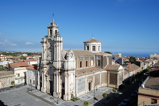
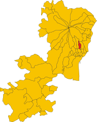
Виагранде (Viagrande, Viagrande)
- коммуна в Италии
Viagrande, located in the eastern part of Sicily, Italy, offers a beautiful hiking experience characterized by its scenic landscapes, lush vegetation, and views of Mount Etna. Here’s what you need to know about hiking in Viagrande:
Trails and Routes
-
Mount Etna: While Viagrande itself has trails, many hikers use it as a base to explore the surrounding trails on Mount Etna. Various paths lead to different craters and viewpoints. The trails vary in difficulty, from easy walks to challenging hikes.
-
Zafferana Etnea: Nearby, the town of Zafferana Etnea features trails that explore the forests and old lava flows. The “Sentiero Natura” (Nature Trail) is particularly popular, showcasing the local flora and fauna.
-
Local Trails: Viagrande has several local trails that provide a glimpse of Sicilian rural life, taking you through vineyards, citrus groves, and charming old villages. The landscape here is peaceful and less crowded compared to more popular destinations.
Scenic Views
Hiking in Viagrande allows for stunning views of both Mount Etna and the Ionian Sea. On clear days, you can enjoy sweeping vistas of the coastline and the surrounding countryside.
Flora and Fauna
The area is rich in biodiversity, with a mix of Mediterranean vegetation and unique plants that thrive in volcanic soil. You might encounter various bird species and wildlife, making it an excellent spot for nature lovers.
Best Time to Hike
The ideal seasons for hiking in and around Viagrande are spring (April to June) and fall (September to November), when the weather is mild and the trails are less crowded. Summer can be quite hot, while winter may bring snow to the higher elevations of Mount Etna.
Preparing for Your Hike
- Footwear: Ensure you have good-quality hiking boots, especially for trails on Mount Etna.
- Water: Carry plenty of water, especially during warm months.
- Sun Protection: Don’t forget sunscreen, sunglasses, and a hat, as the sun can be strong.
- Maps and Guidance: While some trails are well-marked, having a map or a guide can enhance your hiking experience, especially on more complex routes.
Conclusion
Viagrande and its surrounding areas offer a wonderful opportunity for hikers of all levels. Whether you're looking for a leisurely stroll through the countryside or a challenging ascent on Mount Etna, the region's natural beauty and rich culture make it a perfect hiking destination.
- Страна:

- Почтовый код: 95029
- Телефонный код: 095
- Код автомобильного номера: CT
- Координаты: 37° 37' 0" N, 15° 6' 0" E


- GPS треки (wikiloc): [Ссылка]
- Высота над уровнем моря: 410 м m
- Площадь: 10.09 кв.км
- Население: 8677
- Веб сайт: http://www.comune.viagrande.ct.it/
- Википедия русская: wiki(ru)
- Википедия английская: wiki(en)
- Википедия национальная: wiki(it)
- Хранилище Wikidata: Wikidata: Q478954
- Катеория в википедии: [Ссылка]
- код Freebase: [/m/0gqhvm]
- код GeoNames: Альт: [6541971]
- код VIAF: Альт: [248303624]
- ID отношения в OpenStreetMap: [39303]
- код GND: Альт: [4824838-1]
- UN/LOCODE: [ITVGE]
- код ISTAT: 087053
- кадастровый код Италии: L828
Граничит с регионами:


Цафферана-Этнея
- коммуна в Италии
Zafferana Etnea, located on the eastern slope of Mount Etna in Sicily, Italy, is a beautiful destination for hiking enthusiasts. The region is renowned for its stunning landscapes, rich biodiversity, and unique volcanic terrain. Here are some highlights and tips for hiking in Zafferana Etnea:...
- Страна:

- Почтовый код: 95019
- Телефонный код: 095
- Код автомобильного номера: CT
- Координаты: 37° 41' 0" N, 15° 6' 0" E


- GPS треки (wikiloc): [Ссылка]
- Высота над уровнем моря: 574 м m
- Площадь: 76.87 кв.км
- Население: 9607
- Веб сайт: [Ссылка]
Ачи-Бонаккорси
- коммуна в Италии
Aci Bonaccorsi is a charming village located in the province of Catania in Sicily, Italy. Surrounded by beautiful natural landscapes, it offers various opportunities for hiking and outdoor activities, especially for those interested in exploring the foothills of Mount Etna and the surrounding countryside....
- Страна:

- Почтовый код: 95020
- Телефонный код: 095
- Код автомобильного номера: CT
- Координаты: 37° 35' 44" N, 15° 6' 34" E


- GPS треки (wikiloc): [Ссылка]
- Высота над уровнем моря: 365 м m
- Площадь: 1.72 кв.км
- Население: 3529
- Веб сайт: [Ссылка]


Ачи-Сант'Антонио
- коммуна в Италии
Aci Sant'Antonio is a charming town located in Sicily, Italy, near the eastern coast and not far from Mount Etna. Although it may not be as widely recognized as some other hiking destinations, the surrounding areas offer a variety of trails and natural beauty that can be explored. Here are some insights into hiking in and around Aci Sant'Antonio:...
- Страна:

- Почтовый код: 95025
- Телефонный код: 095
- Код автомобильного номера: CT
- Координаты: 37° 36' 0" N, 15° 7' 0" E


- GPS треки (wikiloc): [Ссылка]
- Высота над уровнем моря: 302 м m
- Площадь: 14.33 кв.км
- Население: 18076
- Веб сайт: [Ссылка]
Сан-Джованни-ла-Пунта
- коммуна в Италии
 Hiking in Сан-Джованни-ла-Пунта
San Giovanni la Punta, located in the province of Catania in Sicily, Italy, offers a unique combination of natural beauty and cultural landmarks, making it an interesting area for hiking enthusiasts. The region is characterized by its proximity to Mount Etna, which is one of the most active volcanoes in the world and a UNESCO World Heritage site....
- Страна:

- Почтовый код: 95037
- Телефонный код: 095
- Код автомобильного номера: CT
- Координаты: 37° 35' 0" N, 15° 6' 0" E


- GPS треки (wikiloc): [Ссылка]
- Высота над уровнем моря: 350 м m
- Площадь: 10.85 кв.км
- Население: 23399
- Веб сайт: [Ссылка]


Трекастаньи
- коммуна в Италии
Trecastagni is a charming town located on the eastern slopes of Mount Etna in Sicily, Italy. It is an excellent base for hiking enthusiasts looking to explore the stunning landscapes of the region, particularly those related to the majestic active volcano, Mount Etna, which is known for its diverse ecosystems, unique geological features, and breathtaking views....
- Страна:

- Почтовый код: 95039
- Телефонный код: 095
- Код автомобильного номера: CT
- Координаты: 37° 37' 0" N, 15° 5' 0" E


- GPS треки (wikiloc): [Ссылка]
- Высота над уровнем моря: 586 м m
- Площадь: 19.16 кв.км
- Население: 11074
- Веб сайт: [Ссылка]
