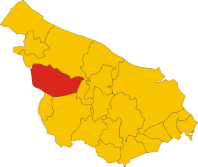
Вилла-Кастелли (Villa Castelli, Villa Castelli)
.svg)
- коммуна Италии
 Hiking in Вилла-Кастелли
Villa Castelli, located in the Apulia region of Italy, is not just known for its scenic beauty but also for its excellent opportunities for hiking and outdoor activities. Here are some details about hiking in the area:
Landscape and Terrain
The landscape around Villa Castelli features a mix of rolling hills, olive groves, and rocky outcrops. The region is characterized by its dry climate and limestone formations, which create unique hiking paths and stunning vistas. Hikers can enjoy the serene countryside, traditional masserie (farmhouses), and perhaps the sight of local wildlife.
Best Hiking Trails
While specific trails may not be well-documented, there are several routes that local guides and hiking enthusiasts recommend:
-
Olive Grove Trails: These trails wind through the ancient olive groves that are characteristic of the region. Hikers can enjoy peaceful walks while learning about the history and cultivation of olives.
-
Natural Parks: Nearby natural parks, such as the Parco Naturale Regionale Dune Costiere, offer well-marked trails that include coastal views, diverse flora and fauna, and opportunities for birdwatching.
-
Countryside Routes: Exploring the rural landscape allows for longer hikes that connect various towns in the area. These routes often include charming villages and historical sites.
Hiking Considerations
- Season: The best time for hiking in Villa Castelli is during the spring (April to June) and fall (September to October) when temperatures are mild and the landscape is lush.
- Preparation: Hikers should wear appropriate footwear, bring plenty of water, and consider a map or GPS device, as some trails may not be well-marked.
- Local Guides: Hiring a local guide can enhance the experience with insights into the flora, fauna, and culture of the region.
Additional Activities
Apart from hiking, Villa Castelli is known for its pottery and local cuisine, which can be enjoyed after a day of hiking. You might also explore historical sites and local markets to experience the vibrant culture of the region.
Safety Tips
- Always inform someone about your hiking plans and expected return time.
- Check the weather forecast before heading out, and be prepared for changes in conditions.
- Carry a first aid kit and know basic navigation skills.
With its beautiful landscapes and rich cultural heritage, hiking in Villa Castelli can be a rewarding experience. Enjoy your adventure and stay safe!
- Страна:

- Почтовый код: 72029
- Телефонный код: 0831
- Код автомобильного номера: BR
- Координаты: 40° 35' 0" N, 17° 29' 0" E


- GPS треки (wikiloc): [Ссылка]
- Высота над уровнем моря: 300 м m
- Площадь: 35.15 кв.км
- Население: 9269
- Веб сайт: http://www.comune.villacastelli.br.it
- Википедия русская: wiki(ru)
- Википедия английская: wiki(en)
- Википедия национальная: wiki(it)
- Хранилище Wikidata: Wikidata: Q51882
- Катеория в википедии: [Ссылка]
- код Freebase: [/m/0f5l9m]
- код GeoNames: Альт: [6537579]
- ID отношения в OpenStreetMap: [40603]
- место в MusicBrainz: [c374dfe6-5c69-4a71-b4ad-e4804713c4fd]
- код ISTAT: 074020
- кадастровый код Италии: L920
Граничит с регионами:


Таранто
- коммуна Италии
Hiking in Таранто
Hiking in Taranto, located in the Apulia region of Italy, offers a unique blend of natural beauty, historical sites, and coastal views. While Taranto itself is more known for its urban landscape and maritime history, there are several scenic areas nearby that are great for hiking enthusiasts....
- Страна:
- Почтовый код: 74121-74122-74123
- Телефонный код: 099
- Код автомобильного номера: TA
- Координаты: 40° 25' 5" N, 17° 14' 27" E
- GPS треки (wikiloc): [Ссылка]
- Высота над уровнем моря: 15 м m
- Площадь: 249.86 кв.км
- Население: 200385
- Веб сайт: [Ссылка]

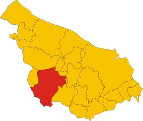
Челье-Мессапика
- коммуна Италии
Hiking in Челье-Мессапика
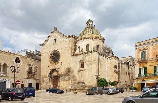
Ceglie Messapica, located in the Apulia region of Italy, is a charming destination known for its rich history, stunning landscapes, and beautiful countryside, making it a great spot for hiking enthusiasts. Here are some highlights about hiking in the area:...
- Страна:
- Почтовый код: 72013
- Телефонный код: 0831
- Код автомобильного номера: BR
- Координаты: 40° 39' 0" N, 17° 31' 0" E
- GPS треки (wikiloc): [Ссылка]
- Высота над уровнем моря: 298 м m
- Площадь: 132.02 кв.км
- Население: 19833
- Веб сайт: [Ссылка]

Франкавилла-Фонтана
- коммуна Италии
Hiking in Франкавилла-Фонтана
Francavilla Fontana is a town in the Apulia region of southern Italy, rich in history and culture, and surrounded by beautiful natural landscapes that can provide a great hiking experience. While Francavilla Fontana itself is more known for its architecture and historical sites, its surrounding areas offer opportunities for outdoor activities....
- Страна:
- Почтовый код: 72021
- Телефонный код: 0831
- Код автомобильного номера: BR
- Координаты: 40° 31' 53" N, 17° 35' 9" E
- GPS треки (wikiloc): [Ссылка]
- Высота над уровнем моря: 142 м m
- Площадь: 177.94 кв.км
- Население: 36358
- Веб сайт: [Ссылка]

Гротталье
- коммуна Италии
Hiking in Гротталье
Grottaglie, a town in the Apulia region of Italy, is known for its rich history, beautiful ceramics, and charming landscapes. While it might not be a renowned hiking destination like some of Italy's mountainous regions, it does offer some opportunities for outdoor enthusiasts to enjoy nature and explore the local countryside. Here are a few aspects to consider when hiking in and around Grottaglie:...
- Страна:
- Почтовый код: 74023
- Телефонный код: 099
- Код автомобильного номера: TA
- Координаты: 40° 32' 13" N, 17° 26' 14" E
- GPS треки (wikiloc): [Ссылка]
- Высота над уровнем моря: 133 м m
- Площадь: 102.12 кв.км
- Население: 31890
- Веб сайт: [Ссылка]


Мартина-Франка
- коммуна Италии
Hiking in Мартина-Франка
Martina Franca, located in the Apulia region of Italy, is not only known for its Baroque architecture and beautiful historic center but also offers some scenic hiking opportunities in the surrounding countryside. Here are key points regarding hiking in and around Martina Franca:...
- Страна:
- Почтовый код: 74015
- Телефонный код: 080
- Код автомобильного номера: TA
- Координаты: 40° 42' 0" N, 17° 20' 0" E
- GPS треки (wikiloc): [Ссылка]
- Высота над уровнем моря: 431 м m
- Площадь: 299.72 кв.км
- Население: 48786
- Веб сайт: [Ссылка]