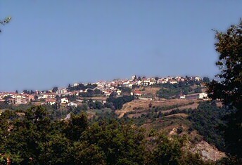
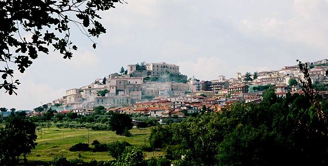
Вилламайна (Villamaina, Villamaina)
- коммуна Италии
 Hiking in Вилламайна
Villamaina is a picturesque village located in the region of Campania, Italy, surrounded by the scenic beauty of the Apennine Mountains. Hiking in this area offers a unique blend of natural landscapes, cultural heritage, and outdoor adventure.
Hiking Trails
-
Sentiero dei Lupi: This trail, often referred to as the "Wolf Path," provides a stunning opportunity to explore the local wildlife and native flora. It’s moderately challenging and offers breathtaking views of the surrounding valleys.
-
Monte Porrara Trail: A hike to Monte Porrara rewards adventurers with panoramic views of the surrounding landscapes. The trail is steep, making it suitable for more experienced hikers.
-
Creta dei Driadi: This is a less-traveled path that allows hikers to immerse themselves in nature. The area is known for its unique rock formations and diverse ecosystems.
Pro Tips
- Seasonal Considerations: Spring and early fall are ideal for hiking due to milder weather. Summer can be hot, so plan your hikes for early morning or late afternoon.
- Trail Maps: It's best to carry a detailed map or use a GPS device, as some trails may not be well marked.
- Water and Snacks: Always carry enough water and energy snacks, particularly on longer hikes.
- Footwear: Invest in good-quality hiking boots to navigate the rugged terrain safely.
Other Activities
- Cultural Exploration: Villamaina is rich in history and local culture, so take some time to explore the village itself, including its traditional architecture and cuisine.
- Photography: The scenic vistas and unique geological features provide excellent opportunities for photography.
Safety Considerations
- Always inform someone about your hiking plans.
- Check the weather before your hike, as conditions can change rapidly in mountainous areas.
By exploring the trails around Villamaina, you can enjoy an enriching experience that combines physical activity with the beauty of nature and local culture. Remember to leave no trace and respect the natural environment during your hikes. Happy hiking!
- Страна:

- Почтовый код: 83050
- Телефонный код: 0825
- Код автомобильного номера: AV
- Координаты: 40° 58' 0" N, 15° 5' 0" E


- GPS треки (wikiloc): [Ссылка]
- Высота над уровнем моря: 570 м m
- Площадь: 9.04 кв.км
- Население: 977
- Веб сайт: http://villamaina.asmenet.it
- Википедия русская: wiki(ru)
- Википедия английская: wiki(en)
- Википедия национальная: wiki(it)
- Хранилище Wikidata: Wikidata: Q55138
- Катеория в википедии: [Ссылка]
- код Freebase: [/m/0fg1bm]
- код GeoNames: Альт: [6538801]
- ID отношения в OpenStreetMap: [40965]
- код ISTAT: 064117
- кадастровый код Италии: L965
Граничит с регионами:
Фридженто
- коммуна Италии
Hiking in Фридженто
Frigento, a town in the Avellino province of Italy, is surrounded by beautiful landscapes that offer various hiking opportunities. The area is characterized by rolling hills, lush greenery, and scenic views, making it a great destination for outdoor enthusiasts....
- Страна:
- Почтовый код: 83040
- Телефонный код: 0825
- Код автомобильного номера: AV
- Координаты: 41° 0' 44" N, 15° 6' 2" E
- GPS треки (wikiloc): [Ссылка]
- Высота над уровнем моря: 911 м m
- Площадь: 38.04 кв.км
- Население: 3663
- Веб сайт: [Ссылка]
Джезуальдо
- коммуна в провинции Авеллино, регион Кампания, Италия
Hiking in Джезуальдо
Gesualdo, located in the province of Avellino in the Campania region of southern Italy, is a charming town known for its historical significance and beautiful landscapes. Hiking in and around Gesualdo can be a rewarding experience, offering scenic views, varied terrain, and opportunities to explore the region's natural beauty....
- Страна:
- Почтовый код: 83040
- Телефонный код: 0825
- Код автомобильного номера: AV
- Координаты: 41° 0' 28" N, 15° 4' 24" E
- GPS треки (wikiloc): [Ссылка]
- Высота над уровнем моря: 640 м m
- Площадь: 27.34 кв.км
- Население: 3446
- Веб сайт: [Ссылка]
Патернополи
- коммуна Италии
Hiking in Патернополи
Paternopoli, located in the province of Avellino in the Campania region of Italy, offers some beautiful hiking opportunities amidst its picturesque landscapes. Nestled in the Apennine Mountains, this area is characterized by lush greenery, rolling hills, and historic villages, making it an appealing destination for outdoor enthusiasts....
- Страна:
- Почтовый код: 83052
- Телефонный код: 0827
- Код автомобильного номера: AV
- Координаты: 40° 58' 0" N, 15° 2' 0" E
- GPS треки (wikiloc): [Ссылка]
- Высота над уровнем моря: 480 м m
- Площадь: 18.43 кв.км
- Население: 2377
- Веб сайт: [Ссылка]

Рокка-Сан-Феличе
- коммуна Италии
Hiking in Рокка-Сан-Феличе
Rocca San Felice is a beautiful village in the province of Avellino, in the Campania region of southern Italy. Known for its stunning landscapes, rich history, and vibrant natural surroundings, it offers a range of hiking opportunities for outdoor enthusiasts....
- Страна:
- Почтовый код: 83050
- Телефонный код: 0827
- Код автомобильного номера: AV
- Координаты: 40° 57' 0" N, 15° 10' 0" E
- GPS треки (wikiloc): [Ссылка]
- Высота над уровнем моря: 740 м m
- Площадь: 14.41 кв.км
- Население: 835
- Веб сайт: [Ссылка]

Сант'Анджело-дей-Ломбарди
- коммуна Италии
Hiking in Сант'Анджело-дей-Ломбарди
Sant'Angelo dei Lombardi is located in the province of Avellino in the Campania region of Italy. It's a beautiful area known for its natural landscapes, nestled in the Apennine Mountains, making it a fantastic destination for hiking enthusiasts....
- Страна:
- Почтовый код: 83054
- Телефонный код: 0827
- Код автомобильного номера: AV
- Координаты: 40° 56' 0" N, 15° 11' 0" E
- GPS треки (wikiloc): [Ссылка]
- Высота над уровнем моря: 875 м m
- Площадь: 55.11 кв.км
- Население: 4207
- Веб сайт: [Ссылка]
Торелла-дей-Ломбарди
- коммуна Италии
Hiking in Торелла-дей-Ломбарди
Torella dei Lombardi is a charming village located in the Campania region of southern Italy, nestled in the heart of the Irpinia area. Surrounded by breathtaking landscapes and rolling hills, it offers great hiking opportunities for outdoor enthusiasts. Here are some key points to consider when hiking in and around Torella dei Lombardi:...
- Страна:
- Почтовый код: 83057
- Телефонный код: 0827
- Код автомобильного номера: AV
- Координаты: 40° 56' 0" N, 15° 7' 0" E
- GPS треки (wikiloc): [Ссылка]
- Высота над уровнем моря: 666 м m
- Площадь: 26.57 кв.км
- Население: 2081
- Веб сайт: [Ссылка]