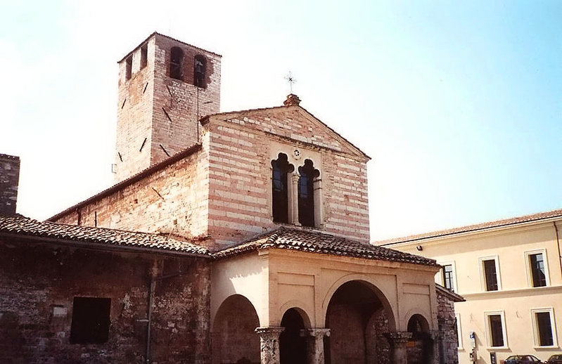
Виссо (Visso, Visso)
.svg)
- коммуна Италии
 Hiking in Виссо
Visso, a charming town located in the Marche region of Italy, is a wonderful destination for hiking enthusiasts. Nestled in the Sibillini Mountains National Park, Visso offers stunning landscapes, diverse wildlife, and a variety of well-marked trails that cater to different skill levels.
Hiking Trails and Routes
-
Valnerina Trail: This scenic route follows the Nera River and showcases beautiful valley views, rich vegetation, and opportunities to spot various wildlife. It's suitable for both beginners and families.
-
Pizzo Berro: For more experienced hikers, the trail leading to Pizzo Berro offers more challenging terrain, leading to breathtaking panoramic views of the surrounding mountains. This hike can be demanding, so be prepared for a longer trek.
-
Monte Bove: This is a more strenuous option that takes you to the summit of Monte Bove. The well-marked trail provides a great workout and rewards your efforts with spectacular vistas.
-
Sibillini Mountain Circuit: This longer trekking option connects multiple villages and allows hikers to experience the full beauty of the park. It can be tackled over several days, depending on your chosen route.
Best Time to Hike
The best seasons for hiking in Visso are spring (April to June) and autumn (September to October) when the weather is mild, and the landscapes are particularly beautiful. Summer can be quite warm, but it’s also popular with tourists, while winter may bring snow, offering opportunities for snowshoeing in the park.
Preparation Tips
- Gear: Wear sturdy hiking boots, dress in layers, and don’t forget a hat and sunscreen, especially in summer.
- Hydration and Snacks: Carry enough water and snacks, as many trails may not have facilities.
- Maps and GPS: Although trails are marked, having a map or a GPS device can be useful for navigation.
- Local Advice: Consider visiting the local tourist office in Visso for trail maps, advice, and current trail conditions.
Additional Activities
Aside from hiking, Visso is known for its beautiful architecture, traditional cuisine, and local crafts. Don't miss exploring the historical town center and enjoying local delicacies after a day on the trails.
Hiking in Visso combines natural beauty with cultural experiences, making it a fantastic outdoor destination in Italy.
- Страна:

- Почтовый код: 62039
- Телефонный код: 0737
- Код автомобильного номера: MC
- Координаты: 42° 55' 51" N, 13° 5' 18" E


- GPS треки (wikiloc): [Ссылка]
- Высота над уровнем моря: 607 м m
- Площадь: 100.4 кв.км
- Население: 1076
- Веб сайт: http://www.visso.sinp.net
- Википедия русская: wiki(ru)
- Википедия английская: wiki(en)
- Википедия национальная: wiki(it)
- Хранилище Wikidata: Wikidata: Q94986
- Галерея изображений в википедии: [Ссылка]
- Катеория в википедии: [Ссылка]
- код Freebase: [/m/0gl7f0]
- код GeoNames: Альт: [6538527]
- код VIAF: Альт: [144680484]
- ID отношения в OpenStreetMap: [42211]
- код ISTAT: 043057
- кадастровый код Италии: M078
Граничит с регионами:


Черрето-ди-Сполето
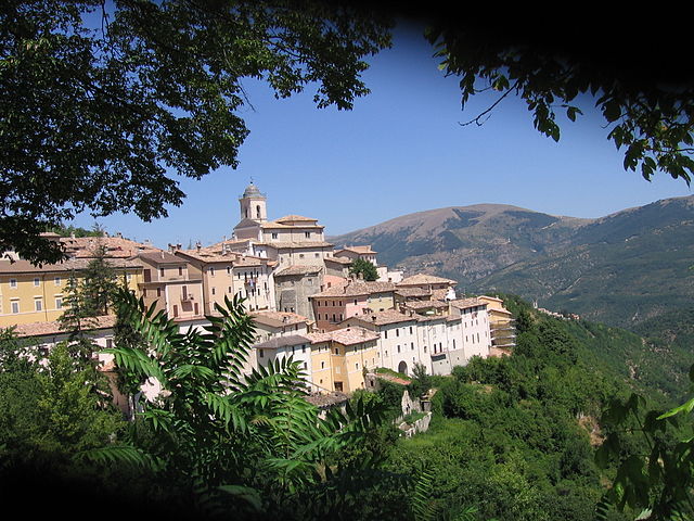
- коммуна Италии
Hiking in Черрето-ди-Сполето
Cerreto di Spoleto is a charming village located in the Umbria region of Italy, nestled among the Apennine Mountains. This area is known for its stunning natural beauty, rich history, and well-maintained hiking trails, making it a great destination for outdoor enthusiasts....
- Страна:
- Почтовый код: 06040
- Телефонный код: 0743
- Код автомобильного номера: PG
- Координаты: 42° 49' 0" N, 12° 55' 0" E
- GPS треки (wikiloc): [Ссылка]
- Высота над уровнем моря: 557 м m
- Площадь: 74.78 кв.км
- Население: 1055
- Веб сайт: [Ссылка]

Фолиньо
- коммуна Италии
Hiking in Фолиньо
Foligno, located in the heart of Italy's Umbria region, offers a beautiful landscape perfect for hiking enthusiasts. The area is characterized by rolling hills, picturesque valleys, and a rich tapestry of nature that includes forests, fields, and scenic views....
- Страна:
- Почтовый код: 06034
- Телефонный код: 0742
- Код автомобильного номера: PG
- Координаты: 42° 57' 22" N, 12° 42' 12" E
- GPS треки (wikiloc): [Ссылка]
- Высота над уровнем моря: 234 м m
- Площадь: 264.67 кв.км
- Население: 57059
- Веб сайт: [Ссылка]

Пречи
- коммуна Италии
Hiking in Пречи
Preci, located in the beautiful region of Umbria in Italy, is an excellent destination for hiking enthusiasts. The area is characterized by its stunning landscapes, including rolling hills, lush forests, and picturesque views of the surrounding valleys. Here are some highlights about hiking in Preci:...
- Страна:
- Почтовый код: 06047
- Телефонный код: 0743
- Код автомобильного номера: PG
- Координаты: 42° 53' 0" N, 13° 2' 0" E
- GPS треки (wikiloc): [Ссылка]
- Высота над уровнем моря: 596 м m
- Площадь: 82.03 кв.км
- Население: 704
- Веб сайт: [Ссылка]


Селлано
- коммуна Италии
Hiking in Селлано
Sellano, a picturesque village located in the heart of the Umbria region of Italy, offers a variety of hiking opportunities set against a backdrop of stunning landscapes, rolling hills, and rich cultural heritage. Here are some highlights of hiking in Sellano:...
- Страна:
- Почтовый код: 06030
- Телефонный код: 0743
- Код автомобильного номера: PG
- Координаты: 42° 53' 14" N, 12° 55' 23" E
- GPS треки (wikiloc): [Ссылка]
- Высота над уровнем моря: 640 м m
- Площадь: 85.85 кв.км
- Население: 1048
- Веб сайт: [Ссылка]
Кастельсантанджело-суль-Нера
- коммуна Италии
Hiking in Кастельсантанджело-суль-Нера
Castelsantangelo sul Nera is a beautiful commune located in the Marche region of Italy, surrounded by stunning natural landscapes that are perfect for hiking enthusiasts. Nestled within the Sibillini Mountains National Park, it offers a variety of trails with diverse levels of difficulty, catering to both beginners and experienced hikers....
- Страна:
- Почтовый код: 62030
- Телефонный код: 0737
- Код автомобильного номера: MC
- Координаты: 42° 53' 41" N, 13° 9' 12" E
- GPS треки (wikiloc): [Ссылка]
- Высота над уровнем моря: 760 м m
- Площадь: 70.67 кв.км
- Население: 260
- Веб сайт: [Ссылка]
Монте-Кавалло
- коммуна Италии
Hiking in Монте-Кавалло
Monte Cavallo, or "Hochfügen" as it’s sometimes referred to, is a stunning mountain in the Tyrolean Alps, located in northern Italy near the border with Austria. The area is renowned for its breathtaking views, diverse hiking trails, and vibrant alpine flora....
- Страна:
- Почтовый код: 62030
- Телефонный код: 0737
- Код автомобильного номера: MC
- Координаты: 43° 0' 25" N, 13° 0' 19" E
- GPS треки (wikiloc): [Ссылка]
- Высота над уровнем моря: 648 м m
- Площадь: 38.51 кв.км
- Население: 129
- Веб сайт: [Ссылка]
Пьеве-Торина
- коммуна Италии
Hiking in Пьеве-Торина
Pieve Torina is a beautiful village located in the Marche region of Italy, known for its picturesque landscapes and charming medieval architecture. The area offers various hiking opportunities that allow enthusiasts to explore the stunning Apennine Mountains and the surrounding countryside....
- Страна:
- Почтовый код: 62036
- Телефонный код: 0737
- Код автомобильного номера: MC
- Координаты: 43° 2' 40" N, 13° 3' 1" E
- GPS треки (wikiloc): [Ссылка]
- Высота над уровнем моря: 470 м m
- Площадь: 74.8 кв.км
- Население: 1389
- Веб сайт: [Ссылка]
Серравалле-ди-Кьенти
- коммуна Италии
Hiking in Серравалле-ди-Кьенти
Serravalle di Chienti is a picturesque town located in the Marche region of Italy, surrounded by stunning landscapes that are perfect for hiking enthusiasts. The area is known for its diverse terrain, featuring hills, valleys, and forests, making it an ideal destination for both beginner and experienced hikers....
- Страна:
- Почтовый код: 62038
- Телефонный код: 0737
- Код автомобильного номера: MC
- Координаты: 43° 4' 20" N, 12° 57' 7" E
- GPS треки (wikiloc): [Ссылка]
- Высота над уровнем моря: 667 м m
- Площадь: 95.99 кв.км
- Население: 1056
- Веб сайт: [Ссылка]


Уссита
- коммуна Италии
Hiking in Уссита
Ussita, located in the Marche region of Italy, is a picturesque destination known for its stunning natural scenery and hiking opportunities. Nestled within the Sibillini Mountains National Park, Ussita offers a mix of challenging trails and scenic routes, making it an excellent spot for both novice and experienced hikers....
- Страна:
- Почтовый код: 62039
- Телефонный код: 0737
- Код автомобильного номера: MC
- Координаты: 42° 56' 20" N, 13° 8' 52" E
- GPS треки (wikiloc): [Ссылка]
- Высота над уровнем моря: 744 м m
- Площадь: 55.3 кв.км
- Население: 419
- Веб сайт: [Ссылка]