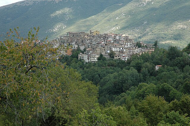
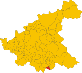
Виваро-Романо (Vivaro Romano, Vivaro Romano)
.svg)
- коммуна Италии
 Hiking in Виваро-Романо
Vivaro Romano is a charming town located in the province of Rome, Italy, surrounded by stunning landscapes and natural beauty, making it a fantastic destination for hiking enthusiasts.
Trail Options:
-
Sentiero degli Antichi Fossi: This trail offers a glimpse into the local flora and fauna, along with beautiful views of the surrounding valleys. It is moderately challenging and suitable for most hikers.
-
Path to Monte Gennaro: For those looking for a more strenuous hike, the route leading to Monte Gennaro provides breathtaking panoramic views over the surrounding countryside. The trail can be steep in places but rewards hikers with stunning vistas.
-
Canalone di Vivaro: This is a beautiful nature trail that winds through the forest, characterized by its diverse plant species and the soothing sounds of local wildlife. It's ideal for leisurely hikes and nature walks.
Best Time to Hike:
The best time for hiking in Vivaro Romano is during the spring (April to June) and autumn (September to October) when the weather is typically mild, and the landscapes are alive with color. Summers can be hot, while winters may bring colder temperatures and potential snowfall, which can affect trail accessibility.
Equipment and Preparation:
- Footwear: Sturdy hiking boots are essential, as some trails may be rocky or uneven.
- Clothing: Dress in layers to adapt to changing weather conditions. A lightweight rain jacket is advisable.
- Supplies: Carry plenty of water, snacks, and a first-aid kit. A map or GPS device is also recommended for navigation.
Local Attractions:
When taking a break from hiking, visitors can explore the town of Vivaro Romano itself, with its historic architecture and quaint streets. Additionally, the nearby Natural Park of Simbruini offers expansive opportunities for hiking and nature exploration.
Conclusion:
Hiking in Vivaro Romano provides a wonderful experience for nature lovers, with trails suitable for various skill levels and the chance to enjoy Italy's beautiful countryside. Make sure to respect the natural environment and follow local guidelines while trekking!
- Страна:

- Почтовый код: 00020
- Телефонный код: 0774
- Код автомобильного номера: RM
- Координаты: 42° 6' 2" N, 13° 0' 27" E


- GPS треки (wikiloc): [Ссылка]
- Высота над уровнем моря: 756 м m
- Площадь: 12.54 кв.км
- Население: 158
- Веб сайт: http://www.comunedivivaroromano.it
- Википедия русская: wiki(ru)
- Википедия английская: wiki(en)
- Википедия национальная: wiki(it)
- Хранилище Wikidata: Wikidata: Q243525
- Катеория в википедии: [Ссылка]
- код Freebase: [/m/0gm8nw]
- код GeoNames: Альт: [6541891]
- код VIAF: Альт: [259199479]
- ID отношения в OpenStreetMap: [41775]
- код ISTAT: 058113
- кадастровый код Италии: M095
Граничит с регионами:


Орвинио
- коммуна Италии
Hiking in Орвинио
Orvinio is a charming town located in the Sabina region of Italy, known for its stunning landscapes, ancient history, and rich cultural heritage. Hiking in and around Orvinio offers a range of experiences for outdoor enthusiasts. Here are some highlights:...
- Страна:
- Почтовый код: 02035
- Телефонный код: 0765
- Код автомобильного номера: RI
- Координаты: 42° 8' 0" N, 12° 56' 0" E
- GPS треки (wikiloc): [Ссылка]
- Высота над уровнем моря: 840 м m
- Площадь: 24.69 кв.км
- Население: 387
- Веб сайт: [Ссылка]


Поццалья-Сабина
- коммуна Италии
Hiking in Поццалья-Сабина
Pozzaglia Sabina is a picturesque village located in the Sabina region of Italy, known for its beautiful natural landscapes, rolling hills, and rich history. The area is perfect for hiking enthusiasts due to its varied terrain and scenic views. Here are some key points to consider for hiking in Pozzaglia Sabina:...
- Страна:
- Почтовый код: 02030
- Телефонный код: 0765
- Код автомобильного номера: RI
- Координаты: 42° 10' 0" N, 12° 58' 0" E
- GPS треки (wikiloc): [Ссылка]
- Высота над уровнем моря: 878 м m
- Площадь: 24.98 кв.км
- Население: 331
- Веб сайт: [Ссылка]
Турания
- коммуна Италии
Hiking in Турания
Turania, known for its stunning landscapes and rich biodiversity, offers an array of hiking opportunities for outdoor enthusiasts. While it's not one of the most famous hiking destinations, it can provide a unique experience, especially for those looking to explore natural beauty away from the typical trails....
- Страна:
- Почтовый код: 02020
- Телефонный код: 0765
- Код автомобильного номера: RI
- Координаты: 42° 8' 0" N, 13° 1' 0" E
- GPS треки (wikiloc): [Ссылка]
- Высота над уровнем моря: 703 м m
- Площадь: 8.51 кв.км
- Население: 238
- Веб сайт: [Ссылка]
Риофреддо
- коммуна Италии
Hiking in Риофреддо
Riofreddo is a picturesque village located in the province of Rome, Italy, surrounded by the stunning landscapes of the Apennine Mountains. It's a great destination for hiking enthusiasts, offering various trails that cater to different skill levels. Here are some highlights for hiking in the Riofreddo area:...
- Страна:
- Почтовый код: 00020
- Телефонный код: 0774
- Код автомобильного номера: ROMA
- Координаты: 42° 3' 32" N, 12° 59' 48" E
- GPS треки (wikiloc): [Ссылка]
- Высота над уровнем моря: 705 м m
- Площадь: 12.38 кв.км
- Население: 749
- Веб сайт: [Ссылка]
Валлинфреда
- коммуна Италии
Hiking in Валлинфреда
Vallinfreda is a picturesque village located in the Lazio region of Italy, nestled in the Monti Simbruini National Park. This area is known for its beautiful landscapes, rich biodiversity, and a variety of hiking trails suitable for different skill levels. Here are some key points about hiking in Vallinfreda:...
- Страна:
- Почтовый код: 00020
- Телефонный код: 0774
- Код автомобильного номера: RM
- Координаты: 42° 5' 0" N, 12° 58' 0" E
- GPS треки (wikiloc): [Ссылка]
- Высота над уровнем моря: 870 м m
- Площадь: 16.72 кв.км
- Население: 291
- Веб сайт: [Ссылка]


Карсоли
- коммуна в Италии
Hiking in Карсоли
Carsoli, located in the Abruzzo region of Italy, offers some beautiful hiking opportunities amidst its picturesque landscapes, rich history, and diverse flora and fauna. Here are some highlights and tips for hiking in and around Carsoli:...
- Страна:
- Почтовый код: 67061
- Телефонный код: 0863
- Код автомобильного номера: AQ
- Координаты: 42° 5' 56" N, 13° 5' 19" E
- GPS треки (wikiloc): [Ссылка]
- Высота над уровнем моря: 616 м m
- Площадь: 95.8 кв.км
- Население: 5314
- Веб сайт: [Ссылка]


Орикола
- коммуна Италии
Hiking in Орикола
Oricola is a charming town located in the province of L'Aquila, in the Abruzzo region of Italy. It is known for its stunning natural landscapes, making it an excellent destination for hiking enthusiasts. Here are some key points to consider when hiking in Oricola:...
- Страна:
- Почтовый код: 67063
- Телефонный код: 0863
- Код автомобильного номера: AQ
- Координаты: 42° 3' 1" N, 13° 2' 22" E
- GPS треки (wikiloc): [Ссылка]
- Высота над уровнем моря: 810 м m
- Площадь: 18.36 кв.км
- Население: 1251
- Веб сайт: [Ссылка]