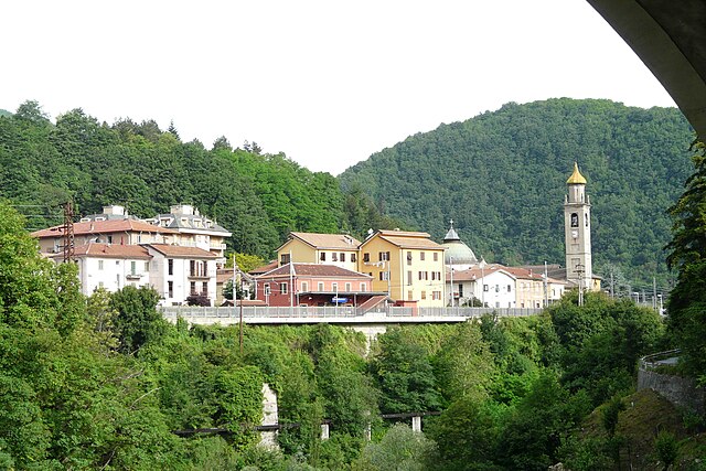
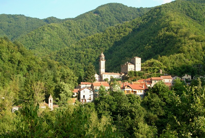
Воббия (Vobbia, Vobbia)
.svg)
- коммуна Италии
 Hiking in Воббия
Vobbia is a charming municipality in the Liguria region of Italy, nestled in the Apennine Mountains. Its picturesque landscapes and rich natural surroundings make it an excellent destination for hiking enthusiasts. Here’s a breakdown of what you can expect when hiking in Vobbia:
Trails and Routes
-
Variety of Trails: Vobbia offers a range of hiking trails that cater to different skill levels, from easy walks to more challenging hikes. Many routes provide stunning views of the surrounding mountains, valleys, and forests.
-
Nature Paths: The area is home to numerous natural paths that meander through lush woodlands and along waterways. Be sure to look out for local flora and fauna along the way.
-
Historical Trails: Some trails may lead you to ancient ruins, churches, and old pathways rich in history, giving you a glimpse into the past of the region.
Scenery and Flora
- Breathtaking Landscapes: The scenic beauty of Vobbia includes rolling hills, dense forests, and clear streams. Various viewpoints along the trails provide breathtaking vistas of the Apennines.
- Flora and Fauna: The region is rich in biodiversity, so keep an eye out for local wildlife and unique plants, especially during the spring and summer months.
Tips for Hiking in Vobbia
- Season Considerations: While spring and fall are ideal for hiking due to mild temperatures, summer can get quite hot. Winter hiking is also an option but requires proper gear and awareness of weather conditions.
- Gear Up: Make sure to wear sturdy hiking boots and bring sufficient water, snacks, and a map or GPS device to stay on track.
- Local Guides: Consider hiring a local guide or joining a hiking group to make the most of your experience, as they can provide insights and ensure you explore safely.
Accessibility
- Vobbia is accessible by car, and its proximity to other towns makes it easy to combine your hiking adventures with cultural experiences in the Ligurian region.
Conclusion
Hiking in Vobbia is an excellent way to experience the natural beauty and tranquility of the Liguria region. Whether you're looking for a short hike or a full-day adventure, you’ll find a range of options that can lead to both physical challenge and serene moments in nature. Always prioritize safety and leave no trace to help preserve the area for future hikers. Enjoy your adventure!
- Страна:

- Почтовый код: 16010
- Телефонный код: 010
- Код автомобильного номера: GE
- Координаты: 44° 35' 58" N, 9° 2' 24" E


- GPS треки (wikiloc): [Ссылка]
- Высота над уровнем моря: 477 м m
- Площадь: 33.43 кв.км
- Население: 398
- Веб сайт: http://www.comune.vobbia.ge.it/
- Википедия русская: wiki(ru)
- Википедия английская: wiki(en)
- Википедия национальная: wiki(it)
- Хранилище Wikidata: Wikidata: Q266145
- Катеория в википедии: [Ссылка]
- код Freebase: [/m/0ghx1v]
- код GeoNames: Альт: [6537066]
- ID отношения в OpenStreetMap: [43337]
- место в MusicBrainz: [6ed9b3f9-5657-47a0-95a5-a7c6da2cdf37]
- код ISTAT: 010066
- кадастровый код Италии: M105
Граничит с регионами:

Каррега-Лигуре
- коммуна в регионе Пьемонт, Италия
Hiking in Каррега-Лигуре
Carrega Ligure is a beautiful destination for hiking enthusiasts, located in the picturesque region of Liguria, Italy. Nestled in the Apennine Mountains, it offers stunning landscapes characterized by lush forests, rolling hills, and scenic views....
- Страна:
- Почтовый код: 15060
- Телефонный код: 0143
- Код автомобильного номера: AL
- Координаты: 44° 37' 15" N, 9° 10' 33" E
- GPS треки (wikiloc): [Ссылка]
- Высота над уровнем моря: 958 м m
- Площадь: 55.26 кв.км
- Население: 86
- Веб сайт: [Ссылка]

Монджардино-Лигуре
- коммуна в регионе Пьемонт, Италия
Hiking in Монджардино-Лигуре
Mongiardino Ligure, a charming village located in the Piedmont region of Italy, is nestled in the Apennine Mountains and offers a variety of hiking opportunities. Here are some highlights for hikers interested in exploring this beautiful area:...
- Страна:
- Почтовый код: 15060
- Телефонный код: 0143
- Код автомобильного номера: AL
- Координаты: 44° 38' 24" N, 9° 3' 42" E
- GPS треки (wikiloc): [Ссылка]
- Высота над уровнем моря: 600 м m
- Площадь: 29.03 кв.км
- Население: 159
- Веб сайт: [Ссылка]


Бузалла
- коммуна Италии
Hiking in Бузалла
Busalla is a charming town in the province of Genoa, Italy, surrounded by beautiful landscapes that offer a range of hiking opportunities. The area is characterized by its lush greenery, rolling hills, and stunning views of the surrounding Apennines. Here’s what you need to know about hiking in and around Busalla:...
- Страна:
- Почтовый код: 16012
- Телефонный код: 010
- Код автомобильного номера: GE
- Координаты: 44° 34' 16" N, 8° 56' 43" E
- GPS треки (wikiloc): [Ссылка]
- Высота над уровнем моря: 358 м m
- Площадь: 17.06 кв.км
- Население: 5545
- Веб сайт: [Ссылка]


Крочефиески
- коммуна Италии
Hiking in Крочефиески
Crocefieschi is a small town located in the Liguria region of Italy, nestled in the Apennine Mountains. This area can be a delightful destination for those looking to experience hiking amidst picturesque landscapes, rich biodiversity, and charming villages. Here are some key aspects to consider if you're planning to hike in Crocefieschi:...
- Страна:
- Почтовый код: 16010
- Телефонный код: 010
- Код автомобильного номера: GE
- Координаты: 44° 35' 5" N, 9° 1' 24" E
- GPS треки (wikiloc): [Ссылка]
- Высота над уровнем моря: 742 м m
- Площадь: 11.73 кв.км
- Население: 541
- Веб сайт: [Ссылка]

Изола-дель-Кантоне
- коммуна Италии
Hiking in Изола-дель-Кантоне
Isola del Cantone is a charming municipality located in the Liguria region of Italy, nestled in the Apennine Mountains. Known for its stunning natural landscapes, it offers a variety of hiking opportunities, making it a fantastic destination for both beginners and experienced hikers....
- Страна:
- Почтовый код: 16017
- Телефонный код: 010
- Код автомобильного номера: GE
- Координаты: 44° 38' 46" N, 8° 57' 25" E
- GPS треки (wikiloc): [Ссылка]
- Высота над уровнем моря: 296 м m
- Площадь: 47.97 кв.км
- Население: 1488
- Веб сайт: [Ссылка]

Вальбревенна
- коммуна Италии
Hiking in Вальбревенна
Valbrevenna is a beautiful valley located in the Liguria region of Italy, known for its picturesque landscapes, historical villages, and scenic hiking trails. The area is less commercialized than some other parts of Liguria, making it ideal for those seeking a more tranquil hiking experience....
- Страна:
- Почтовый код: 16010
- Телефонный код: 010
- Код автомобильного номера: GE
- Координаты: 44° 33' 58" N, 9° 3' 48" E
- GPS треки (wikiloc): [Ссылка]
- Высота над уровнем моря: 533 м m
- Площадь: 34.67 кв.км
- Население: 788
- Веб сайт: [Ссылка]