
Веймар (Weimar, Weimar)

- город в земле Тюрингия, Германия
 Hiking in Веймар
Weimar, located in the heart of Germany, is not only famous for its rich cultural history but also offers some beautiful walking and hiking opportunities. Here are some highlights and suggestions for hiking in and around Weimar:
1.
- Distance: Various trails of different lengths
- Description: This large park offers a network of paths suitable for leisurely walks or more vigorous hikes. It features beautiful landscapes, historic buildings, and the Ilm River, providing a scenic and tranquil environment.
2.
- Distance: Approximately 10 km round trip
- Description: Just northwest of Weimar, Ettersberg is a popular hiking destination. You can hike up to the Buchenwald Memorial, which is a significant historical site. The ascent offers great views over the surrounding areas.
3.
- Distance: Varies (with extensive trails available)
- Description: A bit further from Weimar, the Thuringian Forest is a fantastic destination for nature lovers and hikers. There are numerous trails, including parts of the famous Rennsteig trail, which is one of Germany’s oldest long-distance trails.
4.
- Distance: Approximately 30 km
- Description: This scenic trail connects Weimar and Jena and can be enjoyed by both hikers and cyclists. It takes you through lush landscapes, forests, and vineyards.
5.
- Description: Around Weimar, there are several marked nature trails that allow you to explore local flora and fauna. These trails vary in difficulty and are suitable for hikers of all skill levels.
Tips for Hiking in Weimar:
- Preparation: Always check the weather conditions before heading out and dress appropriately. Bring plenty of water and snacks.
- Maps and Guides: It’s helpful to carry a map of the trails or a hiking app on your phone for navigation.
- Respect Nature: Follow local guidelines to protect the environment. Stay on designated paths to minimize impact.
Whether you’re interested in a short hike or a more challenging adventure, Weimar offers a good variety of options to enjoy the beautiful Thuringian landscape. Happy hiking!
- Страна:

- Почтовый код: 99427; 99425; 99423
- Телефонный код: 036453; 03643
- Код автомобильного номера: WE
- Координаты: 50° 59' 0" N, 11° 19' 0" E


- GPS треки (wikiloc): [Ссылка]
- Высота над уровнем моря: 208 м m
- Площадь: 84.48 кв.км
- Население: 64131
- Веб сайт: https://www.weimar.de/
- Википедия русская: wiki(ru)
- Википедия английская: wiki(en)
- Википедия национальная: wiki(de)
- Хранилище Wikidata: Wikidata: Q3955
- Галерея изображений в википедии: [Ссылка]
- Катеория в википедии: [Ссылка]
- Карты в википедии: [Ссылка]
- код Freebase: [/m/0cpyv]
- код GeoNames: Альт: [2812482]
- код VIAF: Альт: [136822898]
- ID отношения в OpenStreetMap: [62493]
- код GND: Альт: [4065105-8]
- идентификатор местоположения ArchINFORM: [490]
- код LCNAF: Альт: [n81042181]
- код тезауруса PACTOLS: [pcrtaOtBgcMNsz]
- место в MusicBrainz: [c7644e45-dec4-43fd-aad6-35036b8e911d]
- код темы Quora: [Weimar-Germany]
- код в Большой каталанской энциклопедии: [0071957]
- код в Encyclopædia Universalis: [weimar]
- EMLO location ID: [5e2f7157-ce49-4268-9252-0551ad15f879]
- код места в Facebook: [107866695913587]
- код в Большой российской энциклопедии онлайн: [1903859]
- код NKC: [ge131393]
- dmoz: Альт: [Regional/Europe/Germany/States/Thuringia/Localities/Weimar/]
- код NLI: [000984617]
- код NUTS: [DEG05]
- идентификатор муниципалитетов в Германии: 16055000
- код US National Archives: 10037931
- код района Германии: 16055
Включает регионы:
Niedergrunstedt
Hiking in Niedergrunstedt
Niedergrunstedt is a small village located in Germany, and while it may not be widely known for hiking, there are often lovely trails in rural areas that can provide a tranquil hiking experience. Here are a few points to consider if you're thinking about hiking in and around Niedergrunstedt:...
- Страна:
- Почтовый код: 99428
- Телефонный код: 03643
- Координаты: 50° 57' 27" N, 11° 17' 1" E
- GPS треки (wikiloc): [Ссылка]
- Высота над уровнем моря: 304 м m

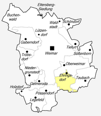
Ehringsdorf
Hiking in Ehringsdorf
Ehringsdorf is a picturesque village located in the Thuringia region of Germany, near the city of Jena. It's an excellent spot for hiking enthusiasts given its stunning natural landscapes, diverse trails, and proximity to the picturesque Saale Valley....
- Страна:
- Почтовый код: 99425
- Телефонный код: 03643
- Координаты: 50° 57' 33" N, 11° 20' 50" E
- GPS треки (wikiloc): [Ссылка]
- Высота над уровнем моря: 220 м m
Tröbsdorf
Hiking in Tröbsdorf
Tröbsdorf, located near Weimar in Germany, offers a lovely setting for hiking enthusiasts. The region is characterized by its beautiful landscapes, lush greenery, and rolling hills, providing a perfect backdrop for a day of hiking....
- Страна:
- Почтовый код: 99428
- Телефонный код: 03643
- Координаты: 50° 59' 1" N, 11° 16' 50" E
- GPS треки (wikiloc): [Ссылка]
- Высота над уровнем моря: 255 м m
Обервеймар
- район Веймара
Hiking in Обервеймар
Oberweimar, located in the state of Thüringen (Thuringia), Germany, is a region known for its beautiful landscapes, historical significance, and a variety of outdoor activities, including hiking. Here are some key points to consider when hiking in this area:...
- Страна:
- Почтовый код: 99425
- Телефонный код: 03643
- Координаты: 50° 57' 56" N, 11° 20' 42" E
- GPS треки (wikiloc): [Ссылка]
- Высота над уровнем моря: 215 м m
Gelmeroda
Hiking in Gelmeroda
Gelmeroda is a small village located in Germany, known for its scenic landscapes. While it's not a widely recognized hiking destination, there are opportunities to enjoy nature in and around the area. Here are some tips and highlights for hiking near Gelmeroda:...
- Страна:
- Почтовый код: 99428
- Телефонный код: 03643
- Координаты: 50° 56' 55" N, 11° 18' 5" E
- GPS треки (wikiloc): [Ссылка]
- Высота над уровнем моря: 340 м m
Gaberndorf
Hiking in Gaberndorf
Gaberndorf, a small village located in Styria, Austria, offers various opportunities for hiking enthusiasts. While it may not be as famous as more prominent hiking regions in Austria, it is surrounded by beautiful landscapes and often provides a more tranquil experience in nature....
- Страна:
- Почтовый код: 99428
- Телефонный код: 03643
- Координаты: 50° 59' 44" N, 11° 16' 34" E
- GPS треки (wikiloc): [Ссылка]
- Высота над уровнем моря: 274 м m


Legefeld
Hiking in Legefeld
Legefeld, a village located in the district of Weimarer Land in Thuringia, Germany, is surrounded by beautiful natural landscapes that offer various hiking opportunities. While it may not be as well-known as larger hiking destinations, it serves as a great base for exploring the scenic Thuringian countryside....
- Страна:
- Почтовый код: 99428
- Телефонный код: 03643
- Координаты: 50° 56' 2" N, 11° 17' 35" E
- GPS треки (wikiloc): [Ссылка]
- Высота над уровнем моря: 339 м m
- Площадь: 5.5 кв.км


Поссендорф
- район Веймара
Hiking in Поссендорф
Possendorf is a small village located near Weimar in Thuringia, Germany, known for its picturesque landscapes and proximity to various hiking trails. While the village itself may not have extensive hiking routes, it serves as a great starting point for exploring the surrounding areas, which are rich in natural beauty and cultural history....
- Страна:
- Почтовый код: 99428
- Телефонный код: 03643
- Координаты: 50° 56' 26" N, 11° 18' 45" E
- GPS треки (wikiloc): [Ссылка]
- Высота над уровнем моря: 337 м m


Шёндорф
- район Веймара
Hiking in Шёндорф
Schöndorf, a district of Weimar in Germany, is surrounded by beautiful landscapes that offer a variety of hiking opportunities. While Schöndorf itself may not have extensive hiking trails, the nearby Thuringian Forest and the scenic surroundings of Weimar provide ample options for hikers of all skill levels....
- Страна:
- Почтовый код: 99427
- Телефонный код: 03643
- Координаты: 51° 0' 54" N, 11° 21' 14" E
- GPS треки (wikiloc): [Ссылка]
- Высота над уровнем моря: 315 м m
Süßenborn
Hiking in Süßenborn
Süßenborn, a picturesque village in Germany, is often appreciated for its natural landscapes and opportunities for outdoor activities, particularly hiking. Here are some key points to consider if you're planning a hike in the area:...
- Страна:
- Почтовый код: 99425
- Телефонный код: 03643
- Координаты: 50° 59' 1" N, 11° 23' 25" E
- GPS треки (wikiloc): [Ссылка]
- Высота над уровнем моря: 239 м m
Taubach (Weimar)
Hiking in Taubach (Weimar)
Taubach, a district of Weimar in Germany, is surrounded by picturesque landscapes, making it an appealing destination for hiking enthusiasts. The area boasts beautiful natural scenery, with woodlands, hills, and open fields that provide a peaceful backdrop for outdoor activities....
- Страна:
- Почтовый код: 99425
- Телефонный код: 036453
- Координаты: 50° 57' 3" N, 11° 22' 56" E
- GPS треки (wikiloc): [Ссылка]
- Высота над уровнем моря: 235 м m


Тифурт
- район Веймара
Hiking in Тифурт
Tiefurt, a small village located in the German state of Thuringia, offers a lovely setting for hiking, especially within the surrounding landscapes of the Thuringian Forest. Here are a few highlights to consider when planning a hike in and around Tiefurt:...
- Страна:
- Почтовый код: 99425
- Телефонный код: 03643
- Координаты: 50° 59' 27" N, 11° 20' 51" E
- GPS треки (wikiloc): [Ссылка]
- Высота над уровнем моря: 202 м m
Граничит с регионами:
Ваймарер-Ланд
- район земли Тюрингия, Германия
Hiking in Ваймарер-Ланд
Weimarer Land, located in the state of Thuringia, Germany, is a picturesque region that offers a diverse range of hiking opportunities. The area is steeped in history and culture, with connections to famous figures like Goethe and Schiller who spent significant time in nearby Weimar. Here’s what you can expect when hiking in Weimarer Land:...
- Страна:
- Код автомобильного номера: APD; AP
- Координаты: 51° 0' 0" N, 11° 25' 12" E
- GPS треки (wikiloc): [Ссылка]
- Высота над уровнем моря: 263 м m
- Площадь: 804.48 кв.км
- Население: 82127
- Веб сайт: [Ссылка]