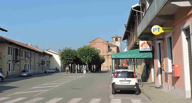
Цубьена (Zubiena, Zubiena)
- коммуна Италии
 Hiking in Цубьена
Zubiena, located in the province of Biella in the Piedmont region of northern Italy, offers beautiful hiking opportunities amidst scenic landscapes. The area is characterized by its rolling hills, lush forests, and picturesque views of the surrounding mountains, making it an ideal destination for nature enthusiasts and outdoor adventurers.
Hiking Trails
-
Local Trails: There are numerous trails that weave through Zubiena and the surrounding region. Many of these are well-marked and vary in difficulty, catering to both beginners and experienced hikers.
-
Nature Reserves: Explore nearby nature reserves, which often have established hiking paths. These routes allow hikers to experience the local flora and fauna, making for a rewarding outdoor experience.
-
Cultural Pathways: Some trails in Zubiena might lead you through historical sites or cultural landmarks, giving you insight into the local history and traditions.
Preparation Tips
- Equipment: Ensure you have proper hiking boots, a backpack, water, snacks, and a first-aid kit. Depending on the season, consider weather-appropriate clothing.
- Navigation: Use a physical map or a GPS device; while the trails may be marked, it’s good to have a way to navigate.
- Safety: Always inform someone of your hiking plans and the anticipated duration of your hike.
Best Times to Hike
- Spring and Fall: These seasons are ideal due to mild temperatures and beautiful scenery. Spring showcases blooming flora, while fall offers stunning foliage.
- Summer: Be prepared for warmer weather and potential crowds on popular trails.
- Winter: If you're interested in winter hiking, check for snow conditions and appropriate gear.
Local Attractions
- Culinary Experiences: After your hike, enjoy local cuisine in Zubiena. The region is known for its delicious traditional dishes.
- Cultural Sites: Visit historical churches and local art that may be found along your hiking routes.
Conclusion
Hiking in Zubiena can be an exceptional experience due to the natural beauty and cultural richness of the area. Ensure you prepare adequately and take the time to enjoy the breathtaking landscapes and peaceful surroundings.
- Страна:

- Почтовый код: 13888
- Телефонный код: 015
- Код автомобильного номера: BI
- Координаты: 45° 29' 0" N, 7° 57' 0" E


- GPS треки (wikiloc): [Ссылка]
- Высота над уровнем моря: 429 м m
- Площадь: 12.47 кв.км
- Население: 1180
- Веб сайт: http://www.comunezubiena.it
- Википедия русская: wiki(ru)
- Википедия английская: wiki(en)
- Википедия национальная: wiki(it)
- Хранилище Wikidata: Wikidata: Q18197
- Катеория в википедии: [Ссылка]
- код Freebase: [/m/0gr31s]
- код GeoNames: Альт: [6543664]
- ID отношения в OpenStreetMap: [45091]
- код ISTAT: 096082
- кадастровый код Италии: M196
Граничит с регионами:
Борриана
- коммуна Италии
Hiking in Борриана
Borriana is a charming town in the province of Biella, located in the Piedmont region of Northern Italy. The area around Borriana offers a variety of hiking opportunities that cater to different skill levels and interests, making it a wonderful destination for outdoor enthusiasts....
- Страна:
- Почтовый код: 13872
- Телефонный код: 015
- Код автомобильного номера: BI
- Координаты: 45° 30' 0" N, 8° 2' 0" E
- GPS треки (wikiloc): [Ссылка]
- Высота над уровнем моря: 350 м m
- Площадь: 5.35 кв.км
- Население: 889
- Веб сайт: [Ссылка]

Черрионе
- коммуна Италии
Hiking in Черрионе
Cerrione is a small town in the Piedmont region of Italy, located near the larger city of Biella. While it may not be a well-known hiking destination compared to other areas in Italy, the surrounding landscape offers potential for pleasant hikes, particularly for those who enjoy exploring nature, forests, and rural scenery....
- Страна:
- Почтовый код: 13882
- Телефонный код: 015
- Код автомобильного номера: BI
- Координаты: 45° 28' 0" N, 8° 4' 0" E
- GPS треки (wikiloc): [Ссылка]
- Высота над уровнем моря: 250 м m
- Площадь: 27.99 кв.км
- Население: 2894
- Веб сайт: [Ссылка]

Маньяно
- коммуна Италии
Hiking in Маньяно
Magnano, located in the province of Biella in northern Italy, offers a beautiful setting for hiking enthusiasts. This area is known for its stunning landscapes, rolling hills, and rich natural biodiversity, making it an excellent destination for outdoor activities....
- Страна:
- Почтовый код: 13887
- Телефонный код: 015
- Код автомобильного номера: BI
- Координаты: 45° 27' 48" N, 8° 0' 11" E
- GPS треки (wikiloc): [Ссылка]
- Высота над уровнем моря: 543 м m
- Площадь: 10.56 кв.км
- Население: 398
- Веб сайт: [Ссылка]

Монграндо
- коммуна Италии
Hiking in Монграндо
Mongrando is a small town in the Piedmont region of Italy, situated near the foothills of the Alps. While it may not be as widely known as some other hiking destinations, it offers beautiful landscapes and opportunities for outdoor activities, including hiking. Here are some details about hiking in and around Mongrando:...
- Страна:
- Почтовый код: 13888
- Телефонный код: 015
- Код автомобильного номера: BI
- Координаты: 45° 31' 0" N, 8° 0' 0" E
- GPS треки (wikiloc): [Ссылка]
- Высота над уровнем моря: 355 м m
- Площадь: 16.5 кв.км
- Население: 3800
- Веб сайт: [Ссылка]
Сала-Бьеллезе
- коммуна Италии
Hiking in Сала-Бьеллезе
Sala Biellese is a charming village located in the Piedmont region of Italy, surrounded by beautiful landscapes that make it an attractive destination for hikers. The area offers various trails that cater to different skill levels, allowing both experienced hikers and novices to enjoy the natural beauty of the region....
- Страна:
- Почтовый код: 13884
- Телефонный код: 015
- Код автомобильного номера: BI
- Координаты: 45° 30' 0" N, 7° 57' 0" E
- GPS треки (wikiloc): [Ссылка]
- Высота над уровнем моря: 626 м m
- Площадь: 8.03 кв.км
- Население: 577
- Веб сайт: [Ссылка]
Торраццо
- коммуна Италии
Hiking in Торраццо
Torrazzo, located in Italy, is best known for its historic bell tower in the city of Cremona rather than for hiking specifically. However, if you're asking about the general hiking opportunities in the surrounding Lombardy region, there are many beautiful trails and natural areas worth exploring....
- Страна:
- Почтовый код: 13884
- Телефонный код: 015
- Код автомобильного номера: BI
- Координаты: 45° 29' 55" N, 7° 57' 15" E
- GPS треки (wikiloc): [Ссылка]
- Высота над уровнем моря: 622 м m
- Площадь: 5.77 кв.км
- Население: 212
- Веб сайт: [Ссылка]