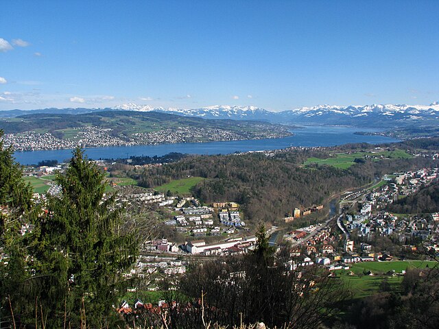
Адлисвиль (Adliswil, Adliswil)

 Hiking in Адлисвиль
Adliswil, located just south of Zurich in Switzerland, offers a variety of hiking opportunities that showcase the beautiful landscapes of the Zurich region. Here are some highlights and tips for hiking in Adliswil:
Hiking Trails
-
Uetliberg Mountain: A popular destination accessible from Adliswil, the Uetliberg offers panoramic views of Zurich and Lake Zurich. The pathway from Adliswil to the summit is well-marked and relatively easy, making it suitable for hikers of all levels.
-
Zürichberg Trail: This hike takes you along the Zurichberg mountain and offers scenic views of the city and the lake. The trails are well-maintained and can connect to additional routes leading deeper into the nature.
-
Wildpark Zürich: A wonderful family-friendly area where you can hike and potentially spot some wildlife. There are several easy trails in the area.
-
Albis region: Further out from Adliswil, this region offers a range of hiking paths, from gentle walks to more challenging hikes with steep ascents.
Practical Tips
-
Trail Markings: Most trails are well-marked with signs indicating difficulty level and direction. Be sure to follow these indications to stay on the right path.
-
Weather Considerations: As with any hiking in the mountains, be prepared for changing weather conditions. Check the weather forecast before you hike, and dress in layers.
-
Hiking Equipment: Wear good hiking shoes and bring enough water and snacks for your journey. A small backpack can be handy for carrying these essentials.
-
Public Transport: Adliswil is well-connected by public transport. You can easily reach trailheads using trams or buses, making it accessible even if you don't have a car.
-
Seasonal Considerations: The best times to hike in this area are generally spring through autumn. In winter, be cautious of icy conditions and check if trails are open.
Conclusion
Hiking in Adliswil provides a combination of beautiful nature, accessibility, and various trail options for all ability levels. Whether you're looking for a leisurely walk or a more strenuous hike, you can enjoy the stunning scenery and fresh air that this area has to offer. Always remember to respect nature and follow local regulations while enjoying your outdoor adventure!
- Страна:

- Почтовый код: 8134
- Телефонный код: 043; 044
- Код автомобильного номера: ZH
- Координаты: 47° 18' 34" N, 8° 31' 17" E


- GPS треки (wikiloc): [Ссылка]
- Высота над уровнем моря: 485 м m
- Площадь: 7.79 кв.км
- Население: 18731
- Веб сайт: http://www.adliswil.ch
- Википедия русская: wiki(ru)
- Википедия английская: wiki(en)
- Википедия национальная: wiki(de)
- Хранилище Wikidata: Wikidata: Q68210
- Катеория в википедии: [Ссылка]
- код Freebase: [/m/0dlbnc]
- код GeoNames: Альт: [7285023]
- код VIAF: Альт: [240054473]
- ID отношения в OpenStreetMap: [1682077]
- код GND: Альт: [4337521-2]
- идентификатор местоположения ArchINFORM: [4012]
- место в MusicBrainz: [47b6247a-117a-4dcc-af7c-c6270abb31d8]
- код темы Quora: [Adliswil]
- идентификатор HDS: [94]
- код швейцарского муниципалитета: [0131]
Граничит с регионами:

Лангнау-на-Альбисе
Hiking in Лангнау-на-Альбисе
Langnau am Albis, located in the canton of Zurich, Switzerland, is a beautiful area for hiking, offering a mix of scenic landscapes, forests, and panoramic views of the surrounding Alps and Lake Zurich. Here are some highlights and tips for hiking in this region:...
- Страна:
- Почтовый код: 8135
- Телефонный код: 01
- Код автомобильного номера: ZH
- Координаты: 47° 17' 22" N, 8° 32' 29" E
- GPS треки (wikiloc): [Ссылка]
- Высота над уровнем моря: 468 м m
- Площадь: 8.66 кв.км
- Население: 7500
- Веб сайт: [Ссылка]

Шталликон
Hiking in Шталликон
Stallikon is a picturesque municipality located in the Canton of Zurich, Switzerland, known for its beautiful landscapes and numerous hiking trails. Here are some highlights about hiking in Stallikon:...
- Страна:
- Почтовый код: 8143
- Телефонный код: 044
- Код автомобильного номера: ZH
- Координаты: 47° 19' 38" N, 8° 29' 27" E
- GPS треки (wikiloc): [Ссылка]
- Высота над уровнем моря: 534 м m
- Площадь: 12.01 кв.км
- Население: 3687
- Веб сайт: [Ссылка]


Кильхберг
Hiking in Кильхберг
Kilchberg, located on the shores of Lake Zurich, is a charming town that offers beautiful hiking opportunities in the surrounding areas. While Kilchberg itself is relatively small, it serves as a gateway to several scenic trails that take you through picturesque landscapes, forests, and along the lake....
- Страна:
- Почтовый код: 8802
- Телефонный код: 044; 043
- Код автомобильного номера: ZH
- Координаты: 47° 19' 29" N, 8° 32' 57" E
- GPS треки (wikiloc): [Ссылка]
- Высота над уровнем моря: 467 м m
- Площадь: 2.58 кв.км
- Население: 8437
- Веб сайт: [Ссылка]


Рюшликон
- коммуна в Швейцарии
Hiking in Рюшликон
Rüschlikon, located on the shores of Lake Zurich in Switzerland, is a beautiful area that offers a variety of hiking opportunities. The combination of lake views, rolling hills, and picturesque landscapes makes it an attractive destination for both casual wanderers and experienced hikers....
- Страна:
- Почтовый код: 8803
- Телефонный код: 044; 043
- Код автомобильного номера: ZH
- Координаты: 47° 18' 29" N, 8° 33' 15" E
- GPS треки (wikiloc): [Ссылка]
- Высота над уровнем моря: 444 м m
- Площадь: 2.93 кв.км
- Население: 5830
- Веб сайт: [Ссылка]

Цюрих
- город в Швейцарии
Hiking in Цюрих
Hiking in Zürich offers a wonderful mix of urban convenience and stunning natural landscapes. The city is situated near the edge of the Swiss Alps, providing easy access to numerous trails that cater to all levels of hikers, from beginners to experienced trekkers....
- Страна:
- Почтовый код: 8064; 8063; 8057; 8055; 8053; 8052; 8051; 8050; 8049; 8046; 8045; 8044; 8041; 8038; 8037; 8032; 8008; 8006; 8005; 8004; 8003; 8002; 8001; 8000
- Телефонный код: 044; 043
- Код автомобильного номера: ZH
- Координаты: 47° 22' 43" N, 8° 32' 24" E
- GPS треки (wikiloc): [Ссылка]
- Высота над уровнем моря: 408 м m
- Площадь: 87.88 кв.км
- Население: 409241
- Веб сайт: [Ссылка]