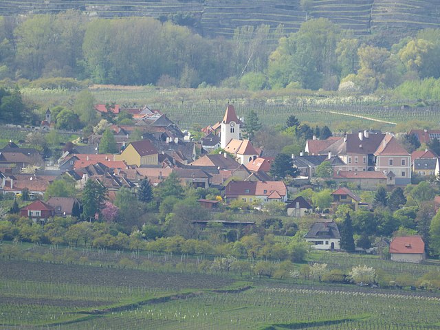
Агсбах (Aggsbach, Aggsbach)
 Hiking in Агсбах
Aggsbach is a picturesque area located in Austria, known for its stunning natural landscapes along the Danube River. While specific hiking trails may vary, there are generally several options available for different skill levels. Here are some highlights you might want to consider when planning your hiking trip in Aggsbach:
1.
Aggsbach offers beautiful scenic trails that allow you to enjoy the stunning views of the Danube Valley, vineyards, and surrounding forests. Keep an eye out for trails that provide viewpoints where you can take in the breathtaking scenery.
2.
There are hiking trails suited for various fitness levels, from easy walks suitable for families to more challenging hikes for experienced trekkers. It’s a good idea to consult local maps or guides to find trails that match your ability.
3.
While hiking, you may encounter a variety of local wildlife and plant species. The region is characterized by rich biodiversity, and birdwatchers may enjoy the variety of birds common to the area.
4.
Some trails may lead to historical sites or landmarks, such as old castles or churches, which can add an interesting cultural aspect to your hike.
5.
The best time to hike in Aggsbach is typically from spring to early autumn, when the weather is milder and the trails are more accessible. Be mindful of the weather conditions and dress accordingly.
6.
Check for local accommodations, cafes, and places to refill water along the trails before heading out. Proper preparation is essential for a safe hiking experience.
7.
If you're unfamiliar with the area, consider joining a guided hiking tour. Local guides can provide valuable insights into the region's geology, flora, and history, enhancing your hiking experience.
8.
Always inform someone about your hiking plans, carry a map or GPS, and ensure that you have enough supplies (water, snacks, first-aid kit) for your trek.
If you’re looking to explore the natural beauty and culture of Aggsbach, be sure to check local resources for the most current information and trail recommendations. Happy hiking!
- Страна:

- Телефонный код: 02712
- Код автомобильного номера: KR
- Координаты: 48° 17' 0" N, 15° 24' 0" E


- GPS треки (wikiloc): [Ссылка]
- Высота над уровнем моря: 214 м m
- Площадь: 13.72 кв.км
- Население: 643
- Википедия русская: wiki(ru)
- Википедия английская: wiki(en)
- Википедия национальная: wiki(de)
- Хранилище Wikidata: Wikidata: Q393419
- Катеория в википедии: [Ссылка]
- код Freebase: [/m/028c02p]
- код GeoNames: Альт: [2782955]
- код VIAF: Альт: [241889010]
- код австрийского муниципалитета: [31301]
Включает регионы:

Groisbach
Hiking in Groisbach
Groisbach, part of Gemeinde Aggsbach in Austria, offers a beautiful setting for hiking enthusiasts, surrounded by the scenic landscapes of the Wachau Valley. Here’s what you can expect when hiking in this area:...
- Страна:
- Координаты: 48° 18' 57" N, 15° 24' 23" E
- GPS треки (wikiloc): [Ссылка]

Köfering
Hiking in Köfering
Köfering, located in Gemeinde Aggsbach in Austria, offers a charming hiking experience surrounded by beautiful natural landscapes. The region is characterized by its picturesque valleys, forested areas, and proximity to the Danube River. Here are some highlights and tips for hiking in Köfering and its surroundings:...
- Страна:
- Координаты: 48° 18' 48" N, 15° 23' 45" E
- GPS треки (wikiloc): [Ссылка]
Граничит с регионами:

Шёнбюэль-Агсбах
Hiking in Шёнбюэль-Агсбах
Schönbühel-Aggsbach, located in the beautiful Wachau Valley in Austria, is a great destination for hiking enthusiasts. The region is known for its stunning landscapes, vineyards, and the Danube River, providing a picturesque backdrop for outdoor activities....
- Страна:
- Телефонный код: 02753
- Код автомобильного номера: ME
- Координаты: 48° 17' 31" N, 15° 24' 43" E
- GPS треки (wikiloc): [Ссылка]
- Высота над уровнем моря: 210 м m
- Площадь: 28.37 кв.км
- Население: 981
- Веб сайт: [Ссылка]


Мариа-Лах-ам-Яуэрлинг
Hiking in Мариа-Лах-ам-Яуэрлинг
Maria Laach am Jauerling, located in the picturesque region of Lower Austria, offers a variety of hiking opportunities that showcase the area's natural beauty and cultural heritage. Here are some aspects of hiking in this region:...
- Страна:
- Почтовый код: 3643
- Телефонный код: 02712
- Код автомобильного номера: KR
- Координаты: 48° 18' 11" N, 15° 20' 42" E
- GPS треки (wikiloc): [Ссылка]
- Высота над уровнем моря: 591 м m
- Площадь: 36.44 кв.км
- Население: 916
- Веб сайт: [Ссылка]

Шпиц
Hiking in Шпиц
Spitz, Austria, is a charming village located in the Wachau Valley, renowned for its stunning scenery and rich cultural history. It is a popular destination for hiking enthusiasts owing to its picturesque landscapes, vineyards, and historic sites. Here are some highlights for hiking in the area:...
- Страна:
- Почтовый код: 3620
- Телефонный код: 02713
- Код автомобильного номера: KR
- Координаты: 48° 21' 0" N, 15° 25' 0" E
- GPS треки (wikiloc): [Ссылка]
- Высота над уровнем моря: 223 м m
- Площадь: 23.83 кв.км
- Население: 1620
- Веб сайт: [Ссылка]
Россац-Арнсдорф
Hiking in Россац-Арнсдорф
Rossatz-Arnsdorf, located in the Wachau Valley of Austria, is a picturesque area known for its stunning landscapes, vineyards, and rich cultural heritage. Hiking in this region offers a variety of trails suitable for different skill levels, making it a great destination for nature enthusiasts and outdoor adventurers....
- Страна:
- Телефонный код: 02714
- Код автомобильного номера: KR
- Координаты: 48° 23' 45" N, 15° 30' 15" E
- GPS треки (wikiloc): [Ссылка]
- Высота над уровнем моря: 225 м m
- Площадь: 3904 кв.км
- Население: 1065
- Веб сайт: [Ссылка]