
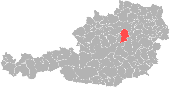
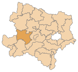
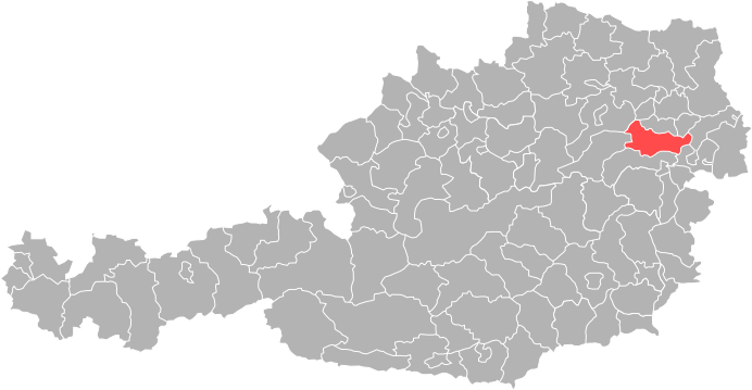
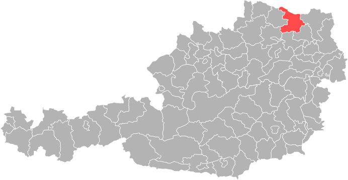
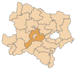
Нижняя Австрия (Lower Austria, Niederösterreich)


- федеральная земля Австрии
 Hiking in Нижняя Австрия
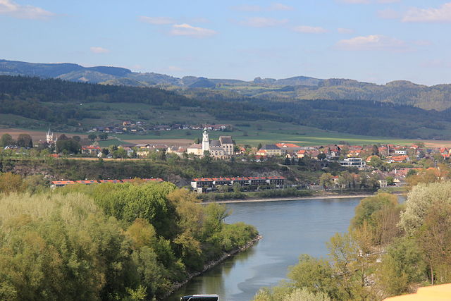
Lower Austria, known as Niederösterreich in German, is a fantastic destination for hiking enthusiasts. The region is characterized by its diverse landscapes, including rolling hills, vineyards, forests, and the scenic Danube River. Here are some highlights and popular hiking areas in Lower Austria:
1.
- This UNESCO World Heritage site is famous for its stunning vineyards, charming villages, and terraced hillsides along the Danube. There are various well-marked hiking trails, such as the Wachau World Heritage Trail, which offers spectacular views and opportunities to visit historic castles and abbeys.
2.
- The Vienna Woods offer a vast network of trails just a short distance from the capital. Popular trails include those around the Lainzer Tiergarten, an area rich in wildlife with beautiful views of Vienna. The area is excellent for day hikes and leisurely strolls amidst nature.
3.
- Located southwest of Vienna, this park offers numerous hiking trails through varied terrain, including forests and hills. The routes vary from easy to moderately challenging, making it accessible for hikers of all skill levels.
4.
- This area features more rugged landscapes, with trails that lead to stunning peaks and panoramic views. Popular spots include the Schneeberg and Rax mountains, which offer more challenging hikes, including routes like the Rax cable car hike, leading to breathtaking alpine scenery.
5.
- A region known for its flat terrain, the Marchfeld offers easier hiking opportunities, ideal for families. Trails here often pass through fields and along rivers, providing a different experience from the mountainous areas.
6.
- While primarily a cycling route, portions of this path are also great for hiking. Following the Danube through picturesque towns and lush landscapes can make for a pleasant long-distance hike.
Tips for Hiking in Lower Austria:
- Trail Markings: Ensure you are familiar with the local trail markings and maps. Hiking paths are generally well-marked, but it's wise to have a map or a reliable hiking app.
- Weather: Check the weather before heading out, as conditions can change rapidly in the mountains.
- Equipment: Wear proper hiking shoes that provide good support. Depending on the trail, consider trekking poles, especially in more rugged areas.
- Hydration and Snacks: Always carry enough water and snacks, particularly on longer hikes.
- Respect Nature: Follow Leave No Trace principles to preserve the beautiful landscapes.
Whether you're looking for a day hike or a more challenging trekking experience, Lower Austria has something to offer every hiker. Enjoy your adventure in this beautiful region!
- Страна:

- Столица: Санкт-Пёльтен
- Координаты: 48° 20' 0" N, 15° 45' 0" E


- GPS треки (wikiloc): [Ссылка]
- Высота над уровнем моря: 279 м m
- Площадь: 19186.0 кв.км
- Население: 1653419
- Веб сайт: http://www.noe.gv.at/
- Википедия русская: wiki(ru)
- Википедия английская: wiki(en)
- Википедия национальная: wiki(de)
- Хранилище Wikidata: Wikidata: Q42497
- Галерея изображений в википедии: [Ссылка]
- Катеория в википедии: [Ссылка]
- Карты в википедии: [Ссылка]
- код Freebase: [/m/0133h8]
- код GeoNames: Альт: [2770542]
- код BNF: [11936270n]
- код VIAF: Альт: [147169281]
- код GND: Альт: [4075391-8]
- идентификатор местоположения ArchINFORM: [2864]
- код LCNAF: Альт: [n79079223]
- место в MusicBrainz: [3daad85f-1712-476d-8c44-7a76969231ca]
- код темы Quora: [Lower-Austria]
- код TGN: [7003025]
- код в энциклопедии «Британника онлайн»: [place/Niederosterreich]
- код в Encyclopædia Universalis: [basse-autriche]
- код NKC: [ge134134]
- dmoz: Альт: [Regional/Europe/Austria/Provinces/Lower_Austria/]
- код NUTS: [AT12]
- код статьи Klexikon: [Niederösterreich]
- STW Thesaurus for Economics ID: [16948-5]
- ISO 3166-2: AT-3
- FIPS 10-4: AU03
Включает регионы:
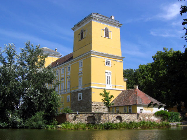
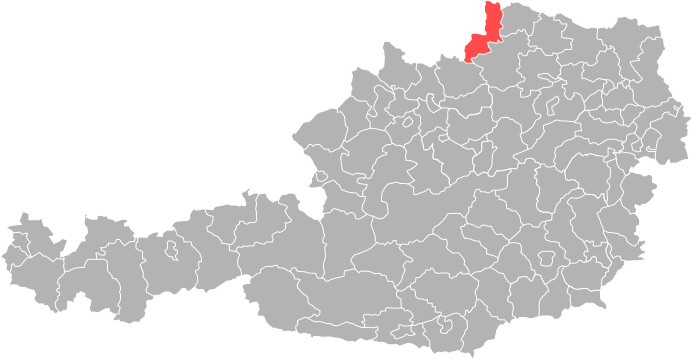
Кремс-ан-дер-Донау
- город в Австрии
Hiking in Кремс-ан-дер-Донау
Krems an der Donau is a picturesque town in Lower Austria, situated at the confluence of the Danube River and the Krems River. It is surrounded by beautiful landscapes, vineyards, and the scenic rolling hills of the Wachau Valley, making it a great destination for hiking enthusiasts. Here are some highlights and tips for hiking in and around Krems an der Donau:...
- Страна:
- Почтовый код: 3500
- Код автомобильного номера: KS
- Координаты: 48° 25' 0" N, 15° 37' 0" E
- GPS треки (wikiloc): [Ссылка]
- Высота над уровнем моря: 203 м m
- Площадь: 51.61 кв.км
- Население: 24610
- Веб сайт: [Ссылка]

Винер-Нойштадт
Hiking in Винер-Нойштадт
Wiener Neustadt, located in Lower Austria, offers several hiking opportunities for outdoor enthusiasts. The region is characterized by a mix of stunning natural landscapes, historical sites, and diverse trails suitable for various skill levels. Here are some highlights and tips for hiking in Wiener Neustadt:...
- Страна:
- Почтовый код: 2700
- Телефонный код: 02622
- Код автомобильного номера: WN
- Координаты: 47° 49' 0" N, 16° 15' 0" E
- GPS треки (wikiloc): [Ссылка]
- Высота над уровнем моря: 265 м m
- Площадь: 60.94 кв.км
- Население: 44461
- Веб сайт: [Ссылка]


Хорн
- округ в Австрии, Нижняя Австрия
Hiking in Хорн
Hiking in the Horn District of India, which includes parts of states such as Arunachal Pradesh, Assam, Meghalaya, and Manipur, offers a rich blend of natural beauty, cultural experiences, and biodiversity. Here are some key points you should know when considering hiking in this region:...
- Страна:
- Столица: Хорн
- Код автомобильного номера: HO
- Координаты: 48° 39' 50" N, 15° 39' 26" E
- GPS треки (wikiloc): [Ссылка]
- Высота над уровнем моря: 462 м m
- Площадь: 783.99 кв.км
- Веб сайт: [Ссылка]

Шайбс
Hiking in Шайбс
Scheibbs District, located in the Lower Austria region of Austria, is known for its beautiful landscapes, rich cultural heritage, and a variety of hiking opportunities. Here are some highlights for hiking in this area:...
- Страна:
- Код автомобильного номера: SB
- Координаты: 48° 0' 40" N, 15° 5' 20" E
- GPS треки (wikiloc): [Ссылка]
- Высота над уровнем моря: 463 м m
- Площадь: 1023 кв.км
- Веб сайт: [Ссылка]


Мёдлинг
- округ федеральной земли Нижняя Австрия
Hiking in Мёдлинг
Mödling District, located just south of Vienna in Austria, offers a beautiful blend of natural landscapes and historical sites, making it a fantastic destination for hiking enthusiasts. Here are some highlights about hiking in the area:...
- Страна:
- Код автомобильного номера: MD
- Координаты: 48° 5' 42" N, 16° 14' 20" E
- GPS треки (wikiloc): [Ссылка]
- Высота над уровнем моря: 260 м m
- Площадь: 277.02 кв.км
- Веб сайт: [Ссылка]

Мистельбах
Hiking in Мистельбах
Mistelbach District, located in the northeastern part of Austria, offers a variety of beautiful hiking opportunities amidst its picturesque landscapes. The region is characterized by rolling hills, vineyards, and scenic views, making it a great destination for hikers of all levels....
- Страна:
- Код автомобильного номера: MI
- Координаты: 48° 38' 38" N, 16° 30' 7" E
- GPS треки (wikiloc): [Ссылка]
- Высота над уровнем моря: 220 м m
- Площадь: 1291.30 кв.км
- Веб сайт: [Ссылка]
Мельк
Hiking in Мельк
The Melk District, located in Lower Austria, is an excellent destination for hiking enthusiasts. This region is characterized by its scenic landscapes, rich history, and diverse trails suitable for various skill levels. Here are some highlights about hiking in the Melk District:...
- Страна:
- Код автомобильного номера: ME
- Координаты: 48° 12' 0" N, 15° 12' 14" E
- GPS треки (wikiloc): [Ссылка]
- Высота над уровнем моря: 220 м m
- Площадь: 1013.62 кв.км
- Веб сайт: [Ссылка]

Баден
- округ в Австрии, Нижняя Австрия
Hiking in Баден
Baden District, located in the Lower Austria region, is an excellent destination for hiking enthusiasts. Known for its beautiful landscapes, rolling hills, and thermal springs, it offers a variety of trails suited for all experience levels. Here are some highlights and tips for hiking in the Baden District:...
- Страна:
- Столица: Баден
- Код автомобильного номера: BN
- Координаты: 48° 0' 12" N, 16° 13' 52" E
- GPS треки (wikiloc): [Ссылка]
- Высота над уровнем моря: 357 м m
- Площадь: 753.37 кв.км
- Веб сайт: [Ссылка]


Вайдхофен-на-Ибсе
Hiking in Вайдхофен-на-Ибсе
Waidhofen an der Ybbs, located in Upper Austria, is a picturesque town surrounded by beautiful natural landscapes, making it an excellent destination for hiking enthusiasts. Here are some highlights and insights into hiking in this region:...
- Страна:
- Почтовый код: 3340
- Телефонный код: 07442
- Код автомобильного номера: WY
- Координаты: 47° 58' 0" N, 14° 46' 0" E
- GPS треки (wikiloc): [Ссылка]
- Высота над уровнем моря: 356 м m
- Площадь: 131.57 кв.км
- Население: 11333
- Веб сайт: [Ссылка]


Вена
Hiking in Вена
Wien-Umgebung, or the Vienna Surroundings District, offers a variety of beautiful hiking opportunities right outside the bustling capital of Austria. Here are some highlights and features of hiking in this region:...
- Страна:
- Столица: Клостернойбург
- Код автомобильного номера: WU
- Координаты: 48° 18' 0" N, 16° 19' 0" E
- GPS треки (wikiloc): [Ссылка]
- Высота над уровнем моря: 346 м m
- Площадь: 484.48 кв.км
- Веб сайт: [Ссылка]


Брук-на-Лайте
Hiking in Брук-на-Лайте
Bruck an der Leitha District, located in Austria near the borders with Slovakia and Hungary, offers a variety of hiking opportunities that showcase its natural beauty and historical significance. Here are some key features to consider when hiking in this area:...
- Страна:
- Координаты: 48° 4' 1" N, 16° 46' 44" E
- GPS треки (wikiloc): [Ссылка]
- Высота над уровнем моря: 201 м m
- Площадь: 494.95 кв.км
- Население: 44969
- Веб сайт: [Ссылка]


Вайдхофен
Hiking in Вайдхофен
Waidhofen an der Thaya District, located in the northeastern part of Austria, is a hidden gem for hiking enthusiasts. The region is characterized by its rolling hills, dense forests, and picturesque landscapes, making it an excellent destination for outdoor activities....
- Страна:
- Столица: Вайдхофен-ан-дер-Тайя
- Код автомобильного номера: WT
- Координаты: 48° 50' 38" N, 15° 17' 56" E
- GPS треки (wikiloc): [Ссылка]
- Высота над уровнем моря: 579 м m
- Площадь: 669.14 кв.км
- Веб сайт: [Ссылка]

Холлабрунн
Hiking in Холлабрунн
Hollabrunn District, located in the northeastern part of Austria, is a charming area filled with scenic landscapes and a variety of hiking opportunities. Here are some highlights and tips for hiking in this district:...
- Страна:
- Код автомобильного номера: HL
- Координаты: 48° 38' 56" N, 16° 1' 1" E
- GPS треки (wikiloc): [Ссылка]
- Высота над уровнем моря: 275 м m
- Площадь: 1010.72 кв.км
- Веб сайт: [Ссылка]

Корнейбург
Hiking in Корнейбург
Korneuburg District, located just north of Vienna in Austria, offers a variety of hiking opportunities that showcase the scenic beauty of the region. Here are some highlights and tips for hiking in the area:...
- Страна:
- Код автомобильного номера: KO
- Координаты: 48° 23' 31" N, 16° 15' 29" E
- GPS треки (wikiloc): [Ссылка]
- Высота над уровнем моря: 189 м m
- Площадь: 626.50 кв.км
- Население: 88599
- Веб сайт: [Ссылка]


Нойнкирхен
- округ в Австрии, Нижняя Австрия
Hiking in Нойнкирхен
Neunkirchen District, located in the state of Lower Austria, offers a variety of hiking opportunities amidst beautiful natural landscapes, charming villages, and historical sites. Here are some highlights to consider when hiking in the region:...
- Страна:
- Код автомобильного номера: NK
- Координаты: 47° 43' 37" N, 16° 4' 54" E
- GPS треки (wikiloc): [Ссылка]
- Высота над уровнем моря: 572 м m
- Площадь: 1146 кв.км
- Веб сайт: [Ссылка]

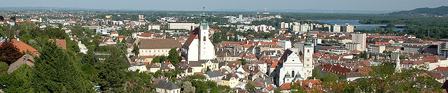
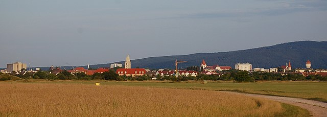
Санкт-Пёльтен
Hiking in Санкт-Пёльтен
Sankt Pölten-Land District, located in the Lower Austria region of Austria, is a scenic area that offers numerous hiking opportunities amidst beautiful landscapes, cultural heritage, and nature reserves. Here are some highlights and tips for hiking in this district:...
- Страна:
- Код автомобильного номера: PL
- Координаты: 48° 10' 59" N, 15° 40' 1" E
- GPS треки (wikiloc): [Ссылка]
- Высота над уровнем моря: 313 м m
- Площадь: 1121.61 кв.км
- Веб сайт: [Ссылка]


Кремс-Ланд
Hiking in Кремс-Ланд
Krems-Land District, located in the foothills of the Austrian Alps and close to the picturesque Wachau Valley, offers a variety of hiking opportunities for outdoor enthusiasts. Here are some key points about hiking in this beautiful region:...
- Страна:
- Код автомобильного номера: KR
- Координаты: 48° 27' 0" N, 15° 34' 1" E
- GPS треки (wikiloc): [Ссылка]
- Площадь: 923.95 кв.км


Винер-Нойштадт
- округ в Австрии, Нижняя Австрия
Hiking in Винер-Нойштадт
Wiener Neustadt-Land District, located in the state of Lower Austria, offers a range of excellent hiking opportunities that cater to various skill levels. The region features beautiful landscapes, including rolling hills, forests, and meadows, providing a scenic backdrop for outdoor enthusiasts....
- Страна:
- Столица: Винер-Нойштадт
- Код автомобильного номера: WB
- Координаты: 47° 37' 21" N, 16° 20' 27" E
- GPS треки (wikiloc): [Ссылка]
- Высота над уровнем моря: 445 м m
- Площадь: 969.72 кв.км
- Веб сайт: [Ссылка]

Гмюнд
Hiking in Гмюнд
Gmünd District, located in the state of Carinthia in Austria, offers a beautiful setting for hiking enthusiasts, with a mix of stunning landscapes, diverse trails, and a rich natural environment. Here are some highlights and tips for hiking in the Gmünd District:...
- Страна:
- Столица: Гмюнд
- Код автомобильного номера: GD
- Координаты: 48° 46' 0" N, 14° 59' 0" E
- GPS треки (wikiloc): [Ссылка]
- Высота над уровнем моря: 529 м m
- Площадь: 786.24 кв.км
- Веб сайт: [Ссылка]

Тульн
Hiking in Тульн
Tulln District, located in Lower Austria, offers a variety of hiking opportunities that showcase the region's stunning landscapes, rich history, and natural beauty. Here are some highlights and considerations for hiking in this area:...
- Страна:
- Код автомобильного номера: TU
- Координаты: 48° 19' 48" N, 15° 58' 48" E
- GPS треки (wikiloc): [Ссылка]
- Площадь: 734.00 кв.км
- Веб сайт: [Ссылка]


Гензерндорф
Hiking in Гензерндорф
Gänserndorf District, located in the northeastern part of Austria, offers a variety of hiking opportunities that showcase its scenic beauty and rich natural landscapes. Here are some aspects to consider when planning a hiking trip in this area:...
- Страна:
- Код автомобильного номера: GF
- Координаты: 48° 20' 28" N, 16° 43' 5" E
- GPS треки (wikiloc): [Ссылка]
- Высота над уровнем моря: 173 м m
- Площадь: 1271.31 кв.км
- Веб сайт: [Ссылка]

Амштеттен
Hiking in Амштеттен
Amstetten District, located in the Lower Austria region of Austria, offers a variety of hiking opportunities for outdoor enthusiasts. The region is characterized by its diverse landscapes, which include hills, forests, and charming rural scenery, making it an appealing destination for both casual walkers and experienced hikers....
- Страна:
- Столица: Амштеттен
- Код автомобильного номера: AM
- Координаты: 48° 7' 0" N, 14° 52' 0" E
- GPS треки (wikiloc): [Ссылка]
- Высота над уровнем моря: 602 м m
- Площадь: 1187.97 кв.км
- Население: 115676
- Веб сайт: [Ссылка]

Цветль
Hiking in Цветль
Zwettl District, located in the Waldviertel region of Austria, offers a picturesque setting for hiking enthusiasts. The area is characterized by its diverse landscapes, including forests, rolling hills, and charming villages, making it a great destination for both casual walkers and experienced hikers....
- Страна:
- Код автомобильного номера: ZT
- Координаты: 48° 34' 52" N, 15° 9' 7" E
- GPS треки (wikiloc): [Ссылка]
- Высота над уровнем моря: 665 м m
- Площадь: 1399.76 кв.км
- Веб сайт: [Ссылка]


Лилинфельд
Hiking in Лилинфельд
The Lilienfeld District, located in Lower Austria, offers a variety of hiking opportunities that cater to different skill levels and interests. The region is characterized by its beautiful landscapes, picturesque forests, and the famous northern foothills of the Alps. Here are some highlights of hiking in this area:...
- Страна:
- Код автомобильного номера: LF
- Координаты: 48° 0' 47" N, 15° 36' 32" E
- GPS треки (wikiloc): [Ссылка]
- Высота над уровнем моря: 588 м m
- Площадь: 931.55 кв.км
- Веб сайт: [Ссылка]

Санкт-Пёльтен
Hiking in Санкт-Пёльтен
Sankt Pölten, the capital of Lower Austria, offers a variety of hiking opportunities that cater to different skill levels and preferences. Here are some noteworthy aspects of hiking in and around Sankt Pölten:...
- Страна:
- Почтовый код: 3100
- Телефонный код: 02742
- Код автомобильного номера: P
- Координаты: 48° 12' 0" N, 15° 37' 0" E
- GPS треки (wikiloc): [Ссылка]
- Высота над уровнем моря: 267 м m
- Площадь: 108.52 кв.км
- Население: 53445
- Веб сайт: [Ссылка]
Граничит с регионами:


Вена
- столица Австрии
Hiking in Вена
As a hiking instructor, I'd be happy to tell you about hiking opportunities in Vienna! While Vienna is primarily known for its rich history, art, and culture, it also offers beautiful natural spaces perfect for hiking. Here are some of the top spots:...
- Страна:
- Почтовый код: 1901; 1810; 1600–1601; 1502–1503; 1500; 1423; 1421; 1300–1301; 1251–1255; 1402; 1400; 1000–1239
- Телефонный код: 01
- Код автомобильного номера: W
- Координаты: 48° 12' 30" N, 16° 22' 23" E
- GPS треки (wikiloc): [Ссылка]
- Высота над уровнем моря: 542 м m
- Площадь: 414.87 кв.км
- Население: 1840573
- Веб сайт: [Ссылка]


Дёблинг
- округ Вены
Hiking in Дёблинг
Döbling is a charming district in Vienna, Austria, known for its scenic landscapes, vineyards, and proximity to the Vienna Woods (Wienerwald). Here are some highlights and tips for hiking in Döbling:...
- Страна:
- Почтовый код: 1190
- Код автомобильного номера: W
- Координаты: 48° 15' 59" N, 16° 19' 22" E
- GPS треки (wikiloc): [Ссылка]
- Высота над уровнем моря: 247 м m
- Площадь: 24.9 кв.км
- Веб сайт: [Ссылка]


Штирия
- земля Австрии
Hiking in Штирия
Styria, a beautiful region in Austria, is a fantastic destination for hiking enthusiasts. Known for its diverse landscapes, lush forests, rolling hills, and stunning alpine views, Styria offers a variety of trails suitable for all experience levels. Here’s what you can expect when hiking in Styria:...
- Страна:
- Столица: Грац
- Координаты: 47° 15' 0" N, 15° 10' 0" E
- GPS треки (wikiloc): [Ссылка]
- Высота над уровнем моря: 2995 м m
- Площадь: 16400.75 кв.км
- Население: 1231865
- Веб сайт: [Ссылка]


Верхняя Австрия
Hiking in Верхняя Австрия
Upper Austria, or "Oberösterreich," offers a diverse range of hiking opportunities, making it a great destination for both beginners and experienced hikers alike. The region is characterized by its picturesque landscapes, including rolling hills, lush valleys, and rugged mountain ranges. Here are some highlights of hiking in Upper Austria:...
- Страна:
- Столица: Линц
- Координаты: 48° 12' 0" N, 14° 0' 0" E
- GPS треки (wikiloc): [Ссылка]
- Высота над уровнем моря: 343 м m
- Площадь: 11981.92 кв.км
- Население: 1453733
- Веб сайт: [Ссылка]


Бургенланд
- Земля в Австрии
Hiking in Бургенланд
Burgenland, located in the eastern part of Austria, is a fantastic destination for hiking enthusiasts. This region is known for its diverse landscapes, including rolling hills, vineyards, and scenic views of Lake Neusiedl, which is Central Europe's largest steppe lake. Here are some key aspects of hiking in Burgenland:...
- Страна:
- Столица: Айзенштадт
- Координаты: 47° 30' 0" N, 16° 25' 0" E
- GPS треки (wikiloc): [Ссылка]
- Высота над уровнем моря: 333 м m
- Площадь: 3961.8 кв.км
- Население: 291023
- Веб сайт: [Ссылка]