Альдранс (Aldrans, Aldrans)

 Hiking in Альдранс
Aldrans is a picturesque village located in the Tyrol region of Austria, just a few kilometers from Innsbruck. Its location near the mountains makes it an excellent base for hiking enthusiasts. Here are some highlights and suggestions for hiking in and around Aldrans:
Hiking Trails
-
Nordkette Mountain Range: Just a short distance away from Aldrans, this mountain range offers various trails with stunning views of the Inn Valley and Innsbruck. The trails range from easy walks to more challenging hikes.
-
Aldranser Alm: A popular destination, this alpine hut can be reached via a moderate hike. The trail leads through scenic meadows and forests, offering beautiful views along the way. The Alm itself often serves local Tyrolean specialties.
-
Heiligwasserweg: This is a lovely trail leading to the Heiligwasser chapel and offers a peaceful hiking experience with nature trails, streams, and the charm of local history.
-
Muttereralm: A bit further from Aldrans, but easily reachable, this area offers a range of hiking options suitable for different skill levels. The Muttereralm is also a great place for families, with various trails designed for children's enjoyment.
Tips for Hiking in Aldrans
- Trail Conditions: Always check the conditions and paths, as some trails can vary in difficulty and maintenance.
- Equipment: Wear sturdy hiking shoes and bring appropriate clothing. Weather can change rapidly in the Alps.
- Water and Snacks: Carry enough water and snacks, especially if you plan to hike longer trails.
- Maps and Navigation: It's advisable to have a local hiking map or a GPS device for navigation, as some trails may not be well-marked.
- Local Insights: For updated trail information, consider checking in with local tourism offices or hiking groups.
Best Time to Hike
The best times for hiking in the Aldrans area are typically late spring through early autumn (May to September), when the weather is milder, and trails are accessible. Higher elevation trails may have snow until late spring, so plan accordingly.
Safety Measures
Always prioritize your safety while hiking. Make sure to let someone know your plans, carry a fully charged phone, and be prepared for emergencies.
In summary, hiking in Aldrans offers a blend of beautiful landscapes, cultural heritage, and outdoor recreation, making it a rewarding experience for hikers of all levels. Enjoy your adventure!
- Страна:

- Почтовый код: 6071
- Телефонный код: 0512
- Код автомобильного номера: IL
- Координаты: 47° 15' 0" N, 11° 26' 0" E


- GPS треки (wikiloc): [Ссылка]
- Высота над уровнем моря: 760 м m
- Площадь: 8.89 кв.км
- Население: 2684
- Веб сайт: http://www.aldrans.at/
- Википедия русская: wiki(ru)
- Википедия английская: wiki(en)
- Википедия национальная: wiki(de)
- Хранилище Wikidata: Wikidata: Q670188
- Катеория в википедии: [Ссылка]
- код Freebase: [/m/027xj1t]
- код GeoNames: Альт: [2782813]
- код VIAF: Альт: [244711819]
- код GND: Альт: [4342300-0]
- идентификатор местоположения ArchINFORM: [1336]
- WOEID: [550419]
- код австрийского муниципалитета: [70302]
Граничит с регионами:

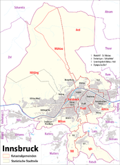
Инсбрук
- город, административный центр федеральной земли Тироль, Австрия
Hiking in Инсбрук
Innsbruck, located in the heart of the Austrian Alps, is a fantastic destination for hikers of all skill levels. Surrounded by stunning mountain ranges, including the Nordkette, Patscherkofel, and Axamer Lizum, there are numerous trails offering breathtaking views, diverse landscapes, and varying degrees of difficulty....
- Страна:
- Почтовый код: 6080; 6010–6040; 6020
- Телефонный код: 0512
- Код автомобильного номера: I
- Координаты: 47° 16' 0" N, 11° 23' 0" E
- GPS треки (wikiloc): [Ссылка]
- Высота над уровнем моря: 574 м m
- Площадь: 105 кв.км
- Население: 130894
- Веб сайт: [Ссылка]