
Тироль (Tyrol, Tirol)


- федеральная земля Австрии
 Hiking in Тироль
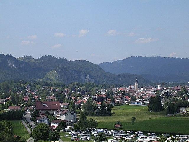
Tyrol, located in the Austrian Alps, is a paradise for hiking enthusiasts, offering a diverse array of trails that cater to all skill levels. The landscape is characterized by stunning mountain vistas, lush valleys, sparkling lakes, and charming alpine villages, making it a perfect setting for outdoor activities.
Key Highlights of Hiking in Tyrol:
-
Diverse Terrain: Tyrol boasts a variety of hiking experiences, from gentle valley walks to challenging mountain ascents. Trails range from well-marked paths perfect for families to strenuous hikes that lead to breathtaking mountain summits.
-
Famous Regions:
- Ötztal Valley: Known for its dramatic landscapes and high mountain passes, it offers routes like the Ötztaler Höhenweg, a multi-day trek that showcases incredible alpine scenery.
- Stubai Valley: Home to the Stubai Glacier, this area features trails with panoramic views and opportunities for year-round hiking.
- Zillertal Valley: Offers a mix of leisure and challenging hikes, including routes that lead to picturesque lakes and stunning viewpoints.
- Innsbruck: The capital city also offers nearby trails that allow hikers to explore the surrounding mountains easily.
-
Scenic Trails: Some popular hikes include:
- Eagle Walk: A long-distance trail that traverses the whole of Tyrol, covering around 413 kilometers and offering gorgeous views.
- Fagaras Hiking Trail: Known for breathtaking panoramic views and beautiful natural landscapes.
- Nordkette Range: Easily accessible from Innsbruck, it features breathtaking views and a range of trail difficulties.
-
Alpine Huts: Along many trails, you'll find traditional alpine huts (Almhütten) where hikers can rest and enjoy local Tyrolean cuisine. These huts provide an ideal way to experience the culture and hospitality of the region.
-
Best Time to Hike: While summer (June to September) is the most popular season due to clear weather, spring and autumn also offer beautiful hiking opportunities with fewer crowds. Winter hiking is possible on designated trails, although snow conditions should be checked.
-
Safety and Preparation: It’s essential to prepare adequately for hikes in Tyrol. Wear suitable footwear, check weather conditions, and carry sufficient water and snacks. For high-altitude hikes, consider altitude acclimatization and follow usual mountain safety precautions.
-
Guided Tours: If you prefer a structured experience, many local companies offer guided hiking tours that explore the region's hidden gems and provide insights into local flora, fauna, and culture.
In summary, Tyrol is an exceptional destination for hiking with its stunning scenery, extensive network of trails, and welcoming alpine culture. Whether you are a beginner or an experienced hiker, you will find numerous hiking options that will make your adventure memorable.
- Страна:

- Столица: Инсбрук
- Координаты: 47° 16' 0" N, 11° 24' 0" E


- GPS треки (wikiloc): [Ссылка]
- Высота над уровнем моря: 605 м m
- Площадь: 12647.71 кв.км
- Население: 739002
- Веб сайт: http://www.tirol.gv.at/
- Википедия русская: wiki(ru)
- Википедия английская: wiki(en)
- Википедия национальная: wiki(de)
- Хранилище Wikidata: Wikidata: Q42880
- Галерея изображений в википедии: [Ссылка]
- Катеория в википедии: [Ссылка]
- Карты в википедии: [Ссылка]
- код Freebase: [/m/0133jj]
- код GeoNames: Альт: [2763586]
- код BNF: [119782970]
- код VIAF: Альт: [153542768]
- идентификатор местоположения ArchINFORM: [2932]
- код LCNAF: Альт: [n79139014]
- код тезауруса PACTOLS: [pcrtYZnYTXXqPI]
- место в MusicBrainz: [94c82f6a-70ed-485e-aaa2-5dcf11f80e98]
- код темы Quora: [Tyrol]
- код TGN: [7003029]
- код ISNI: Альт: [0000 0004 0437 6152]
- код NKC: [ge883507]
- dmoz: Альт: [Regional/Europe/Austria/Provinces/Tyrol/]
- код NUTS: [AT33]
- код YSO: [118609]
- код статьи Klexikon: [Tirol]
- STW Thesaurus for Economics ID: [16953-5]
- ISO 3166-2: AT-7
- FIPS 10-4: AU07
Включает регионы:

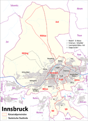
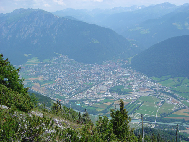
Инсбрук
- город, административный центр федеральной земли Тироль, Австрия
Hiking in Инсбрук
Innsbruck, located in the heart of the Austrian Alps, is a fantastic destination for hikers of all skill levels. Surrounded by stunning mountain ranges, including the Nordkette, Patscherkofel, and Axamer Lizum, there are numerous trails offering breathtaking views, diverse landscapes, and varying degrees of difficulty....
- Страна:
- Почтовый код: 6080; 6010–6040; 6020
- Телефонный код: 0512
- Код автомобильного номера: I
- Координаты: 47° 16' 0" N, 11° 23' 0" E
- GPS треки (wikiloc): [Ссылка]
- Высота над уровнем моря: 574 м m
- Площадь: 105 кв.км
- Население: 130894
- Веб сайт: [Ссылка]


Лиенц
Hiking in Лиенц
Lienz District, located in the eastern part of Tyrol, Austria, is a stunning area for hiking, known for its breathtaking alpine landscapes, picturesque villages, and a variety of trails suitable for all levels of hikers. Here are some key highlights and recommendations for hiking in this beautiful region:...
- Страна:
- Столица: Лиенц
- Код автомобильного номера: LZ
- Координаты: 46° 49' 0" N, 12° 46' 0" E
- GPS треки (wikiloc): [Ссылка]
- Высота над уровнем моря: 1961 м m
- Площадь: 2019.87 кв.км
- Население: 49033
- Веб сайт: [Ссылка]

Куфштайн
Hiking in Куфштайн
The Kufstein District, located in the federal state of Tyrol, Austria, is a fantastic area for hiking enthusiasts. It features stunning alpine landscapes, charming villages, and well-established trails that cater to various skill levels....
- Страна:
- Столица: Куфштайн
- Код автомобильного номера: KU
- Координаты: 47° 30' 0" N, 12° 6' 0" E
- GPS треки (wikiloc): [Ссылка]
- Высота над уровнем моря: 646 м m
- Площадь: 969.90 кв.км
- Население: 105466
- Веб сайт: [Ссылка]

Кицбюэль
Hiking in Кицбюэль
Kitzbühel District, located in the Tyrol region of Austria, is a stunning destination for hiking enthusiasts. With its majestic mountains, lush valleys, and picturesque alpine villages, it offers a variety of hiking trails suitable for all levels, from beginners to experienced trekkers....
- Страна:
- Столица: Кицбюэль
- Код автомобильного номера: KB
- Координаты: 47° 30' 0" N, 12° 24' 0" E
- GPS треки (wikiloc): [Ссылка]
- Высота над уровнем моря: 1085 м m
- Площадь: 1163.28 кв.км
- Население: 63125
- Веб сайт: [Ссылка]


Швац
Hiking in Швац
Hiking in the Schwaz District, located in Tyrol, Austria, offers stunning landscapes, varied terrain, and a rich cultural experience. The area is surrounded by the impressive mountain ranges of the Alps, making it a fantastic location for both casual hikers and experienced trekkers....
- Страна:
- Столица: Швац
- Код автомобильного номера: SZ
- Координаты: 47° 24' 0" N, 11° 48' 0" E
- GPS треки (wikiloc): [Ссылка]
- Высота над уровнем моря: 1676 м m
- Площадь: 1843 кв.км
- Население: 81841
- Веб сайт: [Ссылка]

Ландек
Hiking in Ландек
Landeck District, situated in the Tyrol region of Austria, offers a wealth of hiking opportunities, characterized by its stunning landscapes, diverse terrain, and rich natural beauty. Here’s an overview of what you can expect when hiking in this region:...
- Страна:
- Столица: Ландек
- Код автомобильного номера: LA
- Координаты: 47° 6' 0" N, 10° 30' 0" E
- GPS треки (wikiloc): [Ссылка]
- Высота над уровнем моря: 1091 м m
- Площадь: 1594.81 кв.км
- Население: 44189
- Веб сайт: [Ссылка]


Имст
Hiking in Имст
The Imst District, located in the Tyrol region of Austria, is a fantastic destination for hiking enthusiasts. Known for its stunning Alpine landscapes, varied terrain, and charming villages, the area offers a wide range of hiking trails suitable for all skill levels, from beginner to advanced climbers....
- Страна:
- Столица: Имст
- Код автомобильного номера: IM
- Координаты: 47° 6' 0" N, 10° 54' 0" E
- GPS треки (wikiloc): [Ссылка]
- Высота над уровнем моря: 2627 м m
- Площадь: 1724.82 кв.км
- Население: 58214
- Веб сайт: [Ссылка]


Инсбрук
Hiking in Инсбрук
Innsbruck-Land District, located in the Tyrol region of Austria, offers a remarkable hiking experience due to its stunning landscapes, diverse terrain, and a variety of trails suitable for all skill levels. Here are some highlights and tips for hiking in this picturesque area:...
- Страна:
- Столица: Инсбрук
- Код автомобильного номера: IL
- Координаты: 47° 12' 0" N, 11° 24' 0" E
- GPS треки (wikiloc): [Ссылка]
- Высота над уровнем моря: 1931 м m
- Площадь: 1990.09 кв.км
- Веб сайт: [Ссылка]
Ройтте (округ)
Hiking in Ройтте (округ)
The Reutte District, located in the Tyrol region of Austria, is known for its stunning natural landscapes, charming villages, and a variety of hiking trails suitable for all levels of hikers. Here are some key aspects of hiking in this area:...
- Страна:
- Столица: Ройтте
- Код автомобильного номера: RE
- Координаты: 47° 24' 0" N, 10° 30' 0" E
- GPS треки (wikiloc): [Ссылка]
- Высота над уровнем моря: 1222 м m
- Площадь: 1236.82 кв.км
- Население: 32023
- Веб сайт: [Ссылка]
Граничит с регионами:
Граубюнден
- кантон в Швейцарии
Hiking in Граубюнден
The Canton of Grisons, or Graubünden, is a breathtaking region in Switzerland known for its stunning landscapes, diverse hiking trails, and rich cultural heritage. Here are some highlights of hiking in this beautiful area:...
- Страна:

- Столица: Кур
- Код автомобильного номера: GR
- Координаты: 46° 45' 0" N, 9° 30' 0" E
- GPS треки (wikiloc): [Ссылка]
- Высота над уровнем моря: 585 м m
- Площадь: 7105.39 кв.км
- Веб сайт: [Ссылка]

Трентино — Альто-Адидже
- регион в Италии
Hiking in Трентино — Альто-Адидже
Trentino-Alto Adige/Südtirol is a stunning region in northern Italy, known for its breathtaking landscapes, rich culture, and a diverse array of hiking opportunities. Here's an overview of what to expect when hiking in this beautiful area:...
- Страна:

- Столица: Тренто
- Координаты: 46° 23' 0" N, 11° 25' 0" E
- GPS треки (wikiloc): [Ссылка]
- Высота над уровнем моря: 749 м m
- Площадь: 13606.87 кв.км
- Население: 1068264
- Веб сайт: [Ссылка]
Венеция
- регион в Италии
Hiking in Венеция
Hiking in the Veneto region of Italy offers a diverse range of landscapes and experiences, from the idyllic foothills of the Alps to the scenic paths along the Adriatic coast. Here are some highlights and notable trails to consider:...
- Страна:
- Столица: Венеция
- Координаты: 45° 44' 0" N, 11° 51' 0" E
- GPS треки (wikiloc): [Ссылка]
- Высота над уровнем моря: 180 м m
- Площадь: 18339 кв.км
- Население: 4925737
- Веб сайт: [Ссылка]


Больцано
- провинция в регионе Трентино — Альто-Адидже, Италия
Hiking in Больцано
South Tyrol, located in northern Italy, is a paradise for hikers and outdoor enthusiasts. This stunning region is characterized by its dramatic landscapes, which include the towering peaks of the Dolomites, lush valleys, and picturesque alpine meadows. Here are some key points about hiking in South Tyrol:...
- Страна:
- Столица: Больцано
- Почтовый код: 39010–39059; 39100
- Телефонный код: 0471; 0463; 0474; 0473; 0472
- Код автомобильного номера: BZ
- Координаты: 46° 30' 0" N, 11° 20' 0" E
- GPS треки (wikiloc): [Ссылка]
- Площадь: 7400.43 кв.км
- Население: 550432
- Веб сайт: [Ссылка]

Беллуно
- провинция в регионе Венето, Италия
Hiking in Беллуно
The Province of Belluno, located in the Veneto region of northern Italy, is a spectacular destination for hiking enthusiasts. This province is predominantly covered by the Dolomites, a UNESCO World Heritage site known for its stunning landscapes, unique geological formations, and rich biodiversity. Here are some key points about hiking in the Province of Belluno:...
- Страна:
- Столица: Беллуно
- Почтовый код: 32010–32047; 32100
- Телефонный код: 0437; 0439; 0436; 0435
- Код автомобильного номера: BL
- Координаты: 46° 8' 27" N, 12° 12' 56" E
- GPS треки (wikiloc): [Ссылка]
- Площадь: 3677 кв.км
- Население: 209550
- Веб сайт: [Ссылка]


Каринтия
- земля Австрии
Hiking in Каринтия
Carinthia, located in the southern part of Austria, is a fantastic destination for hiking enthusiasts. The region is known for its stunning landscapes, which include majestic mountains, deep valleys, pristine lakes, and lush forests. Here are some highlights and tips for hiking in Carinthia:...
- Страна:
- Столица: Клагенфурт
- Координаты: 46° 45' 40" N, 13° 49' 8" E
- GPS треки (wikiloc): [Ссылка]
- Высота над уровнем моря: 1449 м m
- Площадь: 9535.97 кв.км
- Население: 560300
- Веб сайт: [Ссылка]


Форарльберг
- федеральная земля на западе Австрии
Hiking in Форарльберг
Vorarlberg, the westernmost province of Austria, is a fantastic destination for hiking enthusiasts. Nestled between the Alps and the Rhine River, it offers a diverse landscape with breathtaking views, lush valleys, and well-marked trails catering to various skill levels....
- Страна:
- Столица: Брегенц
- Координаты: 47° 14' 37" N, 9° 53' 38" E
- GPS треки (wikiloc): [Ссылка]
- Высота над уровнем моря: 1063 м m
- Площадь: 2601.48 кв.км
- Население: 388711
- Веб сайт: [Ссылка]


Зальцбург
- федеральная земля Австрии
Hiking in Зальцбург
Salzburg, located in Austria, is renowned for its stunning alpine landscapes and rich cultural heritage, making it a fantastic destination for hiking enthusiasts. Here are some highlights and tips for hiking in the state of Salzburg:...
- Страна:
- Столица: Зальцбург
- Координаты: 47° 46' 1" N, 13° 21' 51" E
- GPS треки (wikiloc): [Ссылка]
- Высота над уровнем моря: 827 м m
- Площадь: 7156.03 кв.км
- Население: 545742
- Веб сайт: [Ссылка]


Бавария
- федеральная земля Германии
Hiking in Бавария
Hiking in Bavaria is a fantastic experience, offering a diverse range of landscapes, stunning views, and well-marked trails. Here are some key highlights and tips for hiking in Bavaria:...
- Страна:

- Столица: Мюнхен
- Координаты: 48° 46' 39" N, 11° 25' 52" E
- GPS треки (wikiloc): [Ссылка]
- Высота над уровнем моря: 503 м m
- Площадь: 70551 кв.км
- Население: 12930751
- Веб сайт: [Ссылка]