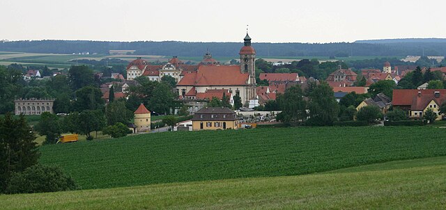
Алесхайм (Alesheim, Alesheim)

 Hiking in Алесхайм
Alesheim, located in Bavaria, Germany, is surrounded by picturesque landscapes that are perfect for hiking enthusiasts. While it may not be as widely known as some of the larger national parks in Germany, it offers several beautiful trails and a chance to experience the serene nature of the region. Here are some notable aspects of hiking in the area:
Trails and Routes
-
Local Trails: Alesheim has several marked walking and hiking paths that allow you to explore the surrounding countryside, including forested areas, fields, and small hills.
-
Long-Distance Routes: A bit further from Alesheim, you can access parts of longer-distance hiking routes such as the Franconian Jura or the Altmühltal Nature Park, both known for their stunning landscapes and geological features.
-
Scenic Views: Many trails offer opportunities to see local wildlife and enjoy vistas of the surrounding Bavarian countryside.
Hiking Tips
- Weather: Check the weather forecast before heading out. Bavarian weather can change rapidly, so being prepared is key.
- Footwear: Wear sturdy hiking boots that provide good support, especially if you plan to tackle more rugged terrain.
- Maps and Navigation: While many trails are marked, carrying a map or using a hiking app can help you navigate the area more effectively.
- Safety: Always let someone know your hiking plans, carry plenty of water, and consider bringing snacks for energy.
Best Times to Hike
- Spring and Fall: These seasons are particularly nice for hiking in Bavaria due to moderate temperatures and beautiful foliage.
Nearby Attractions
- Historical Sites: After a day of hiking, you might want to explore some local historical sites in Alesheim or nearby towns, including traditional Bavarian architecture and castles.
Conclusion
While Alesheim may not be a prominent hiking destination, it offers a relaxing and scenic atmosphere for those looking to enjoy nature in pleasant surroundings. Make sure to explore the local trails and enjoy the natural beauty that Bavaria has to offer!
- Страна:

- Почтовый код: 91793
- Телефонный код: 09146
- Код автомобильного номера: WUG
- Координаты: 49° 3' 0" N, 10° 52' 0" E


- GPS треки (wikiloc): [Ссылка]
- Высота над уровнем моря: 427 м m
- Площадь: 20.45 кв.км
- Население: 949
- Веб сайт: http://www.alesheim.de
- Википедия русская: wiki(ru)
- Википедия английская: wiki(en)
- Википедия национальная: wiki(de)
- Хранилище Wikidata: Wikidata: Q550719
- Катеория в википедии: [Ссылка]
- код Freebase: [/m/02q93p9]
- код GeoNames: Альт: [2958557]
- код VIAF: Альт: [236107837]
- ID отношения в OpenStreetMap: [1015138]
- код GND: Альт: [4505635-3]
- код TGN: [7060199]
- код Historical Gazetteer: [ALEEIMJN59KB]
- Bavarikon ID: [ODB_A00000198]
- идентификатор муниципалитетов в Германии: 09577113
Включает регионы:

Ленгенфельд
Hiking in Ленгенфельд
Lengenfeld, located near Alesheim in Germany, offers a variety of hiking opportunities for both beginners and experienced hikers. The landscape in this region is characterized by rolling hills, dotted with picturesque farmland, dense forests, and charming villages....
- Страна:
- Почтовый код: 91793
- Телефонный код: 09146
- Координаты: 49° 0' 20" N, 10° 52' 18" E
- GPS треки (wikiloc): [Ссылка]
Störzelbach
Hiking in Störzelbach
Störzelbach, located near Alesheim in Bavaria, Germany, offers a picturesque setting for hiking enthusiasts. The area is characterized by its scenic landscapes, rolling hills, and lush forests. Here are some key aspects of hiking in this region:...
- Страна:
- Почтовый код: 91793
- Телефонный код: 09146
- Координаты: 49° 3' 11" N, 10° 53' 19" E
- GPS треки (wikiloc): [Ссылка]
- Высота над уровнем моря: 440 м m

Trommetsheim
Hiking in Trommetsheim
Trommetsheim, situated in Germany, offers various hiking opportunities that allow you to immerse yourself in the beautiful landscapes of the region. Here are some highlights and recommendations for hiking in this area:...
- Страна:
- Почтовый код: 91793
- Телефонный код: 09146
- Координаты: 49° 1' 41" N, 10° 52' 0" E
- GPS треки (wikiloc): [Ссылка]
- Высота над уровнем моря: 416 м m

Wachenhofen
Hiking in Wachenhofen
Wachenhofen, while not as widely recognized as other hiking destinations in Germany, can still offer some charming trails and natural beauty for outdoor enthusiasts. Here are a few things to consider when hiking in and around Wachenhofen:...
- Страна:
- Почтовый код: 91793
- Телефонный код: 09834
- Координаты: 49° 3' 13" N, 10° 50' 37" E
- GPS треки (wikiloc): [Ссылка]
- Высота над уровнем моря: 434 м m
Граничит с регионами:


Тройхтлинген
Hiking in Тройхтлинген
Treuchtlingen is a lovely town located in the Franconia region of Bavaria, Germany, and offers a variety of opportunities for hiking enthusiasts. Nestled in the picturesque terrain of the Jura Mountains, the area is characterized by its scenic landscapes, rich flora and fauna, and numerous marked hiking trails....
- Страна:
- Почтовый код: 91757
- Телефонный код: 09142
- Координаты: 48° 57' 19" N, 10° 54' 34" E
- GPS треки (wikiloc): [Ссылка]
- Высота над уровнем моря: 412 м m
- Площадь: 103 кв.км
- Население: 12781
- Веб сайт: [Ссылка]


Вайсенбург
Hiking in Вайсенбург
Weißenburg in Bayern, located in the picturesque region of Bavaria, Germany, offers a wonderful variety of hiking opportunities for outdoor enthusiasts. Here are some key points about hiking in this area:...
- Страна:
- Почтовый код: 91781
- Телефонный код: 09141
- Код автомобильного номера: WUG
- Координаты: 49° 1' 50" N, 10° 58' 19" E
- GPS треки (wikiloc): [Ссылка]
- Высота над уровнем моря: 422 м m
- Площадь: 97.55 кв.км
- Население: 17976
- Веб сайт: [Ссылка]

Эллинген
Hiking in Эллинген
Ellingen is a picturesque village located in Bavaria, Germany, known for its beautiful landscapes and historical charm. Hiking in and around Ellingen offers a delightful experience for nature lovers and outdoor enthusiasts. Here are some highlights you can expect when hiking in this area:...
- Страна:
- Почтовый код: 91792
- Телефонный код: 09141
- Код автомобильного номера: WUG
- Координаты: 49° 3' 39" N, 10° 58' 4" E
- GPS треки (wikiloc): [Ссылка]
- Высота над уровнем моря: 395 м m
- Площадь: 31.25 кв.км
- Население: 3638
- Веб сайт: [Ссылка]


Тайленхофен
Hiking in Тайленхофен
Theilenhofen, located in Bavaria, Germany, offers beautiful scenic landscapes that are perfect for hiking enthusiasts. The region features a mix of natural beauty, charming villages, and a rich cultural heritage, making it a great destination for outdoor activities....
- Страна:
- Почтовый код: 91741
- Телефонный код: 09834
- Код автомобильного номера: WUG
- Координаты: 49° 5' 0" N, 10° 51' 0" E
- GPS треки (wikiloc): [Ссылка]
- Высота над уровнем моря: 494 м m
- Площадь: 20.32 кв.км
- Население: 1129
- Веб сайт: [Ссылка]


Майнхайм
Hiking in Майнхайм
Meinheim is a municipality located in the Middle Franconia region of Bavaria, Germany. While it may not be as widely known for hiking as larger national parks or mountainous areas, the region around Meinheim offers a number of picturesque trails that can provide a delightful experience for hikers....
- Страна:
- Почтовый код: 91802
- Телефонный код: 09146
- Код автомобильного номера: WUG
- Координаты: 49° 2' 0" N, 10° 49' 0" E
- GPS треки (wikiloc): [Ссылка]
- Высота над уровнем моря: 433 м m
- Площадь: 16.36 кв.км
- Население: 842
- Веб сайт: [Ссылка]


Маркт-Берольцхайм
Hiking in Маркт-Берольцхайм
Markt Berolzheim, located in Bavaria, Germany, is a picturesque village that offers a range of outdoor activities, including hiking. The region is characterized by its beautiful landscapes, rolling hills, and scenic trails, making it an appealing destination for nature enthusiasts....
- Страна:
- Почтовый код: 91801
- Телефонный код: 09146
- Код автомобильного номера: WUG
- Координаты: 49° 1' 0" N, 10° 51' 0" E
- GPS треки (wikiloc): [Ссылка]
- Высота над уровнем моря: 424 м m
- Площадь: 14.52 кв.км
- Население: 1280
- Веб сайт: [Ссылка]


Диттенхайм
Hiking in Диттенхайм
Dittenheim is a charming village located in Bavaria, Germany, known for its picturesque landscapes and outdoor recreational opportunities. Hiking in and around Dittenheim can be a delightful experience, offering various trails and natural attractions....
- Страна:
- Почтовый код: 91723
- Телефонный код: 09834
- Код автомобильного номера: WUG
- Координаты: 49° 3' 0" N, 10° 48' 0" E
- GPS треки (wikiloc): [Ссылка]
- Высота над уровнем моря: 437 м m
- Площадь: 29.34 кв.км
- Население: 1643
- Веб сайт: [Ссылка]