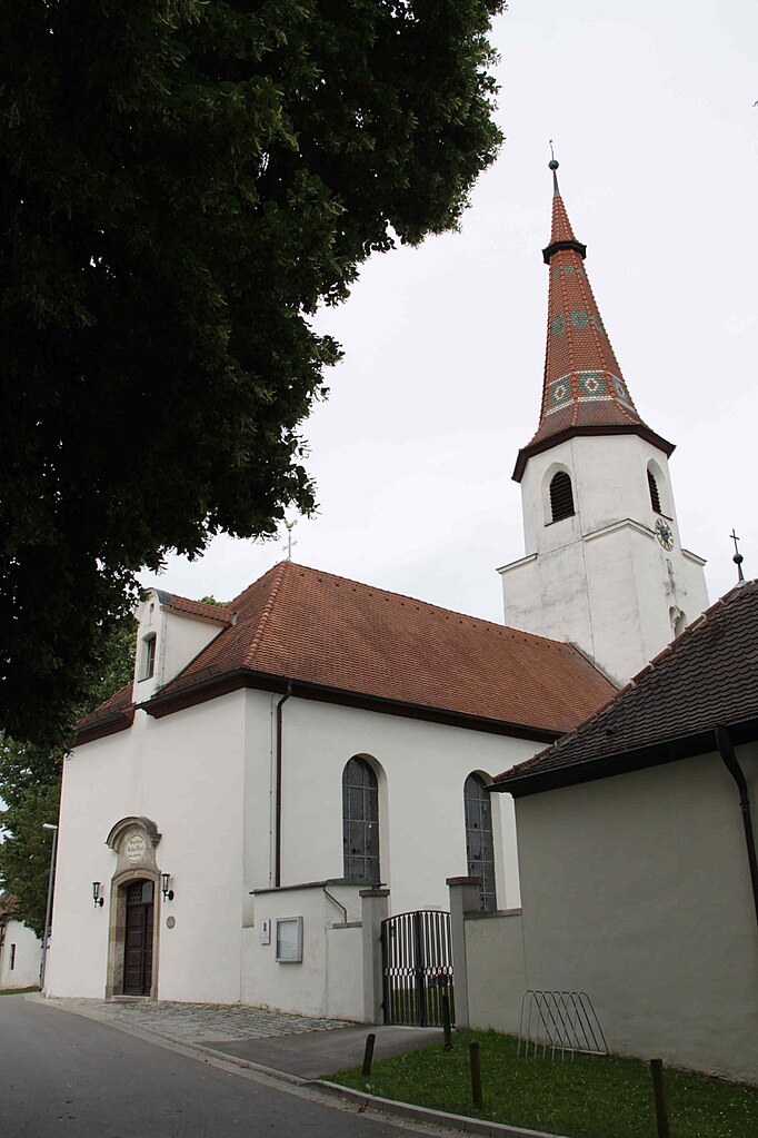
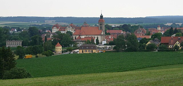
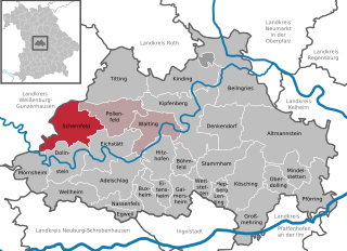
Вайсенбург (Weißenburg in Bayern, Weißenburg in Bayern)

 Hiking in Вайсенбург
Weißenburg in Bayern, located in the picturesque region of Bavaria, Germany, offers a wonderful variety of hiking opportunities for outdoor enthusiasts. Here are some key points about hiking in this area:
Scenic Trails
-
Natural Landscapes: The region around Weißenburg features stunning natural landscapes, including rolling hills, dense forests, and charming fields. The trails often provide beautiful views and peaceful surroundings.
-
Historical Routes: Many hiking paths in and around Weißenburg are intertwined with local history, showcasing landmarks such as ancient ruins, churches, and abandoned castles.
Recommended Hikes
-
Mühlenweg: A popular trail that takes you along the scenic route of old mills. It's perfect for families and those looking for a leisurely hike.
-
Hiking to the Altmühl Valley: This area is part of the Altmühltal Nature Park, known for its striking cliffs, river valleys, and diverse flora and fauna. Trails here can range from easy strolls to more challenging hikes.
-
Part of the Franconian Way of St. James: This famous pilgrimage route passes near Weißenburg, providing an opportunity for a spiritual journey along with beautiful landscapes.
Trail Difficulty
- Variety of Levels: The trails vary in difficulty, from easy walks suitable for beginners and families to more strenuous hikes for seasoned walkers. Always check local trail maps for specific difficulty ratings.
Hiking Tips
- Preparation: Always wear comfortable and suitable hiking shoes, bring enough water, snacks, and a basic first-aid kit.
- Weather Check: Bavaria's weather can change quickly, so check the forecast and dress in layers.
- Leave No Trace: Respect nature by following Leave No Trace principles, ensuring that you pack out whatever you pack in.
Local Attractions
- After a hike, consider exploring Weißenburg’s charming town center with its well-preserved medieval buildings and enjoy local Bavarian cuisine at one of the eateries.
Conclusion
Hiking in Weißenburg in Bayern provides a blend of stunning scenery, rich history, and varied trail options, making it a fantastic destination for hikers of all levels. Whether you're looking for a short walk or a longer trek in nature, you're sure to find something enjoyable in this beautiful region of Bavaria.
- Страна:

- Почтовый код: 91781
- Телефонный код: 09141
- Код автомобильного номера: WUG
- Координаты: 49° 1' 50" N, 10° 58' 19" E


- GPS треки (wikiloc): [Ссылка]
- Высота над уровнем моря: 422 м m
- Площадь: 97.55 кв.км
- Население: 17976
- Веб сайт: https://www.weissenburg.de/
- Википедия русская: wiki(ru)
- Википедия английская: wiki(en)
- Википедия национальная: wiki(de)
- Хранилище Wikidata: Wikidata: Q44500
- Галерея изображений в википедии: [Ссылка]
- Катеория в википедии: [Ссылка]
- код Freebase: [/m/06b3rd]
- код GeoNames: Альт: [2811909]
- код BNF: [11940579b]
- код VIAF: Альт: [146607370]
- ID отношения в OpenStreetMap: [1015141]
- код GND: Альт: [4065243-9]
- идентификатор местоположения ArchINFORM: [9587]
- код LCNAF: Альт: [n82140023]
- код тезауруса PACTOLS: [pcrtoiO9LTm8w4]
- место в MusicBrainz: [d5747142-73c4-465f-b07e-882f600e4566]
- код темы Quora: [Weißenburg-in-Bayern]
- код TGN: [7007577]
- код Historical Gazetteer: [WEIERNJN59LA]
- EMLO location ID: [51a92389-7ec2-43a9-9e03-6a5f24950625]
- Bavarikon ID: [ODB_A00000222]
- код NKC: [ge931105]
- идентификатор муниципалитетов в Германии: 09577177
Включает регионы:

Dettenheim
Hiking in Dettenheim
Dettenheim, located near Weißenburg in the Bavarian region of Germany, is an area that offers a variety of outdoor activities including hiking. The region is characterized by beautiful landscapes, historical sites, and trails that cater to different levels of hiking experience. Here are some key points to consider if you're planning to hike in Dettenheim:...
- Страна:
- Почтовый код: 91781
- Телефонный код: 09142
- Координаты: 48° 59' 14" N, 10° 56' 47" E
- GPS треки (wikiloc): [Ссылка]
- Высота над уровнем моря: 435 м m
Potschmühle
Hiking in Potschmühle
Potschmühle is a picturesque area located in Germany, known for its scenic landscapes and beautiful trails. If you're planning a hiking trip there, here are some key points to consider:...
- Страна:
- Почтовый код: 91781
- Телефонный код: 09141
- Координаты: 48° 58' 46" N, 11° 0' 43" E
- GPS треки (wikiloc): [Ссылка]
- Высота над уровнем моря: 455 м m
Schleifer am Berg
Hiking in Schleifer am Berg
Schleifer am Berg is a picturesque location that often attracts outdoor enthusiasts, primarily for its beautiful landscapes and hiking opportunities. Here’s an overview of what you can expect when hiking in this area:...
- Страна:
- Почтовый код: 91781
- Телефонный код: 09141
- Координаты: 49° 1' 13" N, 11° 0' 15" E
- GPS треки (wikiloc): [Ссылка]
- Высота над уровнем моря: 530 м m
Stadelhof
Hiking in Stadelhof
Stadelhof is a small district located near Weißenburg in Bayern, Germany, and offers a wonderful backdrop for hiking enthusiasts. The surrounding areas are characterized by beautiful landscapes, including forests, rolling hills, and historical landmarks....
- Страна:
- Почтовый код: 91781
- Телефонный код: 09141
- Координаты: 48° 59' 58" N, 10° 57' 30" E
- GPS треки (wikiloc): [Ссылка]
Laubenthal
Hiking in Laubenthal
Laubenthal, located near Weißenburg in Bavaria, Germany, offers a scenic setting for hikers interested in exploring the natural beauty of the region. The area is characterized by lush green landscapes, rolling hills, and historical sites that make for a rich hiking experience....
- Страна:
- Почтовый код: 91781
- Телефонный код: 09141
- Координаты: 48° 58' 41" N, 11° 2' 57" E
- GPS треки (wikiloc): [Ссылка]
- Высота над уровнем моря: 480 м m
Markhof
Hiking in Markhof
Markhof, a district of Weißenburg in Bavaria, Germany, offers a range of hiking opportunities for outdoor enthusiasts. The region is characterized by its picturesque landscapes, historical sites, and scenic trails. Here are some key points about hiking in this area:...
- Страна:
- Почтовый код: 91781
- Телефонный код: 09141
- Координаты: 48° 59' 58" N, 10° 57' 4" E
- GPS треки (wikiloc): [Ссылка]
- Высота над уровнем моря: 430 м m
Weißenhof
Hiking in Weißenhof
Weißenhof, located in the town of Weißenburg in Bavaria, Germany, offers several opportunities for hiking, especially given its picturesque surroundings and historical significance. The area is known for its beautiful landscapes, including wooded areas, rolling hills, and scenic views of the surrounding countryside....
- Страна:
- Почтовый код: 91781
- Телефонный код: 09141
- Координаты: 49° 1' 56" N, 10° 56' 48" E
- GPS треки (wikiloc): [Ссылка]
- Высота над уровнем моря: 420 м m

Вюльцбург
Hiking in Вюльцбург
Wülzburg, a notable historical site in Bavaria, Germany, is not just known for its impressive fortifications but also for its scenic hiking opportunities. Here's an overview of what you might expect when hiking in and around Wülzburg:...
- Страна:
- Координаты: 49° 1' 32" N, 11° 0' 19" E
- GPS треки (wikiloc): [Ссылка]
- Высота над уровнем моря: 631 м m
- Площадь: 73000 кв.км
Niederhofen
Hiking in Niederhofen
Niederhofen, located near Weißenburg in Bavaria, Germany, offers a charming experience for hikers looking to explore the scenic Bavarian countryside. The area is characterized by rolling hills, lush forests, and picturesque landscapes, making it an ideal destination for outdoor enthusiasts....
- Страна:
- Почтовый код: 91781
- Телефонный код: 09141
- Координаты: 49° 2' 28" N, 11° 1' 43" E
- GPS треки (wikiloc): [Ссылка]
- Высота над уровнем моря: 465 м m
Emetzheim
Hiking in Emetzheim
Emetzheim is a small village located in Bavaria, Germany, known for its beautiful landscapes and access to hiking trails. While it's not as widely recognized as some of the larger hiking destinations, Emetzheim offers a peaceful retreat for hikers looking to explore the scenic countryside....
- Страна:
- Почтовый код: 91781
- Телефонный код: 09141
- Координаты: 49° 0' 58" N, 10° 56' 6" E
- GPS треки (wikiloc): [Ссылка]
- Высота над уровнем моря: 428 м m

Gänswirthshaus
Hiking in Gänswirthshaus
Gänswirthshaus is not a widely recognized hiking destination, so it's possible that it may refer to a local area or specific hut in the German-speaking regions, particularly in the Alps or surrounding areas. However, if you're interested in general hiking in the region, here's what you can typically expect when hiking in similar Alpine areas:...
- Страна:
- Почтовый код: 91781
- Телефонный код: 09141
- Координаты: 49° 2' 12" N, 11° 0' 54" E
- GPS треки (wikiloc): [Ссылка]
- Высота над уровнем моря: 460 м m
Haardt
Hiking in Haardt
Hiking in the Haardt region near Weißenburg offers a beautiful blend of nature, history, and breathtaking landscapes. The Haardt mountains, which are part of the larger Palatinate Forest, provide numerous trails suitable for hikers of all levels. Here are some highlights:...
- Страна:
- Почтовый код: 91781
- Телефонный код: 09141
- Координаты: 48° 59' 35" N, 10° 59' 11" E
- GPS треки (wikiloc): [Ссылка]
- Высота над уровнем моря: 553 м m
Hagenbuch
Hiking in Hagenbuch
Hagenbuch, located near Weißenburg in Bavaria, Germany, offers a lovely environment for hiking enthusiasts. The region is characterized by picturesque landscapes, including hills, forests, and agricultural fields, which provide a perfect backdrop for various hiking trails....
- Страна:
- Почтовый код: 91781
- Телефонный код: 09141
- Координаты: 49° 2' 35" N, 10° 59' 0" E
- GPS треки (wikiloc): [Ссылка]
- Высота над уровнем моря: 420 м m

Hattenhof
Hiking in Hattenhof
Hattenhof, located near Weißenburg in Bavaria, Germany, is surrounded by beautiful countryside, rolling hills, and a network of scenic trails that make it a great destination for hiking enthusiasts. Here are some key points to consider when hiking in this area:...
- Страна:
- Почтовый код: 91781
- Телефонный код: 09141
- Координаты: 49° 2' 2" N, 10° 56' 28" E
- GPS треки (wikiloc): [Ссылка]
- Высота над уровнем моря: 430 м m
Heuberg
Hiking in Heuberg
Heuberg, located near Weißenburg in Bavaria, Germany, offers a variety of hiking opportunities that cater to different skill levels, from leisurely walks to more challenging treks. The area is known for its scenic beauty, lush landscapes, and historical significance....
- Страна:
- Почтовый код: 91781
- Телефонный код: 09141
- Координаты: 48° 59' 24" N, 11° 0' 25" E
- GPS треки (wikiloc): [Ссылка]
- Высота над уровнем моря: 533 м m

Holzingen
Hiking in Holzingen
Holzingen is a charming village in Germany that offers a variety of hiking opportunities for outdoor enthusiasts. The region is known for its scenic landscapes, rolling hills, and beautiful natural surroundings, making it an excellent spot for both casual walkers and experienced hikers....
- Страна:
- Почтовый код: 91781
- Телефонный код: 09141
- Координаты: 49° 1' 18" N, 10° 55' 24" E
- GPS треки (wikiloc): [Ссылка]
- Высота над уровнем моря: 421 м m

Kattenhochstatt
Hiking in Kattenhochstatt
Kattenhochstatt, located in Bavaria, Germany, offers a serene environment for hiking enthusiasts. The region is characterized by gentle rolling hills, lush forests, and scenic trails that provide an excellent backdrop for outdoor activities. Here are some details about hiking in Kattenhochstatt:...
- Страна:
- Почтовый код: 91781
- Телефонный код: 09141
- Координаты: 49° 1' 29" N, 10° 54' 17" E
- GPS треки (wikiloc): [Ссылка]
- Высота над уровнем моря: 425 м m
Kehl
Hiking in Kehl
Kehl, located near the Rhine River in Germany, offers a scenic backdrop for hiking enthusiasts. While Kehl itself is not a mountainous region, it serves as a gateway to various beautiful trails in the nearby Black Forest and Alsace region in France. Here are some key points about hiking in and around Kehl:...
- Страна:
- Почтовый код: 91781
- Телефонный код: 09141
- Координаты: 49° 1' 47" N, 11° 0' 40" E
- GPS треки (wikiloc): [Ссылка]
- Высота над уровнем моря: 523 м m
Oberhochstatt
Hiking in Oberhochstatt
Oberhochstatt, located in Germany, offers a variety of hiking opportunities for outdoor enthusiasts. Nestled in a scenic region, it typically features beautiful landscapes, rolling hills, and well-marked trails suitable for various skill levels....
- Страна:
- Почтовый код: 91781
- Телефонный код: 09141
- Координаты: 49° 1' 48" N, 11° 2' 53" E
- GPS треки (wikiloc): [Ссылка]
- Высота над уровнем моря: 578 м m
Rothenstein
Hiking in Rothenstein
Rothenstein, located in the Weißenburg area of Bavaria, Germany, offers various hiking opportunities that showcase the natural beauty and charming landscapes of the region. Here are some key points about hiking in this area:...
- Страна:
- Почтовый код: 91781
- Телефонный код: 09149
- Координаты: 48° 57' 55" N, 11° 3' 30" E
- GPS треки (wikiloc): [Ссылка]
- Высота над уровнем моря: 517 м m
Schmalwiesen
Hiking in Schmalwiesen
Schmalwiesen is a beautiful area located in the Black Forest region of Germany. It offers various hiking opportunities that cater to different skill levels and preferences. Here are some highlights and tips for hiking in Schmalwiesen:...
- Страна:
- Почтовый код: 91781
- Телефонный код: 09141
- Координаты: 49° 2' 46" N, 10° 57' 5" E
- GPS треки (wikiloc): [Ссылка]
- Высота над уровнем моря: 430 м m
Suffersheim
Hiking in Suffersheim
Suffersheim appears to be a lesser-known location, and there may not be extensive hiking information readily available about it. However, if you are considering hiking in the surrounding area, I can provide some general tips and information to help you plan your adventure....
- Страна:
- Почтовый код: 91781
- Телефонный код: 09149
- Координаты: 48° 58' 58" N, 11° 1' 8" E
- GPS треки (wikiloc): [Ссылка]
- Высота над уровнем моря: 465 м m
Weimersheim
Hiking in Weimersheim
Weimersheim, part of Weißenburg in Bayern in Bavaria, Germany, is surrounded by beautiful landscapes that are great for hiking enthusiasts. The region offers a mix of lush forests, rolling hills, and scenic views, making it an attractive destination for outdoor activities....
- Страна:
- Почтовый код: 91781
- Телефонный код: 09141
- Координаты: 49° 2' 30" N, 10° 55' 11" E
- GPS треки (wikiloc): [Ссылка]
- Высота над уровнем моря: 449 м m
Hammermühle
Hiking in Hammermühle
Hammermühle, located near Weißenburg in Bavaria, Germany, offers a scenic hiking experience characterized by beautiful landscapes, historical sites, and natural beauty. The surrounding area is known for its diverse terrain, which includes rolling hills, woodlands, and the Altmühl River nearby. Here are some key points about hiking in Hammermühle:...
- Страна:
- Почтовый код: 91781
- Телефонный код: 09141
- Координаты: 48° 58' 38" N, 11° 0' 18" E
- GPS треки (wikiloc): [Ссылка]
- Высота над уровнем моря: 450 м m
Граничит с регионами:


Тройхтлинген
Hiking in Тройхтлинген
Treuchtlingen is a lovely town located in the Franconia region of Bavaria, Germany, and offers a variety of opportunities for hiking enthusiasts. Nestled in the picturesque terrain of the Jura Mountains, the area is characterized by its scenic landscapes, rich flora and fauna, and numerous marked hiking trails....
- Страна:
- Почтовый код: 91757
- Телефонный код: 09142
- Координаты: 48° 57' 19" N, 10° 54' 34" E
- GPS треки (wikiloc): [Ссылка]
- Высота над уровнем моря: 412 м m
- Площадь: 103 кв.км
- Население: 12781
- Веб сайт: [Ссылка]


Паппенхайм
Hiking in Паппенхайм
Pappenheim, located in the picturesque region of Bavaria, Germany, offers a variety of hiking opportunities that cater to different skill levels. The area is known for its beautiful landscapes, rich history, and well-marked trails....
- Страна:
- Почтовый код: 91788
- Телефонный код: 09143
- Код автомобильного номера: WUG
- Координаты: 48° 56' 5" N, 10° 58' 28" E
- GPS треки (wikiloc): [Ссылка]
- Высота над уровнем моря: 405 м m
- Площадь: 64.32 кв.км
- Население: 4049
- Веб сайт: [Ссылка]

Эллинген
Hiking in Эллинген
Ellingen is a picturesque village located in Bavaria, Germany, known for its beautiful landscapes and historical charm. Hiking in and around Ellingen offers a delightful experience for nature lovers and outdoor enthusiasts. Here are some highlights you can expect when hiking in this area:...
- Страна:
- Почтовый код: 91792
- Телефонный код: 09141
- Код автомобильного номера: WUG
- Координаты: 49° 3' 39" N, 10° 58' 4" E
- GPS треки (wikiloc): [Ссылка]
- Высота над уровнем моря: 395 м m
- Площадь: 31.25 кв.км
- Население: 3638
- Веб сайт: [Ссылка]


Хёттинген
Hiking in Хёттинген
Höttingen is a small village in Bavaria, Germany, situated near the Altmühl River and surrounded by picturesque landscapes that make it an appealing place for hiking and outdoor activities. While it might not be as widely known as larger towns, it offers some beautiful trails and scenery typical of the region....
- Страна:
- Почтовый код: 91798
- Телефонный код: 09141
- Код автомобильного номера: WUG
- Координаты: 49° 4' 0" N, 11° 1' 0" E
- GPS треки (wikiloc): [Ссылка]
- Высота над уровнем моря: 430 м m
- Площадь: 19.26 кв.км
- Население: 1148
- Веб сайт: [Ссылка]


Бургзалах
Hiking in Бургзалах
Burgsalach is a picturesque area located in Germany, often noted for its beautiful landscapes and hiking opportunities, especially surrounded by nature reserves and scenic trails. While I don't have specific updated trail information, here are some general insights and tips for hiking in that region:...
- Страна:
- Почтовый код: 91790
- Телефонный код: 09147
- Код автомобильного номера: WUG
- Координаты: 49° 2' 0" N, 11° 6' 0" E
- GPS треки (wikiloc): [Ссылка]
- Высота над уровнем моря: 583 м m
- Площадь: 19.31 кв.км
- Население: 1143
- Веб сайт: [Ссылка]


Эттенштат
Hiking in Эттенштат
Ettenstatt is a charming village located in the Altmühl Valley in Bavaria, Germany. This region is well-known for its beautiful landscapes, rich history, and diverse outdoor activities, including hiking....
- Страна:
- Почтовый код: 91796
- Телефонный код: 09148
- Код автомобильного номера: WUG
- Координаты: 49° 4' 59" N, 11° 3' 0" E
- GPS треки (wikiloc): [Ссылка]
- Высота над уровнем моря: 440 м m
- Площадь: 15.84 кв.км
- Население: 846
- Веб сайт: [Ссылка]


Берген
- коммуна в Баварии (Средняя Франкония)
Hiking in Берген
Bergen, located in the Middle Franconia region of Germany, offers a variety of hiking opportunities for all levels of experience. The picturesque landscape is characterized by rolling hills, wooded areas, and charming rural vistas, making it an ideal spot for hiking enthusiasts....
- Страна:
- Почтовый код: 91790
- Телефонный код: 09148; 09147
- Код автомобильного номера: WUG
- Координаты: 49° 5' 0" N, 11° 7' 0" E
- GPS треки (wikiloc): [Ссылка]
- Высота над уровнем моря: 540 м m
- Площадь: 19.91 кв.км
- Население: 1082
- Веб сайт: [Ссылка]


Райтенбух
Hiking in Райтенбух
Raitenbuch is a picturesque village located in Bavaria, Germany, near the borders of the scenic Allgäu region. Hiking in and around Raitenbuch offers a range of trails, suitable for various skill levels, showcasing the natural beauty of the Bavarian countryside, including rolling hills, lush forests, and stunning views of the Alps....
- Страна:
- Почтовый код: 91790
- Телефонный код: 09147
- Код автомобильного номера: WUG
- Координаты: 49° 0' 53" N, 11° 7' 35" E
- GPS треки (wikiloc): [Ссылка]
- Высота над уровнем моря: 559 м m
- Площадь: 38.2 кв.км
- Население: 1206
- Веб сайт: [Ссылка]


Алесхайм
Hiking in Алесхайм
Alesheim, located in Bavaria, Germany, is surrounded by picturesque landscapes that are perfect for hiking enthusiasts. While it may not be as widely known as some of the larger national parks in Germany, it offers several beautiful trails and a chance to experience the serene nature of the region. Here are some notable aspects of hiking in the area:...
- Страна:
- Почтовый код: 91793
- Телефонный код: 09146
- Код автомобильного номера: WUG
- Координаты: 49° 3' 0" N, 10° 52' 0" E
- GPS треки (wikiloc): [Ссылка]
- Высота над уровнем моря: 427 м m
- Площадь: 20.45 кв.км
- Население: 949
- Веб сайт: [Ссылка]

Шернфельд
Hiking in Шернфельд
Schernfeld, located in Bavaria, Germany, is a charming area surrounded by picturesque landscapes, making it a great location for hiking enthusiasts. The region offers a combination of scenic routes that cater to various skill levels, from leisurely walks to more challenging trails....
- Страна:
- Почтовый код: 85132
- Телефонный код: 08422; 08421
- Код автомобильного номера: EI
- Координаты: 48° 54' 0" N, 11° 6' 0" E
- GPS треки (wikiloc): [Ссылка]
- Высота над уровнем моря: 548 м m
- Площадь: 52.22 кв.км
- Население: 3181
- Веб сайт: [Ссылка]