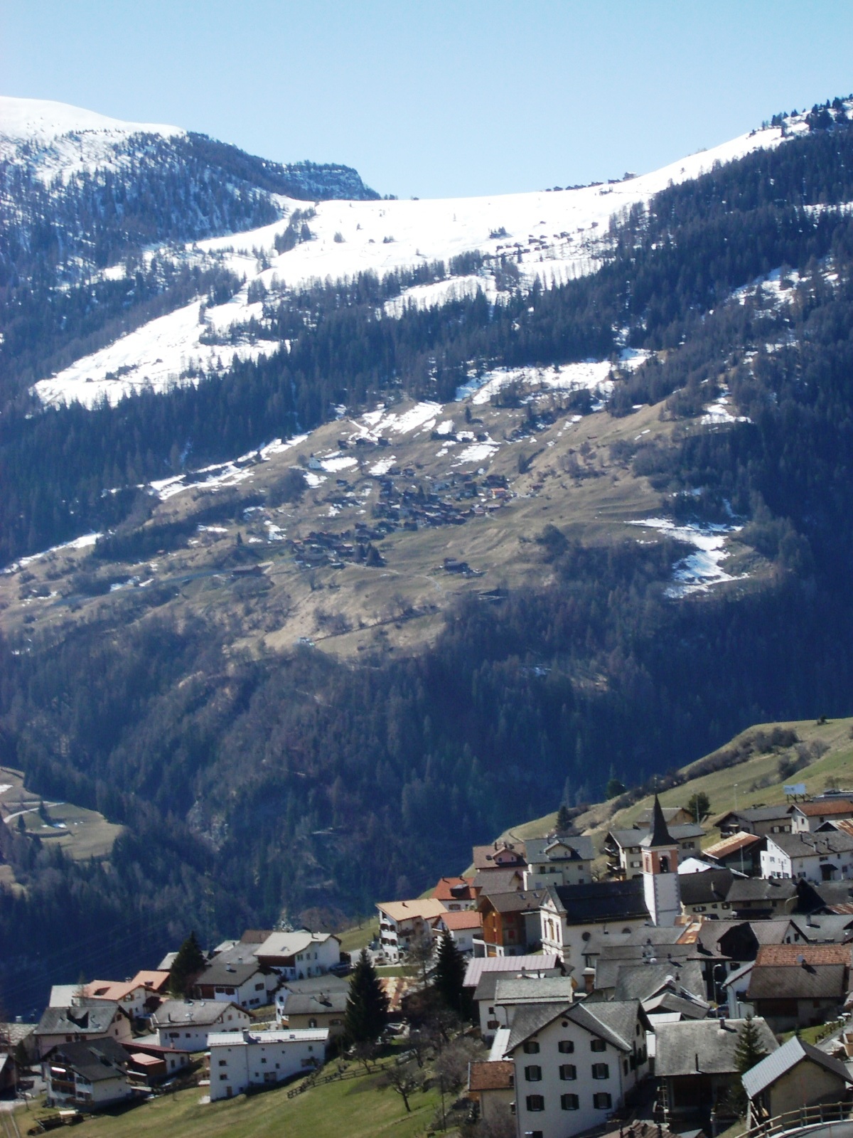
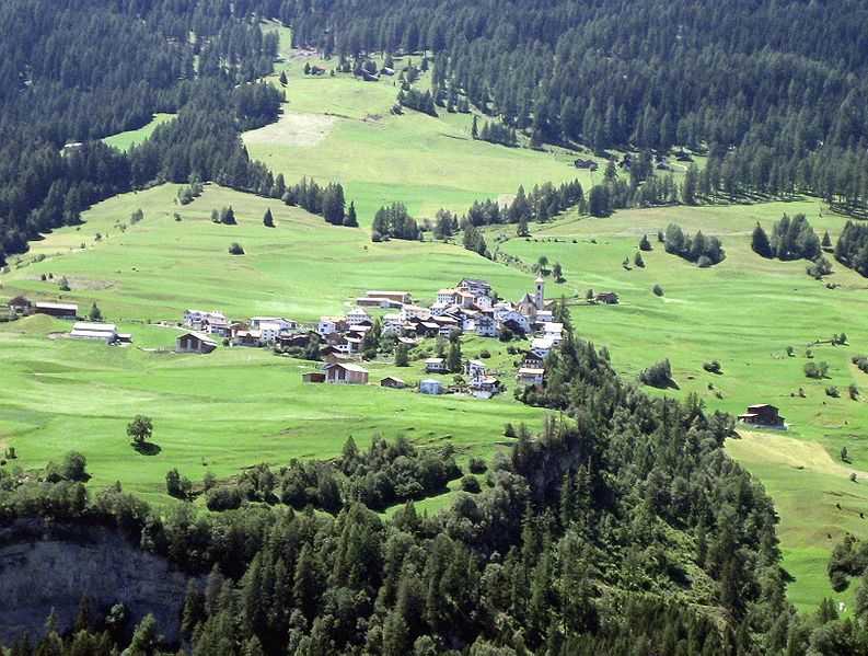
Альвашайн (Alvaschein, Alvaschein)

 Hiking in Альвашайн
Alvaschein is a picturesque village located in the canton of Graubünden in Switzerland, surrounded by stunning alpine landscapes. It serves as an excellent base for hiking enthusiasts looking to explore the natural beauty of the region.
Hiking Trails
-
Local Trails: Alvaschein itself has several well-marked trails that meander through lush meadows, dense forests, and offer breathtaking views of the surrounding mountains. These local trails can vary in difficulty, making them suitable for beginners as well as more experienced hikers.
-
Panoramaweg: This is a popular trail that provides panoramic views of the landscape. It often leads to higher elevations where you can see the picturesque valleys and other mountain peaks surrounding Alvaschein.
-
Dolomitenweg: This scenic trail takes hikers along the dramatic landscapes of the region and is characterized by its unique rock formations. It’s recommended for those looking for a moderate challenge.
-
Cultural Routes: Some hiking paths also include historical or cultural elements, allowing hikers to combine physical activity with learning more about the local heritage.
Wildlife and Flora
While hiking in the area, you may encounter diverse flora and fauna typical of the Swiss Alps. Keep an eye out for local wildlife, including various species of birds, deer, and perhaps even chamois at higher altitudes.
Essential Tips
-
Gear: Ensure that you wear appropriate hiking boots and clothing suitable for alpine conditions. Weather can change rapidly, so layers are recommended.
-
Navigation: Use hiking maps or GPS apps to navigate the trails, as some paths may not be well-marked.
-
Hydration and Snacks: Carry enough water and snacks to keep your energy levels up during your hike.
-
Safety: Inform someone about your hiking plans, especially if you’re venturing onto less traveled paths. And always be mindful of your skill level and physical condition.
Best Time to Hike
The ideal time for hiking around Alvaschein is typically from late spring to early autumn (May to October), when the weather is milder, and the trails are generally clear of snow.
Accessibility
Alvaschein is accessible by public transportation, and there are various accommodations available for hikers looking to extend their stay.
Overall, hiking in Alvaschein offers a unique experience for nature lovers and adventurers alike, combining physical activity with the chance to immerse oneself in the breathtaking beauty of the Swiss Alps.
- Страна:

- Почтовый код: 7451
- Телефонный код: 081
- Код автомобильного номера: GR
- Координаты: 46° 39' 59" N, 9° 32' 59" E


- GPS треки (wikiloc): [Ссылка]
- Высота над уровнем моря: 1001 м m
- Площадь: 4.08 кв.км
- Веб сайт: http://www.alvaschein.ch
- Википедия русская: wiki(ru)
- Википедия английская: wiki(en)
- Википедия национальная: wiki(de)
- Хранилище Wikidata: Wikidata: Q64319
- Катеория в википедии: [Ссылка]
- код Freebase: [/m/0dxwbx]
- код GeoNames: Альт: [2661763]
- код VIAF: Альт: [244359648]
- идентификатор местоположения ArchINFORM: [5341]
- идентификатор HDS: [1409]
- код швейцарского муниципалитета: [3501]
Граничит с регионами:


Тифенкастель
Hiking in Тифенкастель
Tiefencastel is a small village located in the beautiful region of Graubünden in Switzerland, known for its stunning landscapes and excellent hiking opportunities. Here’s an overview of what to expect when hiking in and around Tiefencastel:...
- Страна:
- Почтовый код: 7450
- Телефонный код: 081
- Код автомобильного номера: GR
- Координаты: 46° 38' 42" N, 9° 36' 47" E
- GPS треки (wikiloc): [Ссылка]
- Высота над уровнем моря: 1716 м m
- Площадь: 14.85 кв.км
- Веб сайт: [Ссылка]

Вац
- коммуна в кантоне Граубюнден (Швейцария)
Hiking in Вац
Vaz Obervaz, also known simply as Vaz, is a charming municipality located in the Grisons (Graubünden) region of Switzerland. It's a great destination for hiking enthusiasts due to its stunning landscapes, diverse trails, and access to the surrounding mountains....
- Страна:
- Почтовый код: 7082
- Телефонный код: 081
- Код автомобильного номера: GR
- Координаты: 46° 42' 59" N, 9° 33' 0" E
- GPS треки (wikiloc): [Ссылка]
- Высота над уровнем моря: 1300 м m
- Площадь: 42.51 кв.км
- Население: 2630
- Веб сайт: [Ссылка]


Бриенц-Бринцаульс
Hiking in Бриенц-Бринцаульс
Brienz-Brinzauls is a beautiful region in Switzerland known for its stunning landscapes, picturesque villages, and excellent hiking trails. Located in the Graubünden canton, it offers a mix of natural beauty, traditional Alpine architecture, and a variety of outdoor activities....
- Страна:
- Почтовый код: 7084
- Телефонный код: 081
- Код автомобильного номера: GR
- Координаты: 46° 40' 0" N, 9° 35' 59" E
- GPS треки (wikiloc): [Ссылка]
- Высота над уровнем моря: 1144 м m
- Площадь: 13.37 кв.км
- Веб сайт: [Ссылка]


Ланч-Ленц
Hiking in Ланч-Ленц
Lantsch-Lenz, a picturesque village in the Swiss Alps, offers a fantastic range of hiking opportunities for outdoor enthusiasts. Located in the canton of Graubünden, it is surrounded by stunning landscapes, including lush valleys, alpine meadows, and towering peaks, making it an ideal destination for hiking....
- Страна:
- Почтовый код: 7083
- Телефонный код: 081
- Код автомобильного номера: GR
- Координаты: 46° 42' 25" N, 9° 34' 46" E
- GPS треки (wikiloc): [Ссылка]
- Высота над уровнем моря: 2130 м m
- Площадь: 21.81 кв.км
- Население: 511
- Веб сайт: [Ссылка]

Штирва
Hiking in Штирва
Stierva, a picturesque village located in the heart of the Swiss Alps, offers a stunning array of hiking opportunities for outdoor enthusiasts. Nestled within the Graubünden region, Stierva is known for its breathtaking landscapes, diverse terrain, and rich natural beauty. Here are some key points to consider when hiking in and around Stierva:...
- Страна:
- Почтовый код: 7459
- Телефонный код: 081
- Код автомобильного номера: GR
- Координаты: 46° 38' 59" N, 9° 32' 0" E
- GPS треки (wikiloc): [Ссылка]
- Высота над уровнем моря: 1375 м m
- Площадь: 10.56 кв.км
- Веб сайт: [Ссылка]