Amondans (Amondans)

- коммуна во Франции
 Hiking in Amondans
It appears there might be a spelling error or misunderstanding regarding "Amondans." If you're referring to a specific location, could you please clarify the name? It could be a lesser-known area or perhaps a local term.
However, if you meant a region or national park that is famous for hiking, I can certainly provide information on popular hiking destinations, trail recommendations, safety tips, and more. Just let me know!
- Страна:

- Почтовый код: 25330
- Координаты: 47° 4' 8" N, 6° 2' 25" E


- GPS треки (wikiloc): [Ссылка]
- Площадь: 5.68 кв.км
- Население: 90
- Википедия английская: wiki(en)
- Википедия национальная: wiki(fr)
- Хранилище Wikidata: Wikidata: Q473971
- Катеория в википедии: [Ссылка]
- код Freebase: [/m/03mgbk5]
- код Freebase: [/m/03mgbk5]
- код GeoNames: Альт: [6447809]
- код GeoNames: Альт: [6447809]
- номер SIREN: [212500177]
- номер SIREN: [212500177]
- код BNF: [15252243j]
- код BNF: [15252243j]
- место в MusicBrainz: [9c4cc13b-d17f-444f-aac6-bba0efd11700]
- место в MusicBrainz: [9c4cc13b-d17f-444f-aac6-bba0efd11700]
- код муниципалитета INSEE: 25017
- код муниципалитета INSEE: 25017
Граничит с регионами:

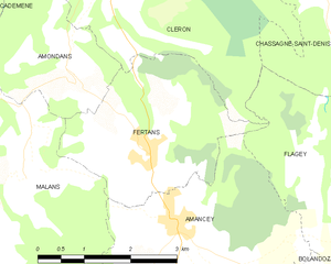
Fertans
- коммуна во Франции
Hiking in Fertans
Fertans is a small village located in the Jura region of France, known for its beautiful landscapes and nature-friendly environment. Hiking in and around Fertans offers a blend of scenic views, diverse terrains, and the tranquility of the Jura mountains. Here are some details to consider:...
- Страна:
- Почтовый код: 25330
- Координаты: 47° 3' 4" N, 6° 3' 48" E
- GPS треки (wikiloc): [Ссылка]
- Площадь: 8.19 кв.км
- Население: 261

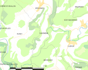
Cademène
- коммуна во Франции
Hiking in Cademène
Cademène is a picturesque area located in the Pyrenees of France, known for its stunning landscapes and extensive hiking trails. Here are some key aspects to know about hiking in Cademène:...
- Страна:
- Почтовый код: 25290
- Координаты: 47° 6' 2" N, 6° 1' 39" E
- GPS треки (wikiloc): [Ссылка]
- Площадь: 3.39 кв.км
- Население: 78
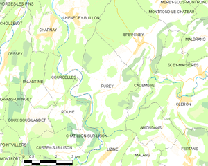
Rurey
- коммуна во Франции
Hiking in Rurey
It seems like there might be a little confusion with the name "Rurey," as it's not widely recognized as a hiking destination. However, if you're referring to a specific area or region, please provide more context or correct the name, and I'll be happy to give you detailed information....
- Страна:
- Почтовый код: 25290
- Координаты: 47° 5' 47" N, 6° 0' 33" E
- GPS треки (wikiloc): [Ссылка]
- Площадь: 14.77 кв.км
- Население: 333


Lizine
- коммуна во Франции
Hiking in Lizine
Lizine is a lesser-known hiking destination, and specific information may vary based on local trails and conditions. However, if you’re looking to explore an area like Lizine, here are some general tips and information you might find useful for hiking in any location:...
- Страна:
- Почтовый код: 25330
- Координаты: 47° 3' 23" N, 5° 59' 39" E
- GPS треки (wikiloc): [Ссылка]
- Площадь: 7.33 кв.км
- Население: 82


Malans
Hiking in Malans
Malans is a charming village located in the Doubs department of the Bourgogne-Franche-Comté region in eastern France. The area surrounding Malans offers a variety of hiking opportunities, showcasing the natural beauty of the Jura mountains and the Doubs countryside....
- Страна:
- Почтовый код: 25330
- Координаты: 47° 2' 52" N, 6° 1' 51" E
- GPS треки (wikiloc): [Ссылка]
- Высота над уровнем моря: 580 м m
- Площадь: 10.49 кв.км
- Население: 173
- Веб сайт: [Ссылка]


Cléron
- коммуна во Франции
Hiking in Cléron
Cléron is a charming village located in the Doubs department of the Bourgogne-Franche-Comté region in eastern France. It is known for its beautiful landscapes, rich natural environment, and historical significance, making it a great spot for hiking enthusiasts....
- Страна:
- Почтовый код: 25330
- Координаты: 47° 5' 14" N, 6° 3' 41" E
- GPS треки (wikiloc): [Ссылка]
- Площадь: 14.56 кв.км
- Население: 322