Arbedo-Castione (Arbedo-Castione)

 Hiking in Arbedo-Castione
Arbedo-Castione is a picturesque area located in the Canton of Ticino, Switzerland. It's known for its beautiful landscapes, rich history, and a variety of hiking trails suitable for different skill levels. Here are some aspects to consider when hiking in Arbedo-Castione:
Trails
-
Beginner Trails: There are several easy trails suitable for beginners and families. These paths often offer gentle slopes and are well-marked, providing a great opportunity to enjoy nature without too much strain.
-
Intermediate Routes: For those with more hiking experience, there are moderate trails that offer a bit more challenge, including some elevation changes and varied terrain. These routes often provide stunning views of the surrounding mountains and valleys.
-
Advanced Hiking: More experienced hikers can explore challenging trails that may include steeper climbs and rugged terrain. Always ensure you are well-prepared for these hikes, as they often require additional stamina and navigational skills.
Highlights
- Scenic Views: Arbedo-Castione is situated near the Blenio Valley and offers breathtaking views of the surrounding mountains and valleys. Look out for panoramic viewpoints along the trails.
- Cultural Sites: Along some hiking routes, you might encounter historical landmarks or local cultural sites, providing insight into the region’s history and heritage.
- Lakes and Rivers: The area may provide access to lakes and rivers for beautiful resting spots or opportunities to enjoy some tranquility by the water.
Practical Tips
- Weather Awareness: It’s essential to check the weather condition before heading out, as mountain weather can change rapidly. Always dress in layers and be prepared for rain or cooler temperatures.
- Footwear: Invest in good quality hiking boots that provide support and grip, especially if you are tackling more rugged terrain.
- Hydration and Nutrition: Carry enough water and snacks, as many trails may lack access to facilities. Staying hydrated is crucial for maintaining energy levels.
- Map and GPS: While most trails are marked, it’s a good idea to carry a map or GPS device, particularly for less traveled routes.
Safety
- Let someone know your plans before heading out, especially if you're hiking alone.
- Keep your phone charged and consider bringing a portable charger, as cell service can be spotty in remote areas.
Enjoy the vibrant nature and tranquil atmosphere of Arbedo-Castione during your hike, and always follow Leave No Trace principles to help preserve the beauty of the landscape!
- Страна:

- Телефонный код: 091
- Код автомобильного номера: TI
- Координаты: 46° 13' 0" N, 9° 3' 0" E


- GPS треки (wikiloc): [Ссылка]
- Высота над уровнем моря: 278 м m
- Площадь: 21.52 кв.км
- Население: 5039
- Веб сайт: http://www.arbedocastione.ch
- Википедия английская: wiki(en)
- Википедия национальная: wiki(de)
- Хранилище Wikidata: Wikidata: Q69788
- Катеория в википедии: [Ссылка]
- код Freebase: [/m/0f9rxb]
- код GeoNames: Альт: [2661732]
- код VIAF: Альт: [157092843]
- ID отношения в OpenStreetMap: [1684616]
- код GND: Альт: [4742196-4]
- идентификатор HDS: [2030]
- код швейцарского муниципалитета: [5001]
Граничит с регионами:
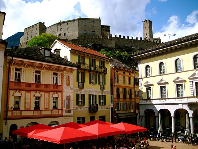
Беллинцона
Hiking in Беллинцона
Bellinzona, located in the Ticino region of Switzerland, is an excellent destination for hiking enthusiasts. The area is renowned for its stunning landscapes, rich history, and a network of well-marked hiking trails that cater to various skill levels. Here are some highlights and recommendations for hiking in and around Bellinzona:...
- Страна:
- Почтовый код: 6500
- Телефонный код: 091
- Код автомобильного номера: TI
- Координаты: 46° 11' 44" N, 9° 1' 26" E
- GPS треки (wikiloc): [Ссылка]
- Высота над уровнем моря: 230 м m
- Площадь: 164.96 кв.км
- Население: 42615
- Веб сайт: [Ссылка]


Lumino
Hiking in Lumino
Lumino is a picturesque village located in the Canton of Ticino, Switzerland, known for its beautiful landscapes and hiking opportunities. The region offers a range of trails suitable for different skill levels, from easy walks to more challenging hikes....
- Страна:
- Почтовый код: 6533
- Телефонный код: 091
- Код автомобильного номера: TI
- Координаты: 46° 14' 18" N, 9° 4' 5" E
- GPS треки (wikiloc): [Ссылка]
- Высота над уровнем моря: 483 м m
- Площадь: 9.92 кв.км
- Население: 1470
- Веб сайт: [Ссылка]

Gnosca
Hiking in Gnosca
Gnosca, a picturesque village located in the Canton of Ticino in Switzerland, offers a variety of hiking opportunities that take advantage of its beautiful natural surroundings. Here are some key points about hiking in Gnosca:...
- Страна:
- Почтовый код: 6525
- Телефонный код: 091
- Код автомобильного номера: TI
- Координаты: 46° 14' 18" N, 9° 0' 14" E
- GPS треки (wikiloc): [Ссылка]
- Высота над уровнем моря: 801 м m
- Площадь: 7.5 кв.км
- Веб сайт: [Ссылка]


Claro
Hiking in Claro
Claro, a picturesque village in the southern part of Switzerland, is nestled in the Ticino region, a gem for hikers and outdoor enthusiasts. The region offers a variety of trails that highlight its stunning landscapes, diverse flora, and charming valleys. Here are some key aspects to consider when hiking in Claro:...
- Страна:
- Почтовый код: 6702
- Телефонный код: 091
- Код автомобильного номера: TI
- Координаты: 46° 15' 58" N, 9° 2' 12" E
- GPS треки (wikiloc): [Ссылка]
- Высота над уровнем моря: 989 м m
- Площадь: 21.22 кв.км
- Веб сайт: [Ссылка]

Гордуно
- коммуна в Швейцарии
Hiking in Гордуно
Gorduno, located near the region of Ticino in Switzerland, offers a variety of hiking opportunities catering to different skill levels. This area is known for its picturesque landscapes, charming villages, and scenic trails that provide breathtaking views of the surrounding mountains and valleys....
- Страна:
- Почтовый код: 6518
- Телефонный код: 091
- Код автомобильного номера: TI
- Координаты: 46° 13' 31" N, 8° 59' 43" E
- GPS треки (wikiloc): [Ссылка]
- Высота над уровнем моря: 1296 м m
- Площадь: 9.2 кв.км
- Веб сайт: [Ссылка]
Sant'Antonio
Hiking in Sant'Antonio
Sant'Antonio, located near Bellinzona in the canton of Ticino, Switzerland, is a fantastic area for hiking, combining beautiful landscapes with cultural and historical elements. Here’s a guide to what you can expect when hiking in this picturesque region....
- Страна:
- Почтовый код: 6583
- Телефонный код: 091
- Код автомобильного номера: TI
- Координаты: 46° 10' 0" N, 9° 4' 0" E
- GPS треки (wikiloc): [Ссылка]
- Высота над уровнем моря: 822 м m
- Площадь: 33.57 кв.км
- Веб сайт: [Ссылка]