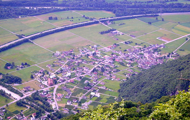
Claro (Claro)

 Hiking in Claro
Claro, a picturesque village in the southern part of Switzerland, is nestled in the Ticino region, a gem for hikers and outdoor enthusiasts. The region offers a variety of trails that highlight its stunning landscapes, diverse flora, and charming valleys. Here are some key aspects to consider when hiking in Claro:
Trails and Routes
- Sentiero dei Mulini: This scenic path connects various old mills in the region and gives you a wonderful glimpse of local history and nature.
- Valle di Claro: The valley offers several routes, suitable for different skill levels, ranging from easy walks to more challenging hikes. The views of the mountains and the surrounding countryside are breathtaking.
- Monte Carasso: A hike to the nearby Monte Carasso provides a steeper challenge, but rewards hikers with panoramic views of the Bellinzona valley and surrounding peaks.
- Pico dell’Uomo: For experienced hikers, tackling this peak can be rewarding, offering even more spectacular vistas.
Tips for Hiking in Claro
- Best Time to Visit: Late spring through early autumn (May to October) is ideal, as the weather is generally milder and the trails are accessible.
- Gear: Wear sturdy hiking boots, dress in layers, and bring plenty of water and snacks. A good map or a GPS device is essential for navigation.
- Local Weather: The weather can change quickly, especially at higher elevations, so it’s crucial to check the forecast before heading out.
- Respect Nature: Stay on marked trails, and follow the local regulations to preserve the beautiful landscapes and wildlife.
Cultural and Scenic Highlights
- Views of Bellinzona: Enjoy stunning views of the nearby town of Bellinzona, known for its UNESCO World Heritage-listed castles.
- Vineyards: The area is known for its vineyards, so you may encounter charming vineyards along your hike.
- Wildlife: Keep an eye out for local wildlife; the biodiversity adds an extra layer of enjoyment to your hike.
Accommodations and Amenities
- There are several lodging options in Claro and surrounding areas, from hotels to guesthouses. Some may even offer hiking packages.
- Local restaurants and cafes can provide opportunities to taste regional specialties after your hike.
Hiking in Claro is an enriching experience that combines adventure with the beauty of Switzerland's natural landscape. Whether you are an experienced hiker or a beginner, you will find trails suitable for your skill level and enjoy the serene environment that this region has to offer.
- Страна:

- Почтовый код: 6702
- Телефонный код: 091
- Код автомобильного номера: TI
- Координаты: 46° 15' 58" N, 9° 2' 12" E


- GPS треки (wikiloc): [Ссылка]
- Высота над уровнем моря: 989 м m
- Площадь: 21.22 кв.км
- Веб сайт: http://www.comune-claro.ch
- Википедия английская: wiki(en)
- Википедия национальная: wiki(de)
- Хранилище Wikidata: Wikidata: Q68003
- Катеория в википедии: [Ссылка]
- код Freebase: [/m/0gx043]
- код GeoNames: Альт: [7285519]
- код VIAF: Альт: [292145858139123022306]
- ID отношения в OpenStreetMap: [1684662]
- код GND: Альт: [4636571-0]
- идентификатор HDS: [2249]
- код швейцарского муниципалитета: [5282]
Граничит с регионами:


Сан-Витторе
Hiking in Сан-Витторе
San Vittore, located in the canton of Graubünden in Switzerland, offers a variety of hiking opportunities amidst stunning alpine scenery. Here’s an overview of what to expect when hiking in this beautiful region:...
- Страна:
- Почтовый код: 6534
- Телефонный код: 091
- Код автомобильного номера: GR
- Координаты: 46° 14' 17" N, 9° 6' 22" E
- GPS треки (wikiloc): [Ссылка]
- Высота над уровнем моря: 688 м m
- Площадь: 22.06 кв.км
- Население: 825
- Веб сайт: [Ссылка]


Lumino
Hiking in Lumino
Lumino is a picturesque village located in the Canton of Ticino, Switzerland, known for its beautiful landscapes and hiking opportunities. The region offers a range of trails suitable for different skill levels, from easy walks to more challenging hikes....
- Страна:
- Почтовый код: 6533
- Телефонный код: 091
- Код автомобильного номера: TI
- Координаты: 46° 14' 18" N, 9° 4' 5" E
- GPS треки (wikiloc): [Ссылка]
- Высота над уровнем моря: 483 м m
- Площадь: 9.92 кв.км
- Население: 1470
- Веб сайт: [Ссылка]

Gnosca
Hiking in Gnosca
Gnosca, a picturesque village located in the Canton of Ticino in Switzerland, offers a variety of hiking opportunities that take advantage of its beautiful natural surroundings. Here are some key points about hiking in Gnosca:...
- Страна:
- Почтовый код: 6525
- Телефонный код: 091
- Код автомобильного номера: TI
- Координаты: 46° 14' 18" N, 9° 0' 14" E
- GPS треки (wikiloc): [Ссылка]
- Высота над уровнем моря: 801 м m
- Площадь: 7.5 кв.км
- Веб сайт: [Ссылка]
Cresciano
Hiking in Cresciano
Cresciano, located in the scenic Ticino region of Switzerland, offers a variety of hiking opportunities characterized by beautiful landscapes, charming villages, and rich natural diversity. Here are some highlights and tips for hiking in Cresciano:...
- Страна:
- Почтовый код: 6705
- Телефонный код: 091
- Код автомобильного номера: TI
- Координаты: 46° 18' 12" N, 9° 1' 59" E
- GPS треки (wikiloc): [Ссылка]
- Высота над уровнем моря: 1655 м m
- Площадь: 17.19 кв.км
- Веб сайт: [Ссылка]

Arbedo-Castione
Hiking in Arbedo-Castione
Arbedo-Castione is a picturesque area located in the Canton of Ticino, Switzerland. It's known for its beautiful landscapes, rich history, and a variety of hiking trails suitable for different skill levels. Here are some aspects to consider when hiking in Arbedo-Castione:...
- Страна:
- Телефонный код: 091
- Код автомобильного номера: TI
- Координаты: 46° 13' 0" N, 9° 3' 0" E
- GPS треки (wikiloc): [Ссылка]
- Высота над уровнем моря: 278 м m
- Площадь: 21.52 кв.км
- Население: 5039
- Веб сайт: [Ссылка]
Preonzo
Hiking in Preonzo
Preonzo is a picturesque village located in the region of Ticino in southern Switzerland, nestled in the valley of the River Brenno. It's a fantastic area for hiking enthusiasts, offering a range of trails that cater to different skill levels. Here are some highlights and tips for hiking in Preonzo:...
- Страна:
- Почтовый код: 6523
- Телефонный код: 091
- Код автомобильного номера: TI
- Координаты: 46° 16' 0" N, 9° 0' 0" E
- GPS треки (wikiloc): [Ссылка]
- Высота над уровнем моря: 250 м m
- Площадь: 16.44 кв.км