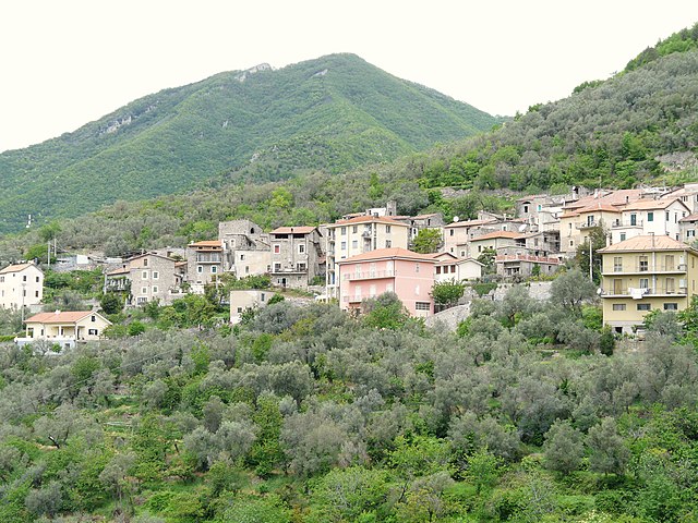
Арнаско (Arnasco, Arnasco)
.svg)
- коммуна Италии
 Hiking in Арнаско
Arnasco is a charming village located in the Liguria region of Italy, near the coast and surrounded by beautiful natural landscapes, making it a great destination for hiking enthusiasts. Here’s an overview of what you can expect when hiking in and around Arnasco:
Scenic Trails
The area around Arnasco features a variety of hiking trails that cater to different levels of experience. You can find paths that wind through lush forests, olive groves, and vineyards, offering not only great views but also opportunities to experience the local flora and fauna.
Popular Hiking Routes
-
Arnasco Village Loop: A moderate trail that starts and ends in Arnasco, taking you around the village and through the surrounding countryside. It’s a great way to see traditional Ligurian architecture and enjoy the scenic views.
-
Monte Settepani: This hike leads you to the summit of Monte Settepani, offering stunning panoramic views of the coastline and the surrounding hills. The trail is a bit challenging but rewarding for the effort.
-
Lower Lerrone Valley: A gentle hike through the picturesque Lower Lerrone Valley offers a serene experience and the chance to see quaint farmhouses and local wildlife.
Tips for Hiking in Arnasco
- Best Time to Go: The ideal seasons for hiking are spring and fall when the weather is mild and the vegetation is lush.
- Preparation: Ensure you have proper hiking gear, including sturdy shoes, water, snacks, and a map or GPS device, as some trails may not be well-marked.
- Local Regulations: Always check for any local guidelines or regulations regarding trail access and preserve the natural environment by following Leave No Trace principles.
- Weather Awareness: The weather can change rapidly, so it’s wise to check the forecast and be prepared for varying conditions.
Additional Activities
Aside from hiking, Arnasco offers opportunities for exploring local culture, cuisine, and wines. Consider trying local olive oil or enjoying a meal in one of the village's traditional restaurants after your hike.
In summary, hiking in and around Arnasco provides stunning natural beauty, cultural experiences, and a chance to explore the tranquil countryside of Liguria. Enjoy your adventure!
- Страна:

- Почтовый код: 17032
- Телефонный код: 0182
- Код автомобильного номера: SV
- Координаты: 44° 4' 41" N, 8° 6' 26" E


- GPS треки (wikiloc): [Ссылка]
- Высота над уровнем моря: 250 м m
- Площадь: 6.09 кв.км
- Население: 632
- Веб сайт: http://www.comunearnasco.it/
- Википедия русская: wiki(ru)
- Википедия английская: wiki(en)
- Википедия национальная: wiki(it)
- Хранилище Wikidata: Wikidata: Q270512
- Катеория в википедии: [Ссылка]
- код Freebase: [/m/0gbzck]
- код GeoNames: Альт: [6542499]
- ID отношения в OpenStreetMap: [42839]
- код ISTAT: 009007
- кадастровый код Италии: A422
Граничит с регионами:


Цуккарелло
- коммуна Италии
Hiking in Цуккарелло
Zuccarello is a charming village located in Liguria, Italy, known for its medieval architecture and beautiful natural surroundings. It's an excellent spot for hiking enthusiasts due to its picturesque landscapes and various trails. Here are some key points about hiking in and around Zuccarello:...
- Страна:
- Почтовый код: 17039
- Телефонный код: 0182
- Код автомобильного номера: SV
- Координаты: 44° 6' 35" N, 8° 7' 5" E
- GPS треки (wikiloc): [Ссылка]
- Высота над уровнем моря: 130 м m
- Площадь: 10.81 кв.км
- Население: 317
- Веб сайт: [Ссылка]


Альбенга
- коммуна Италии
Hiking in Альбенга
Albenga, located on the Italian Riviera in the region of Liguria, is not only known for its beautiful beaches and historic architecture but also offers various hiking opportunities. The surrounding areas feature stunning landscapes, coastal trails, and hilly terrain that can cater to both novice and experienced hikers....
- Страна:
- Почтовый код: 17031
- Телефонный код: 0182
- Код автомобильного номера: SV
- Координаты: 44° 2' 57" N, 8° 12' 47" E
- GPS треки (wikiloc): [Ссылка]
- Высота над уровнем моря: 5 м m
- Площадь: 36.58 кв.км
- Население: 24042
- Веб сайт: [Ссылка]

Кастельбьянко
- коммуна Италии
Hiking in Кастельбьянко
Castelbianco is a picturesque village located in the Liguria region of Italy, known for its stunning landscapes and rich history. Hiking in this area offers an exhilarating experience with a mix of coastal views, lush forests, and charming rural scenery....
- Страна:
- Почтовый код: 17030
- Телефонный код: 0182
- Код автомобильного номера: SV
- Координаты: 44° 6' 47" N, 8° 4' 27" E
- GPS треки (wikiloc): [Ссылка]
- Высота над уровнем моря: 285 м m
- Площадь: 14.7 кв.км
- Население: 325
- Веб сайт: [Ссылка]


Чизано-суль-Нева
- коммуна Италии
Hiking in Чизано-суль-Нева
Cisano sul Neva is a charming village located in the Liguria region of Italy, nestled in the hills along the Neva River. The surrounding area offers a range of hiking opportunities, making it a great destination for outdoor enthusiasts....
- Страна:
- Почтовый код: 17035
- Телефонный код: 0182
- Код автомобильного номера: SV
- Координаты: 44° 5' 14" N, 8° 8' 42" E
- GPS треки (wikiloc): [Ссылка]
- Высота над уровнем моря: 52 м m
- Площадь: 12.27 кв.км
- Население: 2085
- Веб сайт: [Ссылка]


Ортоверо
- коммуна Италии
Hiking in Ортоверо
Ortovero, a charming town located in the Liguria region of Italy, offers a variety of hiking opportunities for outdoor enthusiasts. Nestled in the scenic hills of the Riviera, it provides picturesque views of the surrounding countryside as well as access to the beautiful coastal areas....
- Страна:
- Почтовый код: 17037
- Телефонный код: 0182
- Код автомобильного номера: SV
- Координаты: 44° 3' 12" N, 8° 5' 15" E
- GPS треки (wikiloc): [Ссылка]
- Высота над уровнем моря: 63 м m
- Площадь: 9.66 кв.км
- Население: 1566
- Веб сайт: [Ссылка]


Вендоне
- коммуна Италии
Hiking in Вендоне
Vendone is a charming village located in the Liguria region of Italy, situated amidst beautiful landscapes that offer excellent opportunities for hiking enthusiasts. The area features a mix of coastal and inland trails, allowing hikers to explore both the rugged coastline and the lush, green hills....
- Страна:
- Почтовый код: 17032
- Телефонный код: 0182
- Код автомобильного номера: SV
- Координаты: 44° 4' 27" N, 8° 4' 27" E
- GPS треки (wikiloc): [Ссылка]
- Высота над уровнем моря: 398 м m
- Площадь: 9.92 кв.км
- Население: 370
- Веб сайт: [Ссылка]