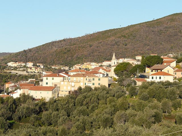
Чизано-суль-Нева (Cisano sul Neva, Cisano sul Neva)
.svg)
- коммуна Италии
 Hiking in Чизано-суль-Нева
Cisano sul Neva is a charming village located in the Liguria region of Italy, nestled in the hills along the Neva River. The surrounding area offers a range of hiking opportunities, making it a great destination for outdoor enthusiasts.
Hiking Opportunities
-
Scenic Trails: The trails around Cisano sul Neva are known for their picturesque landscapes, featuring lush greenery, rolling hills, and charming views of the countryside. Many paths meander through olive groves and vineyards, providing a peaceful setting for hikers.
-
Variety of Difficulty Levels: The area offers trails suitable for all skill levels, from easy walks suitable for families to more challenging hikes for experienced trekkers. Beginners can enjoy gentle walks on well-marked paths, while adventurous hikers can tackle steeper terrains leading to breathtaking viewpoints.
-
Local Flora and Fauna: As you hike, you can expect to see a diverse range of plant species and wildlife unique to the Ligurian landscape. Keep an eye out for various birds, butterflies, and perhaps even some local mammals.
-
Historical and Cultural Sites: Some trails may lead you to historical landmarks such as ancient churches, ruins, and traditional village structures. These cultural sights can provide a deeper appreciation of the region’s heritage during your hike.
-
Connecting to Other Trails: The area around Cisano sul Neva is part of a larger network of trails in the Ligurian region, allowing for extended hikes if you’re looking to explore further. For example, you might connect to trails leading to the nearby towns or to higher elevation paths offering dramatic views of the coastline.
Best Time to Hike
The best times to hike in this region are in the spring (April to June) and early autumn (September to October), when the weather is mild and the landscapes are especially beautiful. Summer can be quite hot, while winter may bring snow to higher elevations.
Preparation Tips
- Gear: Wear appropriate hiking boots and carry a daypack with essentials (water, snacks, first-aid kit).
- Navigation: While trails are often well-marked, having a map or a hiking app can be helpful.
- Weather Check: Always check the weather forecast before heading out, as conditions can change quickly in mountainous areas.
- Respect Nature: Follow Leave No Trace principles, and be mindful of local wildlife and plants.
Conclusion
Cisano sul Neva provides a wonderful backdrop for hiking, combining natural beauty with rich cultural history. Whether you're looking for a leisurely walk or a more strenuous trek, the area offers a rewarding hiking experience. Remember to plan your hikes and take the time to enjoy the stunning landscapes of this beautiful part of Italy!
- Страна:

- Почтовый код: 17035
- Телефонный код: 0182
- Код автомобильного номера: SV
- Координаты: 44° 5' 14" N, 8° 8' 42" E


- GPS треки (wikiloc): [Ссылка]
- Высота над уровнем моря: 52 м m
- Площадь: 12.27 кв.км
- Население: 2085
- Веб сайт: http://www.comune.cisanosulneva.sv.it
- Википедия русская: wiki(ru)
- Википедия английская: wiki(en)
- Википедия национальная: wiki(it)
- Хранилище Wikidata: Wikidata: Q270713
- Галерея изображений в википедии: [Ссылка]
- Катеория в википедии: [Ссылка]
- код Freebase: [/m/0gbzpd]
- код GeoNames: Альт: [6536362]
- код VIAF: Альт: [246988354]
- ID отношения в OpenStreetMap: [42851]
- UN/LOCODE: [ITCNY]
- код Trismegistos: [31688]
- код ISTAT: 009025
- кадастровый код Италии: C729
Граничит с регионами:


Цуккарелло
- коммуна Италии
Hiking in Цуккарелло
Zuccarello is a charming village located in Liguria, Italy, known for its medieval architecture and beautiful natural surroundings. It's an excellent spot for hiking enthusiasts due to its picturesque landscapes and various trails. Here are some key points about hiking in and around Zuccarello:...
- Страна:
- Почтовый код: 17039
- Телефонный код: 0182
- Код автомобильного номера: SV
- Координаты: 44° 6' 35" N, 8° 7' 5" E
- GPS треки (wikiloc): [Ссылка]
- Высота над уровнем моря: 130 м m
- Площадь: 10.81 кв.км
- Население: 317
- Веб сайт: [Ссылка]


Альбенга
- коммуна Италии
Hiking in Альбенга
Albenga, located on the Italian Riviera in the region of Liguria, is not only known for its beautiful beaches and historic architecture but also offers various hiking opportunities. The surrounding areas feature stunning landscapes, coastal trails, and hilly terrain that can cater to both novice and experienced hikers....
- Страна:
- Почтовый код: 17031
- Телефонный код: 0182
- Код автомобильного номера: SV
- Координаты: 44° 2' 57" N, 8° 12' 47" E
- GPS треки (wikiloc): [Ссылка]
- Высота над уровнем моря: 5 м m
- Площадь: 36.58 кв.км
- Население: 24042
- Веб сайт: [Ссылка]

Арнаско
- коммуна Италии
Hiking in Арнаско
Arnasco is a charming village located in the Liguria region of Italy, near the coast and surrounded by beautiful natural landscapes, making it a great destination for hiking enthusiasts. Here’s an overview of what you can expect when hiking in and around Arnasco:...
- Страна:
- Почтовый код: 17032
- Телефонный код: 0182
- Код автомобильного номера: SV
- Координаты: 44° 4' 41" N, 8° 6' 26" E
- GPS треки (wikiloc): [Ссылка]
- Высота над уровнем моря: 250 м m
- Площадь: 6.09 кв.км
- Население: 632
- Веб сайт: [Ссылка]


Балестрино
- коммуна Италии
Hiking in Балестрино
Balestrino is a charming village located in the Liguria region of Italy, known for its beautiful landscapes and rich history. Hiking in and around Balestrino offers stunning views of the surrounding hills, Mediterranean vegetation, and the coastline. Here are some notable aspects of hiking in this area:...
- Страна:
- Почтовый код: 17020
- Телефонный код: 0182
- Код автомобильного номера: SV
- Координаты: 44° 7' 27" N, 8° 10' 14" E
- GPS треки (wikiloc): [Ссылка]
- Высота над уровнем моря: 371 м m
- Площадь: 11.27 кв.км
- Население: 553
- Веб сайт: [Ссылка]


Чериале
- коммуна Италии
Hiking in Чериале
Ceriale, located in the province of Savona in the Liguria region of Italy, is a great destination for hiking enthusiasts. Nestled along the Italian Riviera, it offers stunning coastal views, diverse landscapes, and a variety of trails suitable for different skill levels....
- Страна:
- Почтовый код: 17023
- Телефонный код: 0182
- Код автомобильного номера: SV
- Координаты: 44° 5' 48" N, 8° 13' 56" E
- GPS треки (wikiloc): [Ссылка]
- Высота над уровнем моря: 10 м m
- Площадь: 11.15 кв.км
- Население: 5571
- Веб сайт: [Ссылка]