Авиано (Aviano, Aviano)
.svg)
- коммуна Италии
 Hiking in Авиано
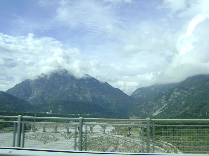
Aviano, located in the northeastern part of Italy, is surrounded by beautiful landscapes that offer numerous hiking opportunities for outdoor enthusiasts. Nestled near the Friuli Venezia Giulia region and the Dolomites, the area provides a mix of mountainous terrain, forests, and valleys, making it an excellent destination for hikers of all levels.
Key Hiking Destinations around Aviano
-
Monte Cavallo (Monte di Aviano):
- A popular peak near Aviano, Monte Cavallo offers panoramic views of the surrounding areas and is suitable for various hiking trails. The routes vary in difficulty, making it accessible for both beginners and experienced hikers.
-
Casera Razzo:
- This is a beautiful area with trails leading through picturesque landscapes filled with diverse flora and fauna. It’s an excellent choice for leisurely hikes and picnics.
-
The Dolomites:
- While a bit further from Aviano, the Dolomites are a must-visit for serious hikers. The famed mountain range offers spectacular trails such as the famous Alta Via routes, which are challenging but rewarding with stunning views.
-
Parco Naturale delle Prealpi Friulane:
- This natural park has numerous trails that lead through lush forests and meadows. It caters to various skill levels, from easy walks to more demanding hikes.
Preparation and Tips
- Trail Maps: Always carry a detailed map of the hiking trails in the area as well as a GPS device if possible.
- Weather Conditions: The weather in the mountains can be unpredictable, so check the forecast before your hike and be prepared for sudden changes.
- Safety Gear: Wear appropriate footwear, bring enough water, snacks, and a first-aid kit. Depending on the season, you might also need trekking poles and other equipment.
- Guided Tours: If you're unfamiliar with the area or new to hiking, consider joining guided tours that can provide local insights and ensure you stay safe.
When to Hike
- Spring and Autumn are ideal for hiking in Aviano as the temperatures are mild and the landscapes are vibrant with flowers or fall colors.
- Summer can be warm, but higher elevations offer cooler temperatures and stunning views. Be aware of potential thunderstorms in the afternoons.
- Winter hiking is also possible, especially for those interested in snowshoeing or winter trekking, but be sure to check trail conditions and avalanche risks.
Hiking in Aviano can be a rewarding experience, offering not just challenges and fitness but also the chance to enjoy Italy's natural beauty. Whether you choose a leisurely stroll or a challenging hike, the scenery is sure to be breathtaking!
- Страна:

- Почтовый код: 33081
- Телефонный код: 0434
- Код автомобильного номера: PN
- Координаты: 46° 4' 0" N, 12° 35' 0" E


- GPS треки (wikiloc): [Ссылка]
- Высота над уровнем моря: 159 м m
- Площадь: 113.35 кв.км
- Население: 9080
- Веб сайт: http://www.comune.aviano.pn.it
- Википедия русская: wiki(ru)
- Википедия английская: wiki(en)
- Википедия национальная: wiki(it)
- Хранилище Wikidata: Wikidata: Q53151
- Катеория в википедии: [Ссылка]
- код Freebase: [/m/05wnn_]
- код GeoNames: Альт: [6540298]
- код VIAF: Альт: [151705775]
- ID отношения в OpenStreetMap: [79263]
- код темы Quora: [Aviano]
- UN/LOCODE: [ITAVI]
- код ISTAT: 093004
- кадастровый код Италии: A516
Граничит с регионами:
Тамбре
- коммуна Италии
Hiking in Тамбре
Tambre, located in the Veneto region of Italy, is renowned for its stunning landscapes and outdoor activities, especially hiking. The hills and mountains in and around Tambre provide a variety of trails suitable for different skill levels, from leisurely walks to more challenging treks....
- Страна:
- Почтовый код: 32010
- Телефонный код: 0437
- Код автомобильного номера: BL
- Координаты: 46° 8' 0" N, 12° 25' 0" E
- GPS треки (wikiloc): [Ссылка]
- Высота над уровнем моря: 922 м m
- Площадь: 45.27 кв.км
- Население: 1366
- Веб сайт: [Ссылка]


Барчис
- коммуна Италии
Hiking in Барчис
Barcis is a picturesque village located in the Friuli Venezia Giulia region of northeastern Italy, surrounded by stunning natural landscapes, including mountains, lakes, and forests. Hiking in Barcis offers a fantastic opportunity to explore the beautiful surroundings and experience the region's rich biodiversity....
- Страна:
- Почтовый код: 33080
- Телефонный код: 0427
- Код автомобильного номера: PN
- Координаты: 46° 11' 0" N, 12° 34' 0" E
- GPS треки (wikiloc): [Ссылка]
- Высота над уровнем моря: 409 м m
- Площадь: 103.41 кв.км
- Население: 256
- Веб сайт: [Ссылка]


Будоя
- коммуна Италии
Hiking in Будоя
Budoia, a picturesque village located in the Friuli Venezia Giulia region of northeastern Italy, offers some beautiful hiking opportunities for outdoor enthusiasts. The surrounding landscape is marked by stunning views, rolling hills, and lush vegetation, making it a great place for both novice and experienced hikers....
- Страна:
- Почтовый код: 33070
- Телефонный код: 0434
- Код автомобильного номера: PN
- Координаты: 46° 3' 0" N, 12° 32' 0" E
- GPS треки (wikiloc): [Ссылка]
- Высота над уровнем моря: 135 м m
- Площадь: 37.36 кв.км
- Население: 2571
- Веб сайт: [Ссылка]


Фонтанафредда
- коммуна Италии
Hiking in Фонтанафредда
Fontanafredda, located in the Friuli-Venezia Giulia region of northern Italy, offers a beautiful hiking experience surrounded by stunning landscapes, mountains, and diverse flora and fauna. It’s part of the broader area that includes the Julian Alps and is known for its picturesque scenery, charming villages, and well-maintained trails....
- Страна:
- Почтовый код: 33074
- Телефонный код: 0434
- Код автомобильного номера: PN
- Координаты: 45° 58' 0" N, 12° 34' 0" E
- GPS треки (wikiloc): [Ссылка]
- Высота над уровнем моря: 52 м m
- Площадь: 46.4 кв.км
- Население: 12521
- Веб сайт: [Ссылка]

Монтереале-Вальчеллина
- коммуна Италии
Hiking in Монтереале-Вальчеллина
Montereale Valcellina, located in the Friuli Venezia Giulia region of Italy, offers stunning landscapes and a variety of hiking opportunities for outdoor enthusiasts. The area is known for its rugged mountains, lush forests, and the picturesque Valcellina valley, making it a hidden gem for hikers....
- Страна:
- Почтовый код: 33086
- Телефонный код: 0427
- Код автомобильного номера: PN
- Координаты: 46° 10' 0" N, 12° 40' 0" E
- GPS треки (wikiloc): [Ссылка]
- Высота над уровнем моря: 317 м m
- Площадь: 67.88 кв.км
- Население: 4365
- Веб сайт: [Ссылка]
Ровередо-ин-Пьяно
- коммуна Италии
Hiking in Ровередо-ин-Пьяно
Roveredo in Piano, located in the province of Pordenone in the Friuli Venezia Giulia region of Italy, is surrounded by stunning natural landscapes that offer a variety of hiking opportunities. Here’s what you can expect when hiking in this area:...
- Страна:
- Почтовый код: 33080
- Телефонный код: 0434
- Код автомобильного номера: PN
- Координаты: 46° 1' 0" N, 12° 37' 0" E
- GPS треки (wikiloc): [Ссылка]
- Высота над уровнем моря: 99 м m
- Площадь: 15.86 кв.км
- Население: 5939
- Веб сайт: [Ссылка]
Сан-Куйрино
- коммуна Италии
Hiking in Сан-Куйрино
San Quirino is a charming municipality located in the Friuli Venezia Giulia region of northeastern Italy. Nestled at the foothills of the Julian Alps, it offers a variety of hiking opportunities suitable for different skill levels. Here are some highlights:...
- Страна:
- Почтовый код: 33080
- Телефонный код: 0434
- Код автомобильного номера: PN
- Координаты: 46° 2' 3" N, 12° 40' 42" E
- GPS треки (wikiloc): [Ссылка]
- Высота над уровнем моря: 116 м m
- Площадь: 51.76 кв.км
- Население: 4328
- Веб сайт: [Ссылка]