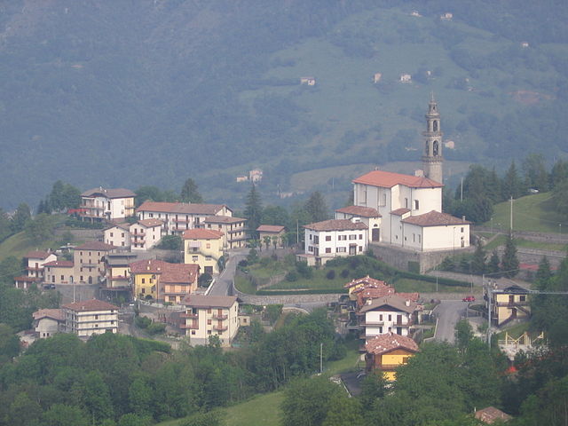
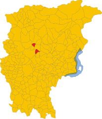
Авьятико (Aviatico, Aviatico)
.svg)
- коммуна Италии
 Hiking in Авьятико
Aviatico is a charming municipality located in the province of Bergamo, in the Lombardy region of Italy. It's situated in the foothills of the Orobie Alps, making it an excellent destination for hiking enthusiasts. Here are some key highlights and tips about hiking in Aviatico:
Trails and Routes
-
Sentiero dei Gussi: This scenic trail offers breathtaking views of the surrounding mountains and valleys. It's suitable for all skill levels and provides a great opportunity to immerse yourself in the natural beauty of the area.
-
Monte Misma: A hike to Monte Misma is a popular choice, providing stunning panoramic views from the summit. The trail is moderately challenging and rewards hikers with vistas of the Bergamasque Alps.
-
Valle Brembana: Exploring the trails in and around the Valle Brembana can lead you to quaint villages, picturesque landscapes, and historic sites. This area is known for its rich biodiversity and beautiful natural scenery.
-
Local Nature Reserves: There are nearby natural parks and reserves where you can explore various trails. The Parco Regionale delle Orobie Bergamasche is particularly notable for its diverse wildlife and stunning landscapes.
Best Time to Hike
- Spring (April to June) and Fall (September to October) are the ideal seasons for hiking in Aviatico due to mild weather and beautiful scenery. Summer can be warm, and winter hiking is possible, but proper gear and experience are necessary for snow-covered trails.
Preparation Tips
- Gear: Wear appropriate hiking boots, dress in layers, and bring a good backpack with water, snacks, and a first aid kit.
- Navigation: While some trails are well-marked, having a map or GPS device can be helpful, especially if you are venturing off the beaten path.
- Local Regulations: Check for any specific regulations regarding trail access and wildlife protection in the area.
Other Activities
In addition to hiking, Aviatico offers opportunities for mountain biking, bird watching, and enjoying local cuisine in nearby restaurants and trattorias. The region is known for its traditional dishes, so be sure to sample some local specialties after your hikes.
Overall, Aviatico provides an excellent mix of stunning natural beauty and diverse hiking experiences, making it a great destination for both novice and seasoned hikers. Enjoy your adventure!
- Страна:

- Почтовый код: 24020
- Телефонный код: 035
- Код автомобильного номера: BG
- Координаты: 45° 48' 2" N, 9° 46' 16" E


- GPS треки (wikiloc): [Ссылка]
- Высота над уровнем моря: 1022 м m
- Площадь: 8.49 кв.км
- Население: 568
- Веб сайт: http://www.comunediaviatico.it
- Википедия русская: wiki(ru)
- Википедия английская: wiki(en)
- Википедия национальная: wiki(it)
- Хранилище Wikidata: Wikidata: Q95079
- Галерея изображений в википедии: [Ссылка]
- Катеория в википедии: [Ссылка]
- код Freebase: [/m/0gj8m3]
- код GeoNames: Альт: [6542940]
- код VIAF: Альт: [241909552]
- ID отношения в OpenStreetMap: [46139]
- код ISTAT: 016015
- кадастровый код Италии: A517
Граничит с регионами:

Коста-Серина
- коммуна Италии
Hiking in Коста-Серина
Costa Serina, located in the province of Bergamo in the Lombardy region of Italy, is a beautiful destination for hiking enthusiasts. Nestled in the scenic foothills of the Alps, it offers a variety of trails that cater to different levels of experience, from casual walkers to seasoned hikers. Here are some key details about hiking in this area:...
- Страна:
- Почтовый код: 24010
- Телефонный код: 0345
- Код автомобильного номера: BG
- Координаты: 45° 49' 58" N, 9° 44' 30" E
- GPS треки (wikiloc): [Ссылка]
- Высота над уровнем моря: 868 м m
- Площадь: 12.3 кв.км
- Население: 912
- Веб сайт: [Ссылка]


Гаццанига
- коммуна Италии
Hiking in Гаццанига
Gazzaniga, a town located in the Lombardy region of Italy, is surrounded by beautiful natural landscapes that provide fantastic opportunities for hiking enthusiasts. While the town itself may not be a well-known hiking destination, its proximity to the Orobian Alps and the Seriana Valley offers a variety of trails suitable for all levels of hikers....
- Страна:
- Почтовый код: 24025
- Телефонный код: 035
- Код автомобильного номера: BG
- Координаты: 45° 48' 0" N, 9° 50' 0" E
- GPS треки (wikiloc): [Ссылка]
- Высота над уровнем моря: 386 м m
- Площадь: 14.41 кв.км
- Население: 5058
- Веб сайт: [Ссылка]


Сельвино
- коммуна Италии
Hiking in Сельвино
Selvino, located in the Bergamo Alps of northern Italy, is a charming destination for hiking enthusiasts. Nestled in the Orobie Mountains, it offers stunning views, diverse landscapes, and a variety of trails suitable for all skill levels. Here’s what you can expect when hiking in Selvino:...
- Страна:
- Почтовый код: 24020
- Телефонный код: 035
- Код автомобильного номера: BG
- Координаты: 45° 47' 0" N, 9° 45' 0" E
- GPS треки (wikiloc): [Ссылка]
- Высота над уровнем моря: 960 м m
- Площадь: 6.53 кв.км
- Население: 2044
- Веб сайт: [Ссылка]


Альбино
- коммуна Италии
Hiking in Альбино
Albino, located in the Lombardy region of Italy, is a charming town nestled in the foothills of the Bergamasque Alps. The area offers a variety of hiking opportunities, making it a great destination for outdoor enthusiasts....
- Страна:
- Почтовый код: 24021
- Телефонный код: 035
- Код автомобильного номера: BG
- Координаты: 45° 45' 38" N, 9° 47' 49" E
- GPS треки (wikiloc): [Ссылка]
- Высота над уровнем моря: 342 м m
- Площадь: 31.81 кв.км
- Население: 17903
- Веб сайт: [Ссылка]

Альгуа
- коммуна Италии
Hiking in Альгуа
It seems there might be a typo in your query, as "Algua" doesn’t correspond to any well-known hiking destination or region. However, if you meant a specific area, such as "Algarve" in Portugal, "Alguacil" in Spain, or "Algul" in another region, please clarify....
- Страна:
- Почтовый код: 24010
- Телефонный код: 0345
- Код автомобильного номера: BG
- Координаты: 45° 50' 0" N, 9° 43' 0" E
- GPS треки (wikiloc): [Ссылка]
- Высота над уровнем моря: 432 м m
- Площадь: 8.32 кв.км
- Население: 673
- Веб сайт: [Ссылка]