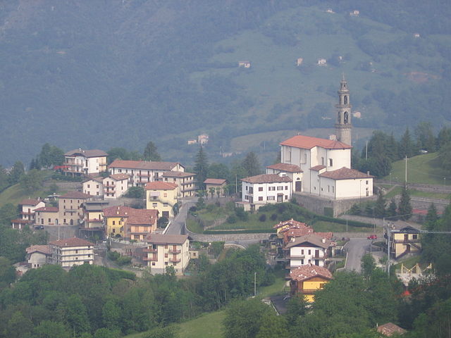
Гаццанига (Gazzaniga, Gazzaniga)
.svg)
- коммуна Италии
 Hiking in Гаццанига
Gazzaniga, a town located in the Lombardy region of Italy, is surrounded by beautiful natural landscapes that provide fantastic opportunities for hiking enthusiasts. While the town itself may not be a well-known hiking destination, its proximity to the Orobian Alps and the Seriana Valley offers a variety of trails suitable for all levels of hikers.
Hiking Opportunities Near Gazzaniga:
-
Orobian Alps: The Orobian Alps are a stunning range with numerous trails. Popular hikes include paths leading to beautiful viewpoints, alpine lakes, and lush forests. Consider hikes like the Val Carbonera, which offers scenic views and varying levels of difficulty.
-
Valle Seriana: The valleys around Gazzaniga have charming trails that wind through villages and quiet woods. The trails often feature historical sites and local flora and fauna. The Val di Scalve offers a range of paths with different difficulty levels.
-
Local Trails: The area around Gazzaniga has marked trails that can be explored, such as those leading to nearby villages or scenic outlooks. The routes often provide breathtaking views of the surrounding mountains and valleys.
Tips for Hiking in Gazzaniga:
-
Prepare Properly: Check the weather forecast and trail conditions before heading out. Bring adequate gear, including sturdy shoes, water, snacks, and a map or GPS.
-
Respect Nature: Stay on marked trails and respect the local wildlife and environment. Carry out any trash to help preserve the beauty of the landscapes.
-
Safety First: Always inform someone about your hiking plans, especially if you are hiking alone. Make sure someone knows your expected return time.
-
Explore Local Culture: Consider combining your hike with a visit to local attractions, such as churches or historical sites, to enrich your experience.
Conclusion:
While Gazzaniga may not be the most famous hiking destination, its access to the Orobian Alps and natural beauty make it an excellent base for outdoor adventures. Whether you're an experienced hiker or a beginner, there are plenty of trails to explore and enjoy the stunning Italian landscape.
- Страна:

- Почтовый код: 24025
- Телефонный код: 035
- Код автомобильного номера: BG
- Координаты: 45° 48' 0" N, 9° 50' 0" E


- GPS треки (wikiloc): [Ссылка]
- Высота над уровнем моря: 386 м m
- Площадь: 14.41 кв.км
- Население: 5058
- Веб сайт: http://www.comune.gazzaniga.bg.it
- Википедия русская: wiki(ru)
- Википедия английская: wiki(en)
- Википедия национальная: wiki(it)
- Хранилище Wikidata: Wikidata: Q101130
- Галерея изображений в википедии: [Ссылка]
- Катеория в википедии: [Ссылка]
- код Freebase: [/m/0gjbh5]
- код GeoNames: Альт: [6536543]
- код VIAF: Альт: [131482828]
- ID отношения в OpenStreetMap: [46136]
- UN/LOCODE: [ITGZI]
- код ISTAT: 016111
- кадастровый код Италии: D952
Граничит с регионами:


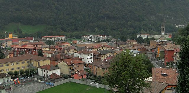
Чене
- коммуна Италии
Hiking in Чене
Cene is a small town located in the province of Bergamo, Lombardy, Italy. It is situated near the foothills of the Alps, which provides a beautiful setting for hiking enthusiasts. Here are some key points if you're considering hiking in and around Cene:...
- Страна:
- Почтовый код: 24020
- Телефонный код: 035
- Код автомобильного номера: BG
- Координаты: 45° 46' 46" N, 9° 49' 33" E
- GPS треки (wikiloc): [Ссылка]
- Высота над уровнем моря: 368 м m
- Площадь: 8.6 кв.км
- Население: 4267
- Веб сайт: [Ссылка]


Корнальба
- коммуна Италии
Hiking in Корнальба
Cornalba is a picturesque village located in the Lombardy region of Italy, nestled in the Bergamo Alps. Its stunning landscapes, lush forests, and scenic views make it a fantastic destination for hiking enthusiasts. Here’s what you need to know about hiking in and around Cornalba:...
- Страна:
- Почтовый код: 24017
- Телефонный код: 0345
- Код автомобильного номера: BG
- Координаты: 45° 51' 0" N, 9° 45' 0" E
- GPS треки (wikiloc): [Ссылка]
- Высота над уровнем моря: 893 м m
- Площадь: 9.25 кв.км
- Население: 305
- Веб сайт: [Ссылка]

Коста-Серина
- коммуна Италии
Hiking in Коста-Серина
Costa Serina, located in the province of Bergamo in the Lombardy region of Italy, is a beautiful destination for hiking enthusiasts. Nestled in the scenic foothills of the Alps, it offers a variety of trails that cater to different levels of experience, from casual walkers to seasoned hikers. Here are some key details about hiking in this area:...
- Страна:
- Почтовый код: 24010
- Телефонный код: 0345
- Код автомобильного номера: BG
- Координаты: 45° 49' 58" N, 9° 44' 30" E
- GPS треки (wikiloc): [Ссылка]
- Высота над уровнем моря: 868 м m
- Площадь: 12.3 кв.км
- Население: 912
- Веб сайт: [Ссылка]

Фьорано-аль-Серио
- коммуна Италии
Hiking in Фьорано-аль-Серио
Fiorano al Serio is a charming town located in the province of Bergamo, in the Lombardy region of northern Italy. Surrounded by the stunning natural beauty of the Orobian Alps, it offers a variety of hiking opportunities for both beginners and experienced hikers....
- Страна:
- Почтовый код: 24020
- Телефонный код: 035
- Код автомобильного номера: BG
- Координаты: 45° 48' 7" N, 9° 50' 35" E
- GPS треки (wikiloc): [Ссылка]
- Высота над уровнем моря: 396 м m
- Площадь: 1.06 кв.км
- Население: 3016
- Веб сайт: [Ссылка]


Вертова
- коммуна Италии
Hiking in Вертова
Vertova is a charming town located in the Bergamo province of Lombardy, Italy, surrounded by picturesque mountains and beautiful landscapes, making it an appealing spot for hikers. The area is characterized by its rich natural beauty, featuring forests, rivers, and stunning views of the surrounding Alps....
- Страна:
- Почтовый код: 24029
- Телефонный код: 035
- Код автомобильного номера: BG
- Координаты: 45° 49' 0" N, 9° 51' 0" E
- GPS треки (wikiloc): [Ссылка]
- Высота над уровнем моря: 397 м m
- Площадь: 15.69 кв.км
- Население: 4642
- Веб сайт: [Ссылка]


Альбино
- коммуна Италии
Hiking in Альбино
Albino, located in the Lombardy region of Italy, is a charming town nestled in the foothills of the Bergamasque Alps. The area offers a variety of hiking opportunities, making it a great destination for outdoor enthusiasts....
- Страна:
- Почтовый код: 24021
- Телефонный код: 035
- Код автомобильного номера: BG
- Координаты: 45° 45' 38" N, 9° 47' 49" E
- GPS треки (wikiloc): [Ссылка]
- Высота над уровнем моря: 342 м m
- Площадь: 31.81 кв.км
- Население: 17903
- Веб сайт: [Ссылка]


Авьятико
- коммуна Италии
Hiking in Авьятико
Aviatico is a charming municipality located in the province of Bergamo, in the Lombardy region of Italy. It's situated in the foothills of the Orobie Alps, making it an excellent destination for hiking enthusiasts. Here are some key highlights and tips about hiking in Aviatico:...
- Страна:
- Почтовый код: 24020
- Телефонный код: 035
- Код автомобильного номера: BG
- Координаты: 45° 48' 2" N, 9° 46' 16" E
- GPS треки (wikiloc): [Ссылка]
- Высота над уровнем моря: 1022 м m
- Площадь: 8.49 кв.км
- Население: 568
- Веб сайт: [Ссылка]