Баллерсдорф (Ballersdorf, Ballersdorf)

- коммуна во Франции
 Hiking in Баллерсдорф
Ballersdorf is a quaint village located in Bavaria, Germany, known for its picturesque landscapes and peaceful countryside. While it may not be widely recognized as a major hiking destination, it does offer some charming trails that provide an opportunity to explore the natural beauty of the Bavarian region.
Hiking in Ballersdorf:
-
Trail Options:
- The area surrounding Ballersdorf features a network of walking and hiking trails that vary in difficulty, catering to both beginner hikers and more experienced adventurers.
- You can often find scenic paths that wind through forests, fields, and along rivers, offering beautiful views of the countryside.
-
Natural Features:
- The region is characterized by rolling hills, dense forests, and agricultural land. It’s an ideal setting for nature lovers, with diverse flora and fauna.
- Look out for local wildlife, birds, and perhaps even the occasional deer while you're hiking.
-
Nearby Attractions:
- If you’re looking to extend your hike, consider exploring nearby areas like the Franconian Switzerland or the scenic trails of the Altmühltal Nature Park.
- The charming towns and villages nearby can provide cultural experiences, from local cuisine to historical sites.
-
Best Time to Hike:
- The best months for hiking in Bavaria typically range from late spring through early fall (May to October), when the weather is pleasant and the landscapes are lush and vibrant.
-
Preparation:
- Make sure to wear sturdy hiking shoes, pack plenty of water, snacks, a first aid kit, and be prepared for sudden weather changes, as conditions can vary in the region.
-
Local Regulations:
- Always follow local hiking guidelines and regulations, such as sticking to marked trails and respecting nature.
Remember to check local hiking maps or consult with local hiking groups for more detailed trail information. Enjoy your hiking experience in Ballersdorf!
- Страна:

- Почтовый код: 68210
- Координаты: 47° 37' 24" N, 7° 9' 36" E


- GPS треки (wikiloc): [Ссылка]
- Площадь: 10.72 кв.км
- Население: 825
- Википедия русская: wiki(ru)
- Википедия английская: wiki(en)
- Википедия национальная: wiki(fr)
- Хранилище Wikidata: Wikidata: Q317589
- Катеория в википедии: [Ссылка]
- код Freebase: [/m/03nph2w]
- код GeoNames: Альт: [6450642]
- номер SIREN: [216800177]
- код BNF: [15271721s]
- код муниципалитета INSEE: 68017
Граничит с регионами:

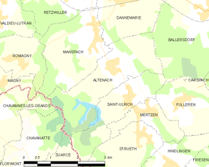
Альтенах
- коммуна во Франции
Hiking in Альтенах
Altenach is a picturesque location that offers a variety of hiking opportunities, ideal for both beginners and experienced hikers. Nestled in a scenic area, Altenach features beautiful landscapes, including lush forests, rolling hills, and breathtaking views....
- Страна:
- Почтовый код: 68210
- Координаты: 47° 36' 24" N, 7° 6' 43" E
- GPS треки (wikiloc): [Ссылка]
- Площадь: 6.18 кв.км
- Население: 378


Карспак
- коммуна во Франции
Hiking in Карспак
Carspach is a quaint commune located in the Alsace region of France, surrounded by scenic landscapes typical of the area. While it may not be as famous as some larger hiking destinations, it offers several opportunities for hikers looking to explore the natural beauty of the Alsace countryside....
- Страна:
- Почтовый код: 68130
- Координаты: 47° 36' 55" N, 7° 12' 43" E
- GPS треки (wikiloc): [Ссылка]
- Площадь: 17.17 кв.км
- Население: 2046


Гоммерсдорф
- коммуна во Франции
Hiking in Гоммерсдорф
Gommersdorf is a small village in Germany, and while it might not be as widely known as some larger hiking destinations, it can still offer some charming trails and beautiful landscapes typically found in the region. Here are a few things to consider when planning a hiking trip in and around Gommersdorf:...
- Страна:
- Почтовый код: 68210
- Координаты: 47° 38' 24" N, 7° 7' 46" E
- GPS треки (wikiloc): [Ссылка]
- Площадь: 4.15 кв.км
- Население: 350

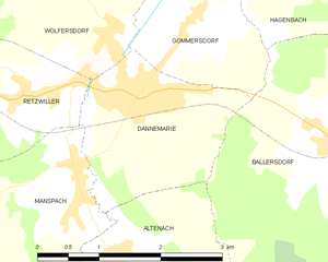
Данмари
Hiking in Данмари
Dannemarie, located in the Haut-Rhin department in the Alsace region of France, offers scenic hiking opportunities that allow you to explore the beautiful landscapes of the region. While the town itself is small, it serves as a great starting point for several hiking routes and outdoor activities in the surrounding areas....
- Страна:
- Почтовый код: 68210
- Координаты: 47° 37' 48" N, 7° 7' 9" E
- GPS треки (wikiloc): [Ссылка]
- Площадь: 4.35 кв.км
- Население: 2252
- Веб сайт: [Ссылка]


Аженбак
- коммуна во Франции
Hiking in Аженбак
Hagenbach, located in the Haut-Rhin department of the Alsace region in northeastern France, offers a picturesque setting that is ideal for hiking enthusiasts. While it may not be as widely recognized as some other hiking destinations in the region, it provides charming paths and trails that allow hikers to explore both the natural landscape and the local culture....
- Страна:
- Почтовый код: 68210
- Координаты: 47° 39' 1" N, 7° 9' 23" E
- GPS треки (wikiloc): [Ссылка]
- Площадь: 4.81 кв.км
- Население: 679

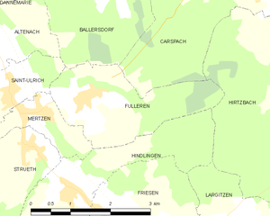
Фюльрен
- коммуна во Франции
Hiking in Фюльрен
Fulleren is a beautiful area that offers various hiking opportunities, characterized by its diverse landscapes and natural beauty. While specific trails may vary depending on the region you are referring to, here are some general tips and information to enhance your hiking experience in any mountainous or natural area that might resemble Fulleren:...
- Страна:
- Почтовый код: 68210
- Координаты: 47° 35' 38" N, 7° 8' 46" E
- GPS треки (wikiloc): [Ссылка]
- Площадь: 5.31 кв.км
- Население: 342
- Веб сайт: [Ссылка]


Сент-Юльрик
- коммуна во Франции
Hiking in Сент-Юльрик
Saint-Ulrich is a picturesque area that offers several hiking opportunities, particularly known for its stunning landscapes and charming surroundings. While the specific trails can vary based on seasonal conditions and local regulations, I can provide a general overview of what you might expect when hiking in the Saint-Ulrich area....
- Страна:
- Почтовый код: 68210
- Координаты: 47° 35' 44" N, 7° 7' 10" E
- GPS треки (wikiloc): [Ссылка]
- Площадь: 3.85 кв.км
- Население: 308