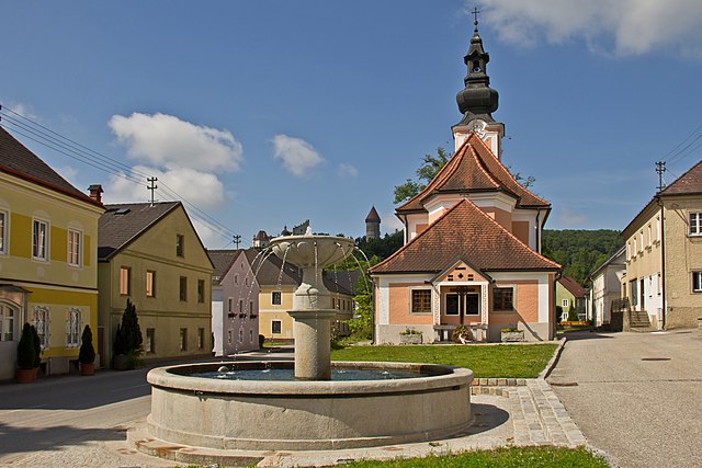
Баумгартенберг (Baumgartenberg, Baumgartenberg)
 Hiking in Баумгартенберг
Baumgartenberg, located in Austria, is a charming area that offers various hiking opportunities for all skill levels. Nestled in the beautiful landscape of Upper Austria, it features rolling hills, lush forests, and stunning views of the surrounding countryside.
Hiking Trails
-
Local Trails: Baumgartenberg offers several well-marked trails that traverse the countryside. These paths are usually suitable for both beginners and experienced hikers, with varying distances.
-
Nature Experiences: Many trails provide the chance to experience diverse flora and fauna, making them great for nature lovers. You may encounter local wildlife and enjoy the serene atmosphere.
-
Cultural Routes: Consider trails that lead to nearby historical sites or villages. You can explore the local culture and heritage, making your hike both scenic and educational.
Tips for Hiking in Baumgartenberg
- Weather: Check the weather conditions before heading out, as they can change quickly. Dress in layers for comfort.
- Footwear: Wear sturdy hiking boots with good grip, as some trails may be uneven or slippery.
- Hydration: Carry enough water, especially on warmer days, and pack snacks to keep your energy up during your hike.
- Local Maps: Grab a local hiking map, available at tourism offices, to help navigate the trails and find points of interest.
- Respect Nature: Always follow Leave No Trace principles to preserve the natural beauty of the area.
Nearby Attractions
- Historical Sites: Explore nearby towns and their historical landmarks for a richer experience.
- Cultural Events: Check out local calendars for any events or festivals happening during your visit, which can enhance your hiking trip.
Whether you're hiking for exercise, exploration, or relaxation, Baumgartenberg offers a peaceful escape into nature with plenty of opportunities to discover its scenic beauty.
- Страна:

- Почтовый код: 4342
- Телефонный код: 07269
- Код автомобильного номера: PE
- Координаты: 48° 12' 32" N, 14° 44' 39" E


- GPS треки (wikiloc): [Ссылка]
- Высота над уровнем моря: 237 м m
- Площадь: 15.73 кв.км
- Население: 1734
- Веб сайт: http://www.baumgartenberg.at/
- Википедия русская: wiki(ru)
- Википедия английская: wiki(en)
- Википедия национальная: wiki(de)
- Хранилище Wikidata: Wikidata: Q678100
- Катеория в википедии: [Ссылка]
- Карты в википедии: [Ссылка]
- код Freebase: [/m/03gv76c]
- код GeoNames: Альт: [7873170]
- код VIAF: Альт: [235004804]
- код GND: Альт: [4004883-4]
- идентификатор местоположения ArchINFORM: [5746]
- код австрийского муниципалитета: [41103]
Граничит с регионами:


Арбинг (Мюльфиртель)
Hiking in Арбинг (Мюльфиртель)
Arbing, a small community located in Austria, is surrounded by beautiful natural landscapes, making it an interesting destination for hiking enthusiasts. While it may not be as well-known as larger hiking regions, there are still many opportunities to explore the outdoors in and around Arbing....
- Страна:
- Почтовый код: 4341
- Телефонный код: 07269
- Код автомобильного номера: PE
- Координаты: 48° 13' 39" N, 14° 42' 27" E
- GPS треки (wikiloc): [Ссылка]
- Высота над уровнем моря: 278 м m
- Площадь: 12.02 кв.км
- Население: 1446
- Веб сайт: [Ссылка]

Ардаггер
Hiking in Ардаггер
Ardagger, located in the province of Lower Austria, offers a variety of hiking opportunities for outdoor enthusiasts. The region is characterized by picturesque landscapes, including the Danube River, lush forests, and rolling hills. Here are some highlights for hiking in and around Ardagger:...
- Страна:
- Почтовый код: 3321
- Телефонный код: 07479
- Код автомобильного номера: AM
- Координаты: 48° 10' 0" N, 14° 49' 0" E
- GPS треки (wikiloc): [Ссылка]
- Высота над уровнем моря: 250 м m
- Площадь: 47.16 кв.км
- Население: 3511
- Веб сайт: [Ссылка]

Миттеркирхен
Hiking in Миттеркирхен
Mitterkirchen im Machland, located in the Upper Austria region, is a beautiful area for hiking enthusiasts. The surrounding landscape features charming countryside, lush green fields, and rolling hills, making it an ideal spot for various hiking trails suitable for all levels....
- Страна:
- Почтовый код: 4343
- Телефонный код: 07269
- Код автомобильного номера: PE
- Координаты: 48° 11' 1" N, 14° 42' 34" E
- GPS треки (wikiloc): [Ссылка]
- Высота над уровнем моря: 235 м m
- Площадь: 28.93 кв.км
- Население: 1718
- Веб сайт: [Ссылка]

Мюнцбах
Hiking in Мюнцбах
Münzbach, a picturesque village in Austria, offers a wonderful environment for hiking enthusiasts. Nestled in the foothills of the Alps, the region presents a range of trails that cater to various skill levels, from leisurely strolls to more challenging hikes....
- Страна:
- Почтовый код: 4323
- Телефонный код: 07264
- Код автомобильного номера: PE
- Координаты: 48° 16' 1" N, 14° 42' 56" E
- GPS треки (wikiloc): [Ссылка]
- Высота над уровнем моря: 421 м m
- Площадь: 24.89 кв.км
- Население: 1814
- Веб сайт: [Ссылка]

Клам
Hiking in Клам
Klamath County, located in southern Oregon, is a fantastic area for hiking, offering diverse landscapes ranging from mountains and forests to lakes and rivers. Here are some highlights:...
- Страна:
- Почтовый код: 4352
- Телефонный код: 07269
- Код автомобильного номера: PE
- Координаты: 48° 13' 29" N, 14° 47' 0" E
- GPS треки (wikiloc): [Ссылка]
- Высота над уровнем моря: 284 м m
- Площадь: 8.36 кв.км
- Население: 918
- Веб сайт: [Ссылка]

Заксен
Hiking in Заксен
Saxen is a picturesque area located in Austria, known for its stunning natural landscapes and outdoor recreational opportunities, including hiking. Here’s an overview of what you can expect when hiking in Saxen:...
- Страна:
- Почтовый код: 4351
- Телефонный код: 07269
- Код автомобильного номера: PE
- Координаты: 48° 12' 21" N, 14° 47' 29" E
- GPS треки (wikiloc): [Ссылка]
- Высота над уровнем моря: 242 м m
- Площадь: 19.07 кв.км
- Население: 1820
- Веб сайт: [Ссылка]