
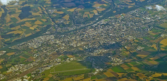
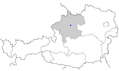
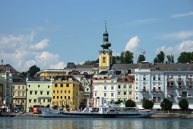
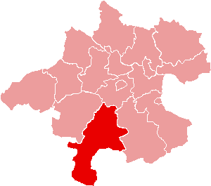
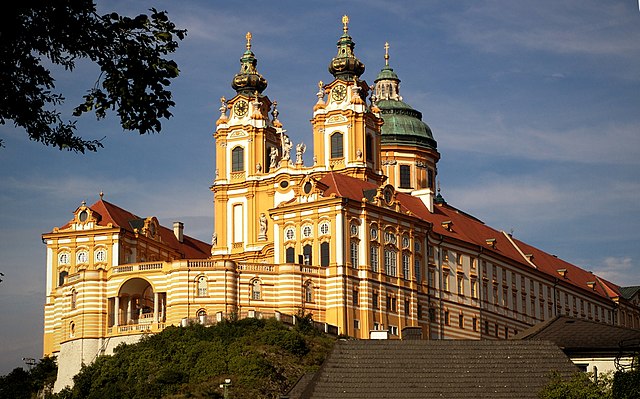
Верхняя Австрия (Upper Austria, Oberösterreich)


 Hiking in Верхняя Австрия
Upper Austria, or "Oberösterreich," offers a diverse range of hiking opportunities, making it a great destination for both beginners and experienced hikers alike. The region is characterized by its picturesque landscapes, including rolling hills, lush valleys, and rugged mountain ranges. Here are some highlights of hiking in Upper Austria:
1.
- Salzkammergut Region: This area, known for its stunning lakes and mountains, offers a variety of trails like the Wolfgangsee and Traunsee lakes. The views of the Dachstein Mountains are particularly breathtaking.
- Mühlviertel: This region features rolling hills and dense forests, with trails that allow hikers to explore charming villages and natural parks, such as the Böhmerwald (Bohemian Forest).
2.
- Nationalpark Kalkalpen: This national park is known for its limestone mountains, deep valleys, and rich biodiversity. There are numerous hiking trails ranging from easy to challenging, complete with well-marked paths and stunning viewpoints.
- Donau-Auen National Park: This wetland area along the Danube River offers unique flora and fauna, along with easy walking trails ideal for family hikes.
3.
- The region has various hiking clubs that organize group hikes, which can be a great way to explore with others. There are also plenty of resources online for trail maps and local advice.
4.
- Trails in Upper Austria can vary widely in difficulty. Many areas offer easy hikes suitable for families, while others lead to more strenuous climbs for advanced hikers. Always check difficulty ratings and trail conditions before heading out.
5.
- The best times for hiking are typically from late spring to early autumn (May to October), when temperatures are mild, and the trails are fully accessible. Winter hiking is also popular, especially in areas with marked winter trails.
6.
- As with any hiking destination, it's essential to prepare adequately. Carry enough water, snacks, and a first-aid kit, and always let someone know your hiking plans. Dress in layers, as the weather can change quickly in the mountains.
7.
- Many trails pass through small villages where you can experience local culture, cuisine, and hospitality. Consider trying traditional dishes like "Kasnock'n" (cheese noodles) after a long hike.
Upper Austria is a beautiful place for hiking, with something to offer for every type of hiker. Whether you're looking for serene lakeside walks or challenging mountain treks, you'll find a variety of options in this stunning region. Enjoy your adventure!
- Страна:

- Столица: Линц
- Координаты: 48° 12' 0" N, 14° 0' 0" E


- GPS треки (wikiloc): [Ссылка]
- Высота над уровнем моря: 343 м m
- Площадь: 11981.92 кв.км
- Население: 1453733
- Веб сайт: http://www.land-oberoesterreich.gv.at/
- Википедия русская: wiki(ru)
- Википедия английская: wiki(en)
- Википедия национальная: wiki(de)
- Хранилище Wikidata: Wikidata: Q41967
- Галерея изображений в википедии: [Ссылка]
- Катеория в википедии: [Ссылка]
- Карты в википедии: [Ссылка]
- код Freebase: [/m/012rrr]
- код GeoNames: Альт: [2769848]
- код BNF: [119431042]
- код VIAF: Альт: [144246745]
- код GND: Альт: [4075560-5]
- идентификатор местоположения ArchINFORM: [2877]
- место в MusicBrainz: [667229dd-a326-49c0-a282-bb7eb3fea5bc]
- код темы Quora: [Upper-Austria]
- код TGN: [7003026]
- код в энциклопедии «Британника онлайн»: [place/Oberosterreich]
- код в Encyclopædia Universalis: [haute-autriche]
- код ISNI: Альт: [0000 0001 1395 7715]
- код NUTS: [AT31]
- код статьи Klexikon: [Oberösterreich]
- STW Thesaurus for Economics ID: [16949-3]
- ISO 3166-2: AT-4
- FIPS 10-4: AU04
Включает регионы:
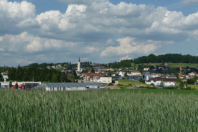
Вельс
Hiking in Вельс
Wels, located in Austria, is not typically known as a major hiking destination, but there are several nearby areas and trails that can offer enjoyable hiking experiences. Here are some key points about hiking around Wels:...
- Страна:
- Телефонный код: 07242
- Код автомобильного номера: WE
- Координаты: 48° 9' 0" N, 14° 1' 0" E
- GPS треки (wikiloc): [Ссылка]
- Высота над уровнем моря: 317 м m
- Площадь: 45.92 кв.км
- Население: 61233
- Веб сайт: [Ссылка]
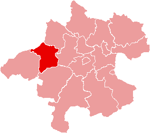
Рорбах
- округ в Австрии, Верхняя Австрия
Hiking in Рорбах
Rohrbach District, located in the southwestern part of Germany, offers a variety of hiking opportunities amidst its scenic landscapes, charming villages, and historical sites. The area is characterized by diverse terrain, including forested hills, meadows, and picturesque valleys, making it an excellent destination for hikers of all skill levels....
- Страна:
- Столица: Рорбах
- Код автомобильного номера: RO
- Координаты: 48° 32' 38" N, 13° 58' 23" E
- GPS треки (wikiloc): [Ссылка]
- Высота над уровнем моря: 583 м m
- Площадь: 817.19 кв.км
- Веб сайт: [Ссылка]
Гмунден
- округ в Верхней Австрии
Hiking in Гмунден
Gmunden District, located in the Salzkammergut region of Austria, is a fantastic destination for hiking enthusiasts. The area is known for its stunning landscapes, including lakes, mountains, and lush forests. Here are some highlights and tips for hiking in the Gmunden District:...
- Страна:
- Столица: Гмунден
- Код автомобильного номера: GM
- Координаты: 47° 54' 4" N, 13° 47' 38" E
- GPS треки (wikiloc): [Ссылка]
- Высота над уровнем моря: 1003 м m
- Площадь: 1432.62 кв.км
- Веб сайт: [Ссылка]

Урфар
Hiking in Урфар
Urfahr-Umgebung District, located in Upper Austria, offers a variety of hiking opportunities that cater to different skill levels and preferences. The district is characterized by picturesque landscapes, rolling hills, lush forests, and stunning viewpoints. Here are some highlights and tips for hiking in the area:...
- Страна:
- Столица: Линц
- Код автомобильного номера: UU
- Координаты: 48° 24' 25" N, 14° 16' 41" E
- GPS треки (wikiloc): [Ссылка]
- Площадь: 660.23 кв.км
- Веб сайт: [Ссылка]
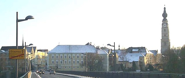
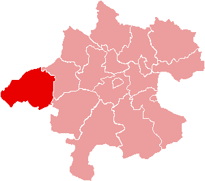
Браунау-ам-Инн
Hiking in Браунау-ам-Инн
Braunau am Inn District, located in Austria near the border with Germany, offers a variety of hiking opportunities that cater to different skill levels and preferences. The landscape is characterized by rolling hills, lush greenery, and scenic views, making it an attractive destination for nature lovers and outdoor enthusiasts....
- Страна:
- Столица: Браунау-ам-Инн
- Код автомобильного номера: BR
- Координаты: 48° 7' 52" N, 13° 6' 32" E
- GPS треки (wikiloc): [Ссылка]
- Высота над уровнем моря: 451 м m
- Площадь: 1040.38 кв.км
- Веб сайт: [Ссылка]
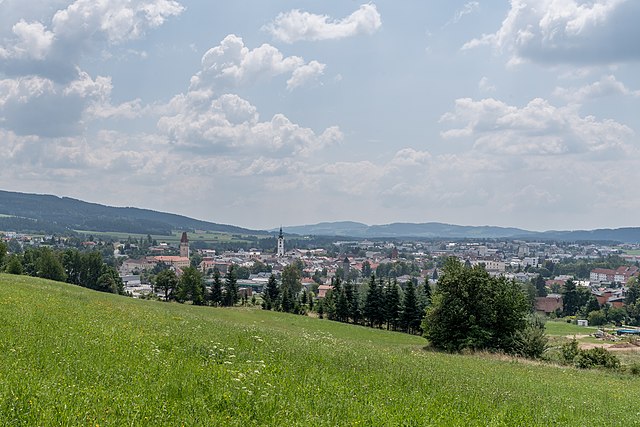
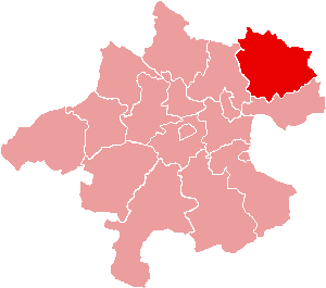
Фрайштадт
Hiking in Фрайштадт
Freistadt District, located in the Upper Austria region of Austria, offers a variety of beautiful landscapes and hiking opportunities for outdoor enthusiasts. Here are some key points to consider when hiking in this area:...
- Страна:
- Столица: Фрайштадт
- Код автомобильного номера: FR
- Координаты: 48° 26' 38" N, 14° 33' 50" E
- GPS треки (wikiloc): [Ссылка]
- Высота над уровнем моря: 700 м m
- Площадь: 993.86 кв.км
- Веб сайт: [Ссылка]

Штайр
Hiking in Штайр
Steyr is a picturesque town in Upper Austria, where the confluence of the Steyr and Enns rivers creates a stunning natural backdrop for hiking enthusiasts. The surrounding area features a variety of trails suitable for both beginners and experienced hikers, with routes offering beautiful views, historical sites, and diverse landscapes....
- Страна:
- Телефонный код: 07252
- Код автомобильного номера: SR
- Координаты: 48° 3' 0" N, 14° 25' 0" E
- GPS треки (wikiloc): [Ссылка]
- Высота над уровнем моря: 310 м m
- Площадь: 26.56 кв.км
- Население: 38331
- Веб сайт: [Ссылка]

Рид-Инн
Hiking in Рид-Инн
Ried im Innkreis is a beautiful region located in Upper Austria, known for its picturesque landscapes, lush nature, and various outdoor activities, including hiking. Here are some notable points about hiking in this district:...
- Страна:
- Столица: Рид
- Код автомобильного номера: RI
- Координаты: 48° 14' 28" N, 13° 26' 6" E
- GPS треки (wikiloc): [Ссылка]
- Высота над уровнем моря: 408 м m
- Площадь: 585.01 кв.км
- Веб сайт: [Ссылка]
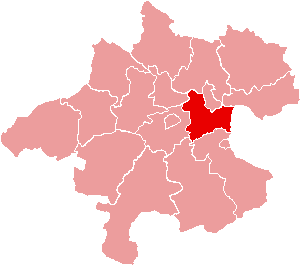
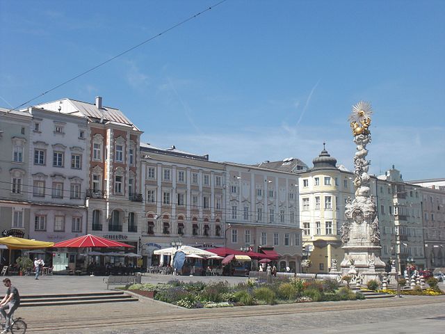
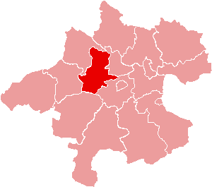
Линц
Hiking in Линц
Linz-Land District, located in the Upper Austria region, is a fantastic destination for hiking enthusiasts. It offers a variety of trails that cater to both beginners and experienced hikers, showcasing the beautiful landscapes, forests, and scenic views of the area....
- Страна:
- Столица: Линц
- Код автомобильного номера: LL
- Координаты: 48° 12' 29" N, 14° 14' 24" E
- GPS треки (wikiloc): [Ссылка]
- Высота над уровнем моря: 297 м m
- Площадь: 460.25 кв.км
- Веб сайт: [Ссылка]

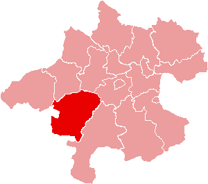
Фёклабрук
Hiking in Фёклабрук
Vöcklabruck District, located in the Upper Austria region, offers a diverse range of hiking opportunities amidst picturesque landscapes, lakes, and rolling hills. Here are some highlights for hikers in the area:...
- Страна:
- Столица: Фёклабрук
- Код автомобильного номера: VB
- Координаты: 48° 0' 32" N, 13° 34' 30" E
- GPS треки (wikiloc): [Ссылка]
- Высота над уровнем моря: 424 м m
- Площадь: 1084.26 кв.км
- Веб сайт: [Ссылка]

Линц
- административный центр федеральной земли Верхняя Австрия
Hiking in Линц
Linz, the third-largest city in Austria, offers a variety of beautiful hiking opportunities in and around the area. Here are some highlights for hiking in and around Linz:...
- Страна:
- Почтовый код: 4030–4039; 4020–4029; 4040–4049; 4010
- Телефонный код: 0732
- Код автомобильного номера: L
- Координаты: 48° 18' 0" N, 14° 17' 0" E
- GPS треки (wikiloc): [Ссылка]
- Высота над уровнем моря: 261 м m
- Площадь: 95.99 кв.км
- Население: 204846
- Веб сайт: [Ссылка]

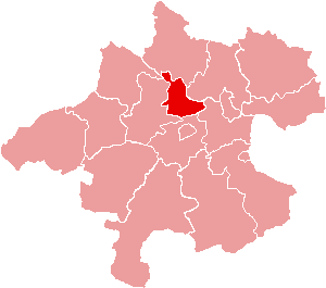
Эфердинг
Hiking in Эфердинг
Eferding District, located in the Upper Austria region of Austria, offers a variety of hiking opportunities that showcase the natural beauty and diverse landscapes of the area. Here are some highlights and tips for hiking in the region:...
- Страна:
- Столица: Эфердинг
- Код автомобильного номера: EF
- Координаты: 48° 19' 1" N, 14° 0' 22" E
- GPS треки (wikiloc): [Ссылка]
- Высота над уровнем моря: 319 м m
- Площадь: 259.46 кв.км
- Веб сайт: [Ссылка]

Шердинг
- округ Австрии
Hiking in Шердинг
Schärding District, located in Upper Austria, is known for its picturesque landscapes, charming towns, and well-marked hiking trails. The area is characterized by rolling hills, lush forests, and the scenic banks of the Inn River, making it an excellent destination for hikers of all skill levels....
- Страна:
- Столица: Шердинг
- Код автомобильного номера: SD
- Координаты: 48° 26' 24" N, 13° 34' 41" E
- GPS треки (wikiloc): [Ссылка]
- Высота над уровнем моря: 489 м m
- Площадь: 618.49 кв.км
- Веб сайт: [Ссылка]

Грискирхен
Hiking in Грискирхен
Grieskirchen District, located in the Upper Austria region of Austria, offers a variety of hiking opportunities that capitalizes on its picturesque landscapes, rich culture, and natural beauty. Here are some highlights about hiking in the Grieskirchen District:...
- Страна:
- Столица: Грискирхен
- Код автомобильного номера: GR
- Координаты: 48° 14' 46" N, 13° 46' 48" E
- GPS треки (wikiloc): [Ссылка]
- Высота над уровнем моря: 431 м m
- Площадь: 578.99 кв.км
- Веб сайт: [Ссылка]

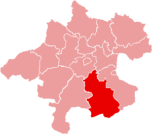
Кирхдорф-на-Кремсе
Hiking in Кирхдорф-на-Кремсе
Kirchdorf an der Krems District, located in Upper Austria, offers a variety of hiking opportunities that showcase the region's stunning natural scenery, including rolling hills, lush forests, and breathtaking mountain views. Here are some highlights and tips for hiking in this area:...
- Страна:
- Столица: Кирхдорф-на-Кремсе
- Код автомобильного номера: KI
- Координаты: 47° 53' 2" N, 14° 9' 29" E
- GPS треки (wikiloc): [Ссылка]
- Высота над уровнем моря: 510 м m
- Площадь: 1239.79 кв.км
- Веб сайт: [Ссылка]

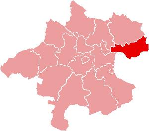
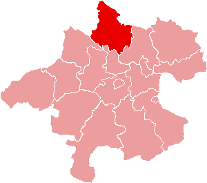
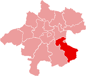
Перг
- округ земли Верхняя Австрия, Австрия
Hiking in Перг
The Perg District, located in the Upper Austria region, offers a variety of hiking opportunities characterized by scenic landscapes, rich cultural heritage, and varying difficulty levels suitable for all types of hikers....
- Страна:
- Столица: Перг
- Код автомобильного номера: PE
- Координаты: 48° 16' 19" N, 14° 40' 59" E
- GPS треки (wikiloc): [Ссылка]
- Высота над уровнем моря: 408 м m
- Площадь: 611.86 кв.км
- Веб сайт: [Ссылка]

Вельс
Hiking in Вельс
Wels-Land District, located in Upper Austria, is a beautiful region that offers a variety of hiking opportunities. The area is characterized by its picturesque landscapes, rolling hills, lush forests, and charming villages. Here are some key points to consider if you are planning to hike in this district:...
- Страна:
- Столица: Вельс
- Код автомобильного номера: WL
- Координаты: 48° 7' 44" N, 13° 57' 25" E
- GPS треки (wikiloc): [Ссылка]
- Высота над уровнем моря: 389 м m
- Площадь: 457.66 кв.км
- Веб сайт: [Ссылка]
Штайр
- округ Австрии
Hiking in Штайр
Steyr-Land District, located in Upper Austria, offers a beautiful environment for hiking enthusiasts. This picturesque region is characterized by its rolling hills, lush forests, and scenic rivers, providing a range of trails suitable for different skill levels....
- Страна:
- Столица: Штайр
- Код автомобильного номера: SE
- Координаты: 48° 0' 50" N, 14° 24' 32" E
- GPS треки (wikiloc): [Ссылка]
- Высота над уровнем моря: 547 м m
- Площадь: 971.70 кв.км
- Веб сайт: [Ссылка]
Граничит с регионами:


Штирия
- земля Австрии
Hiking in Штирия
Styria, a beautiful region in Austria, is a fantastic destination for hiking enthusiasts. Known for its diverse landscapes, lush forests, rolling hills, and stunning alpine views, Styria offers a variety of trails suitable for all experience levels. Here’s what you can expect when hiking in Styria:...
- Страна:
- Столица: Грац
- Координаты: 47° 15' 0" N, 15° 10' 0" E
- GPS треки (wikiloc): [Ссылка]
- Высота над уровнем моря: 2995 м m
- Площадь: 16400.75 кв.км
- Население: 1231865
- Веб сайт: [Ссылка]

Нижняя Австрия
- федеральная земля Австрии
Hiking in Нижняя Австрия
Lower Austria, known as Niederösterreich in German, is a fantastic destination for hiking enthusiasts. The region is characterized by its diverse landscapes, including rolling hills, vineyards, forests, and the scenic Danube River. Here are some highlights and popular hiking areas in Lower Austria:...
- Страна:
- Столица: Санкт-Пёльтен
- Координаты: 48° 20' 0" N, 15° 45' 0" E
- GPS треки (wikiloc): [Ссылка]
- Высота над уровнем моря: 279 м m
- Площадь: 19186.0 кв.км
- Население: 1653419
- Веб сайт: [Ссылка]


Зальцбург
- федеральная земля Австрии
Hiking in Зальцбург
Salzburg, located in Austria, is renowned for its stunning alpine landscapes and rich cultural heritage, making it a fantastic destination for hiking enthusiasts. Here are some highlights and tips for hiking in the state of Salzburg:...
- Страна:
- Столица: Зальцбург
- Координаты: 47° 46' 1" N, 13° 21' 51" E
- GPS треки (wikiloc): [Ссылка]
- Высота над уровнем моря: 827 м m
- Площадь: 7156.03 кв.км
- Население: 545742
- Веб сайт: [Ссылка]


Бавария
- федеральная земля Германии
Hiking in Бавария
Hiking in Bavaria is a fantastic experience, offering a diverse range of landscapes, stunning views, and well-marked trails. Here are some key highlights and tips for hiking in Bavaria:...
- Страна:

- Столица: Мюнхен
- Координаты: 48° 46' 39" N, 11° 25' 52" E
- GPS треки (wikiloc): [Ссылка]
- Высота над уровнем моря: 503 м m
- Площадь: 70551 кв.км
- Население: 12930751
- Веб сайт: [Ссылка]